
Sky-high photography reveals seven essential urban density insights you'd miss from the ground. You'll observe vertical growth patterns, revealing how cities build upwards. Traffic flow visualization exposes congestion hotspots and daily rhythms. Green space distribution highlights the balance between nature and concrete. Population density hotspots show where people cluster most tightly. Urban sprawl boundaries mark city expansion limits. Infrastructure network mapping illustrates the city's connectivity. Architectural diversity from above displays a rich tapestry of styles and eras. These aerial perspectives offer a unique lens on urban development, inviting you to explore the intricate fabric of city life from a new angle.
Vertical Growth Patterns
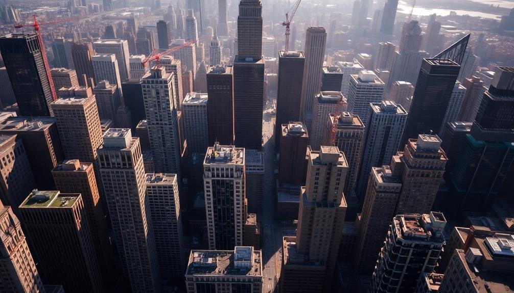
Three key factors drive vertical growth patterns in urban areas: land scarcity, population pressure, and technological advancements. As you observe cities from above, you'll notice how these factors shape skylines and urban landscapes.
Land scarcity forces developers to build upwards, maximizing limited space. You'll see clusters of high-rises in central business districts and along major transit corridors.
Population pressure intensifies the need for vertical growth. As more people flock to cities, you'll witness the transformation of low-rise neighborhoods into areas dotted with apartment towers and mixed-use developments. This vertical expansion allows cities to accommodate more residents without sprawling outwards.
Technological innovations enable taller, more efficient buildings. You'll spot super-tall skyscrapers pushing the limits of engineering, incorporating advanced materials and systems. These structures often become iconic landmarks, reshaping city profiles.
As you examine urban areas from above, you'll recognize patterns of vertical growth radiating from city centers. You'll also notice how zoning regulations and infrastructure capacity influence where and how tall buildings can rise, creating distinct zones of vertical development within the urban fabric.
Traffic Flow Visualization
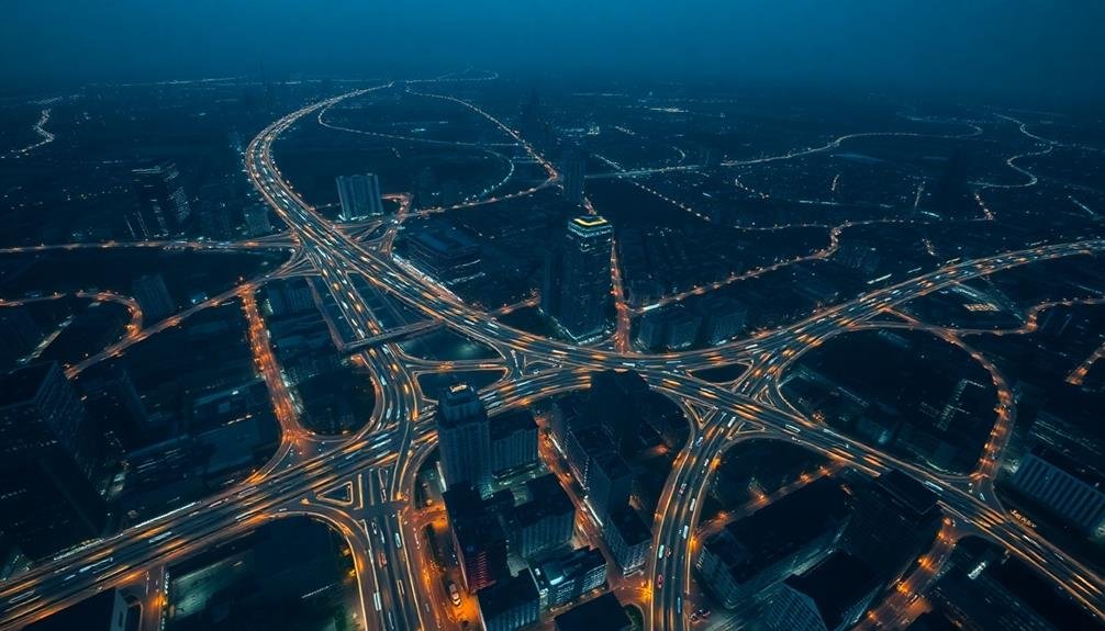
You'll find that traffic flow visualization offers vital insights into urban mobility patterns.
By examining rush hour patterns, you can identify peak congestion times and areas, allowing for targeted infrastructure improvements.
Intersection bottleneck analysis reveals problematic junctions, enabling you to optimize traffic light timing and road design for smoother vehicular movement.
Rush Hour Patterns
Visualizing rush hour patterns reveals the ebb and flow of urban traffic density. From a sky-high perspective, you'll notice how the city's arteries pulse with activity during peak hours. These patterns aren't just random; they're a reflection of the city's daily rhythm, showcasing where people live, work, and play.
As you examine aerial photographs, you'll spot key indicators of rush hour intensity:
- Arterial road congestion
- Highway bottlenecks
- Public transit hubs overflowing with commuters
You'll see how traffic converges on business districts in the morning and disperses in the evening.
These visuals can help urban planners identify problem areas and develop targeted solutions. They might consider widening roads, adjusting traffic light timing, or encouraging alternative transportation methods.
Intersection Bottleneck Analysis
At the heart of urban traffic congestion lies intersection bottleneck analysis. You'll find this technique essential for understanding how traffic flows through critical junctions in densely populated areas. By examining aerial photographs, you can identify problematic intersections that cause considerable delays and backups.
Look for telltale signs of bottlenecks, such as long queues of vehicles stretching back from traffic lights or stop signs. You'll notice patterns emerge, like certain lanes consistently moving slower than others or specific turn movements causing disproportionate delays.
Pay attention to the timing of traffic signals and how they affect the overall flow of vehicles through the intersection. You can use this analysis to propose targeted improvements.
Consider suggesting lane reconfigurations, signal timing adjustments, or even structural changes like adding turn lanes or roundabouts. Don't forget to examine pedestrian and cyclist interactions with vehicular traffic, as these can notably impact intersection efficiency.
Green Space Distribution
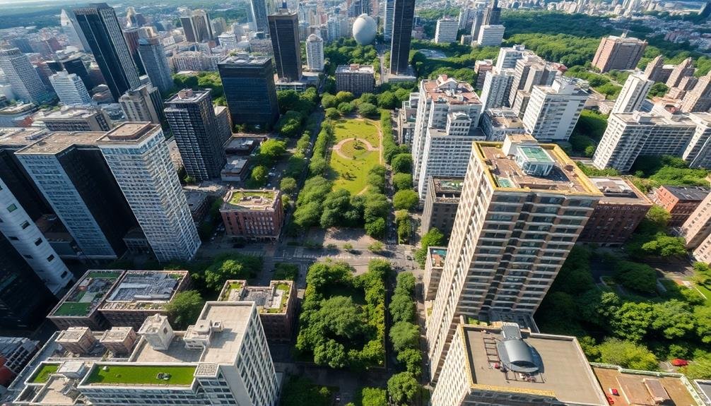
When examining green space distribution in urban areas, you'll want to compare the ratio of parkland to built-up areas.
You can assess how much of the city is dedicated to parks, public gardens, and natural reserves versus developed land.
Additionally, you should consider the prevalence of rooftop gardens, which can greatly contribute to a city's overall green space and provide environmental benefits in densely populated areas.
Parkland vs. Built Areas
Amid the concrete jungle of urban landscapes, the distribution of green spaces plays a significant role in city planning and quality of life. As you examine aerial photographs, you'll notice the stark contrast between parkland and built-up areas. These images reveal the delicate balance cities must strike between development and preserving natural spaces.
You'll observe that well-planned cities often incorporate a network of parks and green corridors interwoven with urban structures. This approach offers numerous benefits:
- Improved air quality and temperature regulation
- Enhanced biodiversity and wildlife habitats
- Increased opportunities for recreation and community engagement
When analyzing these aerial views, pay attention to the ratio of parkland to built areas. Cities with higher proportions of green space tend to be more livable and environmentally sustainable.
You'll also notice how parks and green belts can serve as natural boundaries between neighborhoods or districts, helping to define the city's structure.
As urban populations continue to grow, it's essential to prioritize the preservation and expansion of parkland. By maintaining a healthy balance between built areas and green spaces, cities can guarantee a higher quality of life for their residents while mitigating the environmental impacts of urbanization.
Rooftop Gardens Prevalence
Looking beyond traditional ground-level parks, you'll find an innovative approach to urban green spaces: rooftop gardens. These elevated oases are becoming increasingly prevalent in dense urban areas, offering a creative solution to the green space shortage.
You'll notice rooftop gardens popping up on various structures:
| Building Type | Garden Features |
|---|---|
| Office Buildings | Employee relaxation areas, lunch spots |
| Residential Complexes | Community gardens, social spaces |
| Schools | Educational gardens, outdoor classrooms |
| Hospitals | Healing gardens, therapy spaces |
As you scan the cityscape, you'll see these green patches dotting the rooftops, providing numerous benefits. They're improving air quality, reducing urban heat island effects, and managing stormwater runoff. You'll also find they're enhancing biodiversity by creating habitats for birds and insects.
The prevalence of rooftop gardens varies by city, but you'll generally see higher concentrations in eco-conscious urban centers. Some cities are even implementing policies to encourage their development. As you explore urban areas, keep an eye out for these sky-high green spaces – they're reshaping the urban environment and redefining our relationship with nature in cities.
Population Density Hotspots
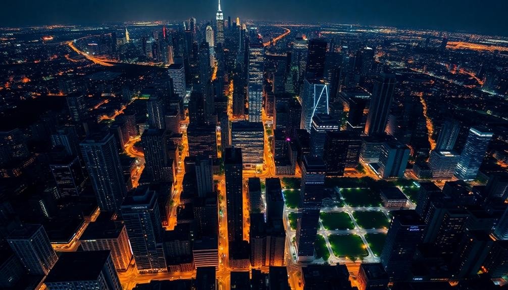
Three major urban centers stand out as population density hotspots globally. When you look at aerial photographs of these cities, you'll see a sea of buildings, streets, and people packed tightly together. Manila, Philippines tops the list with an astounding 46,000 people per square kilometer. Mumbai, India follows closely, and Dhaka, Bangladesh rounds out the top three.
You might wonder why these cities are so densely populated. Several factors contribute:
- Limited land availability
- Rapid urbanization and migration
- Historical city planning decisions
As you examine these hotspots from above, you'll notice the lack of green spaces and the prevalence of narrow streets. High-rise buildings dominate the skyline, often with multiple families sharing a single floor. Public transportation becomes essential in these areas, as personal vehicles simply can't be accommodated.
Understanding these density hotspots is important for urban planners and policymakers. They're constantly seeking ways to improve living conditions, manage resources, and enhance infrastructure in these crowded spaces.
As cities continue to grow, the insights gained from studying these hotspots will shape the future of urban development worldwide.
Urban Sprawl Boundaries
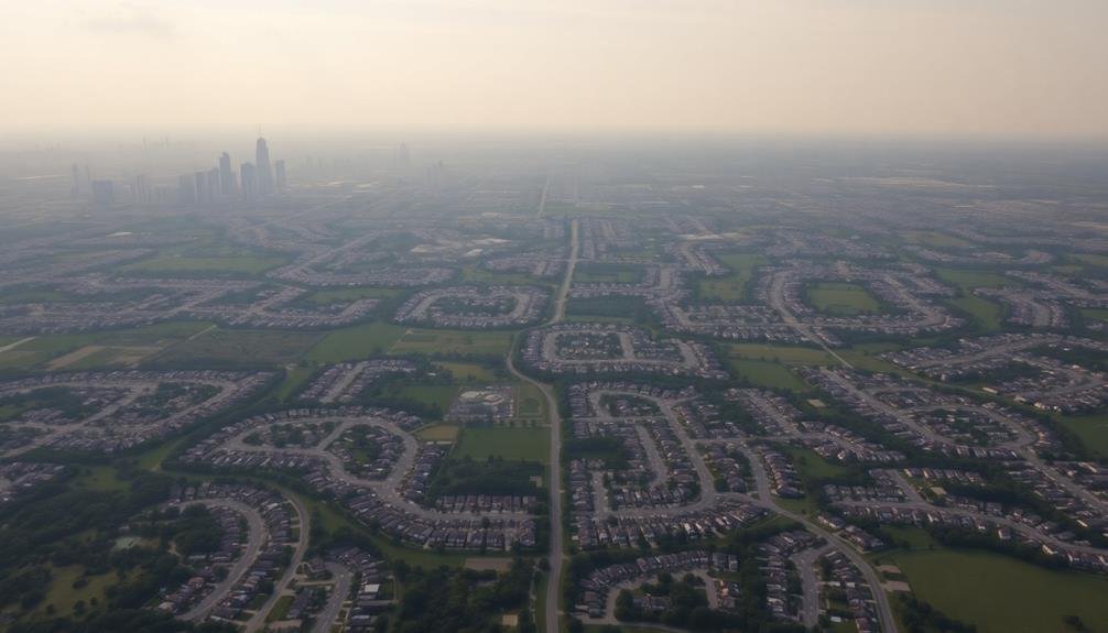
While population density hotspots show us the extremes of urban concentration, urban sprawl boundaries reveal the opposite end of the spectrum. These boundaries mark the outer limits of a city's expansion, where urban development meets rural or undeveloped land. You'll notice these edges in aerial photographs as a stark contrast between built-up areas and open spaces.
Urban sprawl boundaries aren't static; they're constantly shifting as cities grow outward. You can track these changes over time by comparing historical and current imagery. Look for tell-tale signs of sprawl: new housing developments, expanding road networks, and commercial centers popping up on former farmland or natural areas.
These boundaries often follow natural features like rivers, mountains, or protected lands. But they're also shaped by human factors: zoning laws, transportation infrastructure, and economic pressures. You'll see how cities adapt to these constraints, sometimes leapfrogging over barriers to create satellite developments.
Understanding urban sprawl boundaries helps planners manage growth, protect ecosystems, and guarantee efficient resource allocation. By studying these edges, you'll gain insights into a city's development patterns and future challenges.
Infrastructure Network Mapping
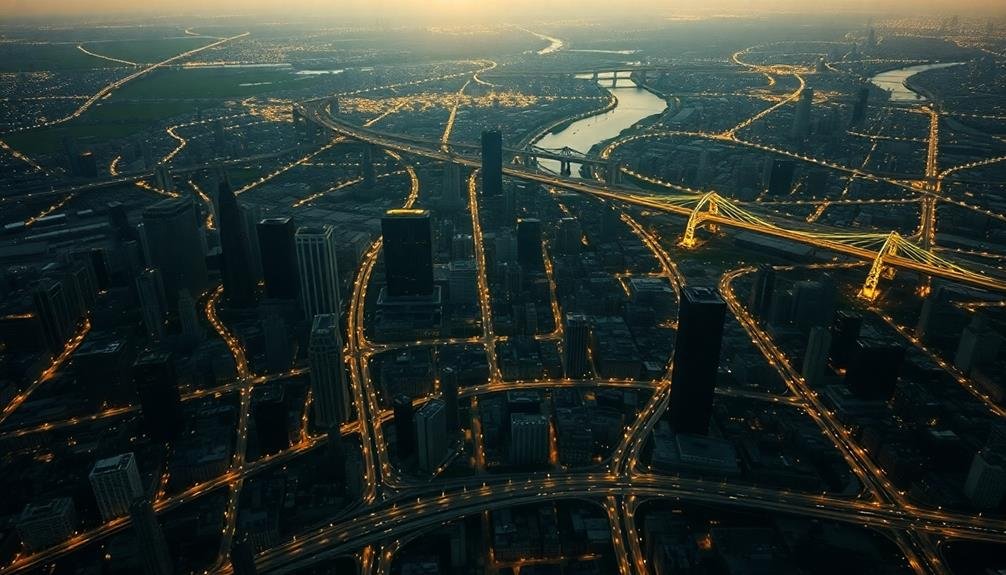
Infrastructure network mapping is an essential tool for understanding urban connectivity and functionality. When you're looking at aerial photographs of cities, you'll see intricate patterns of roads, railways, and utility lines that form the backbone of urban life.
These networks reveal how people, goods, and services move throughout the city, and they're fundamental for urban planning and development.
By analyzing infrastructure networks from above, you can:
- Identify bottlenecks and inefficiencies in transportation systems
- Plan for future expansion and development of utilities
- Assess the city's resilience to natural disasters or system failures
High-resolution aerial imagery allows you to spot minute details of infrastructure, from power substations to water treatment plants.
You'll notice how different neighborhoods are connected and where gaps in service might exist. This information is invaluable for city planners, engineers, and policymakers who need to make informed decisions about urban growth and resource allocation.
As cities become more complex, infrastructure network mapping becomes increasingly important.
It's not just about understanding what exists today, but also about planning for tomorrow's urban challenges and opportunities.
Architectural Diversity From Above
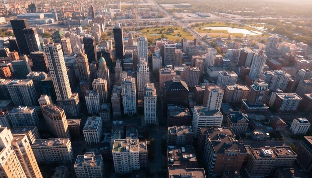
Countless architectural styles become evident when you view cities from above. You'll notice a tapestry of shapes, sizes, and designs that reflect the city's history, culture, and urban planning strategies. From the air, you can easily distinguish between residential, commercial, and industrial areas based on their unique structural patterns.
Historical districts often stand out with their uniform rooflines and consistent building heights, while modern areas showcase a mix of sleek skyscrapers and innovative designs. You'll spot green spaces interspersed among the concrete, providing essential breathing room in dense urban environments.
Here's a quick comparison of common urban architectural styles visible from above:
| Style | Characteristics | Typical Locations |
|---|---|---|
| Gothic | Pointed arches, spires | European city centers |
| Art Deco | Geometric shapes, stepbacks | Early 20th-century downtowns |
| Modernist | Clean lines, glass facades | Business districts |
Frequently Asked Questions
How Do Photographers Capture Aerial Urban Images Safely and Legally?
You can capture aerial urban images safely and legally by using drones with proper permits, hiring helicopter tours, or accessing tall buildings. Always check local regulations, obtain necessary permissions, and prioritize safety when shooting from high vantage points.
What Camera Equipment Is Best Suited for High-Altitude Urban Photography?
For high-altitude urban photography, you'll want a camera with high resolution and dynamic range. Consider full-frame DSLRs or mirrorless cameras with wide-angle lenses. Don't forget image stabilization and filters to combat atmospheric haze and glare.
How Often Are Aerial Urban Photographs Updated for Research Purposes?
You'll find that aerial urban photos for research are updated at varying frequencies. It's common to see annual updates, but some projects may refresh images quarterly or even monthly, depending on the research goals and funding available.
Can Aerial Photography Detect Socioeconomic Differences in Urban Neighborhoods?
Yes, aerial photography can reveal socioeconomic differences in urban neighborhoods. You'll notice variations in housing sizes, green spaces, and infrastructure quality. It's a powerful tool that lets you visualize wealth disparities and urban development patterns from above.
What Role Does Weather Play in Capturing Clear Aerial Urban Images?
Weather plays an essential role in aerial urban photography. You'll need clear skies for the best shots. Clouds, rain, and fog can obscure details, while strong winds might affect your camera's stability. Ideal lighting conditions are essential.
In Summary
You've now seen how aerial photography reveals urban density's hidden patterns. From vertical growth to sprawl boundaries, these images offer unique insights into city planning and development. As you consider urban landscapes, remember the power of this bird's-eye view. It'll help you understand traffic flow, green space distribution, and infrastructure networks better. Next time you're in a high-rise or airplane, take a moment to observe the city below – you'll see it in a whole new light.
As educators and advocates for responsible drone use, we’re committed to sharing our knowledge and expertise with aspiring aerial photographers.


Leave a Reply