
Aerial technologies are exposing climate change's hidden impacts on our planet. From satellites to drones, these eyes in the sky capture shrinking glaciers, receding coastlines, and shifting ecosystems. You'll see deforestation patterns, urban sprawl, and extreme weather events reshaping landscapes. High-resolution imagery tracks wildlife movements and habitat loss, revealing species displacement due to changing environments. Drones offer precision monitoring of glacier retreat, coastal erosion, and air quality at various altitudes. They're revolutionizing conservation efforts by providing real-time data in remote areas. These aerial views offer a unique perspective on climate change's far-reaching effects, helping scientists and policymakers better understand and address our changing world.
Aerial Perspective on Climate Change

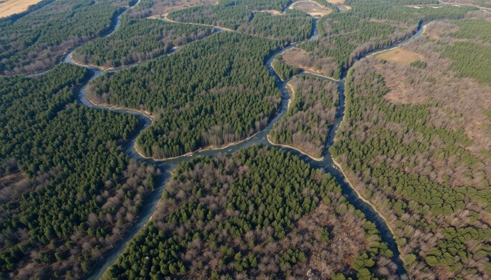
Countless aerial observations have revealed the stark reality of climate change from above. You'll see dramatic changes in landscapes that aren't always visible from the ground. Satellite imagery and aerial photography capture the big picture, showing how our planet is transforming over time.
From this bird's-eye view, you'll notice shrinking glaciers, receding coastlines, and expanding deserts. You can observe the rapid loss of Arctic sea ice, which reflects sunlight and helps regulate global temperatures. You'll also spot deforestation patterns, urban sprawl, and changes in agricultural practices that contribute to climate change.
Aerial perspectives reveal extreme weather events' aftermath, such as more frequent and intense hurricanes, floods, and wildfires. You'll see how these disasters reshape communities and ecosystems. Additionally, you can track changes in vegetation patterns, snowpack levels, and river flows, all indicators of shifting climate conditions.
This unique vantage point allows you to witness long-term trends that might otherwise go unnoticed. It provides essential data for scientists, policymakers, and the public to understand and address the urgent challenges posed by climate change.
Drones: Eyes in the Sky

You'll find drones revolutionizing aerial data collection for climate change research.
These unmanned aircraft offer precision monitoring capabilities, allowing you to track subtle environmental changes over time.
With drones, you're able to conduct thorough environmental impact assessments in areas previously difficult or impossible to access.
Aerial Data Collection
In recent years, drones have revolutionized our ability to monitor and understand climate change's invisible effects. These aerial marvels can collect vast amounts of data quickly and efficiently, providing researchers with unprecedented insights into environmental changes.
You'll find drones equipped with various sensors and cameras, capable of capturing high-resolution imagery and measuring everything from temperature to air quality. They can survey large areas in a fraction of the time it would take ground-based teams, allowing for more frequent and thorough monitoring.
Drones excel at tracking subtle changes in vegetation patterns, coastal erosion, and glacier retreat. They can detect early signs of forest die-off, measure sea-level rise, and even evaluate the health of coral reefs. By collecting data over time, you're able to create detailed maps and 3D models that reveal climate change's progression.
Moreover, drones can access remote or dangerous areas that were previously difficult to study. They're proving invaluable for monitoring wildlife populations, evaluating the impact of extreme weather events, and identifying potential climate-related hazards.
With this wealth of aerial data, you're better equipped to develop targeted strategies for climate change mitigation and adaptation.
Precision Monitoring Capabilities
Drones have become the eyes in the sky for climate scientists, offering unprecedented precision in monitoring environmental changes. You'll find these unmanned aerial vehicles equipped with advanced sensors and cameras, capable of capturing high-resolution images and data that were once impossible to obtain.
They're revolutionizing the way we observe and understand climate change's impacts on our planet.
With drones, you can now:
- Track glacier retreat and ice melt in remote polar regions
- Monitor deforestation and illegal logging activities in real-time
- Assess coastal erosion and sea-level rise with millimeter accuracy
- Measure air quality and greenhouse gas emissions at various altitudes
You'll appreciate how drones allow for frequent, cost-effective data collection without disturbing sensitive ecosystems. They can fly low and slow, capturing detailed information about vegetation health, soil moisture, and wildlife populations.
You're now able to create 3D maps of landscapes, detect subtle changes in terrain, and even identify individual plant species from the air. This precision monitoring enables you to spot early warning signs of environmental stress and make informed decisions to mitigate climate change's effects.
Environmental Impact Assessment
How are drones revolutionizing environmental impact assessments? They're providing a bird's-eye view of ecosystems, allowing you to detect changes that might be invisible from the ground. You can now map large areas quickly and accurately, capturing high-resolution images and data that reveal subtle shifts in vegetation, soil erosion, or wildlife habitats.
With drones, you'll gather real-time information on the effects of climate change, urban development, or industrial activities. You can monitor deforestation rates, track coastal erosion, or assess the health of coral reefs without disturbing fragile ecosystems. These aerial surveys enable you to create detailed 3D models and time-lapse comparisons, helping you identify trends and predict future impacts.
You'll also find that drones make environmental assessments more cost-effective and safer. They can access hard-to-reach or dangerous areas, reducing the need for on-ground personnel.
Mapping Ecosystem Shifts
Over the past decade, scientists have developed sophisticated tools to track ecosystem changes caused by climate change. You'll find that satellite imagery, remote sensing, and advanced modeling techniques are now at the forefront of mapping ecosystem shifts.
These methods allow researchers to observe and analyze large-scale changes in vegetation patterns, species distributions, and habitat boundaries.
You can see the impact of these tools in four key areas:
- Detecting shifts in tree lines and vegetation zones
- Monitoring changes in coastal ecosystems and wetlands
- Tracking the spread of invasive species
- Identifying areas of increased wildfire risk
By using these advanced mapping techniques, you're able to visualize the subtle changes that occur over time. You'll notice how certain plant species are migrating to higher elevations or latitudes as temperatures rise.
You can also observe the expansion or contraction of different ecosystem types, such as forests, grasslands, or tundra.
These maps don't just show current changes; they help predict future shifts. You'll find that this information is essential for conservation efforts, land management decisions, and climate adaptation strategies.
Wildlife Tracking From Above

You might be surprised to learn that scientists are now using high-tech eyes in the sky to track wildlife movements in response to climate change. Satellites, drones, and aircraft equipped with advanced sensors are revolutionizing how we monitor animal populations and their behaviors.
These aerial technologies allow researchers to cover vast areas quickly and efficiently, capturing data that would be impossible to gather from the ground. You'll find that thermal imaging cameras can detect animals' heat signatures, even in dense forests or at night. GPS tracking devices, when attached to animals, provide real-time location data that can be mapped and analyzed.
You're likely wondering how this helps with climate change research. By monitoring wildlife movements over time, scientists can identify shifts in migration patterns, habitat use, and population distributions. These changes often correlate with alterations in temperature, precipitation, and vegetation cover caused by climate change.
You'll see that this bird's-eye view approach is vital for understanding how different species are adapting to our changing planet. This allows conservationists to develop more effective strategies for protecting vulnerable wildlife populations and ecosystems.
Habitat Loss Detection

You can now detect habitat loss with remarkable precision using satellite imagery analysis.
This technology allows you to observe changes in landscapes over time, revealing areas where natural habitats are shrinking or disappearing.
Satellite Imagery Analysis
Satellite imagery has stepped up to the plate in detecting habitat loss due to climate change. You'll find that these high-resolution images from space provide a bird's-eye view of our changing planet, revealing patterns and trends that aren't visible from the ground. By analyzing these images over time, scientists can track the expansion of urban areas, deforestation, and shifts in vegetation cover.
You're now able to witness the invisible effects of climate change through advanced satellite technology. Here's what you can expect to see:
- Coastal erosion and sea-level rise
- Desertification and expanding arid regions
- Shrinking glaciers and ice sheets
- Shifts in plant species distribution
As you explore these satellite images, you'll notice subtle changes that accumulate over time. Colors shift as vegetation patterns change, coastlines recede, and once-frozen landscapes thaw.
You can even track the movement of wildlife populations as they adapt to new conditions. With this powerful tool at your disposal, you're better equipped to understand and address the complex challenges posed by climate change.
Satellite imagery analysis has become an indispensable asset in the fight against habitat loss and environmental degradation.
Species Displacement Tracking
Frequently, species displacement tracking emerges as an essential tool in detecting habitat loss due to climate change. You'll find that this method combines satellite imagery, field observations, and advanced algorithms to monitor shifts in animal populations and vegetation patterns. By analyzing these data sets, you can identify areas where species are moving to new locations or disappearing altogether.
You'll notice that tracking systems often focus on indicator species, which serve as early warning signs for ecosystem changes. For example, you might observe polar bears venturing further south or tropical fish appearing in temperate waters. These shifts can reveal broader climate impacts that aren't immediately visible.
As you explore deeper, you'll discover that species displacement tracking also helps identify critical areas for conservation efforts. By pinpointing regions where habitats are most at risk, you can prioritize protection and restoration initiatives.
Additionally, this tracking allows you to predict future displacement patterns, enabling proactive measures to mitigate habitat loss. Ultimately, species displacement tracking provides valuable insights into the complex web of climate change effects, helping you understand and address the invisible threats to biodiversity.
Conservation Efforts Through Drone Technology

Drone technology has revolutionized conservation efforts in the fight against climate change. You'll find these unmanned aerial vehicles at the forefront of environmental monitoring, providing researchers with unprecedented access to remote areas and real-time data collection.
Drones equipped with high-resolution cameras and sensors can cover vast territories quickly, efficiently tracking changes in ecosystems, wildlife populations, and habitat degradation.
You're now able to witness firsthand the impact of climate change through drone footage. These devices help you:
- Monitor deforestation rates and illegal logging activities
- Track wildlife migrations and population dynamics
- Assess coastal erosion and sea-level rise
- Map and analyze vegetation changes in sensitive ecosystems
Frequently Asked Questions
How Do Drones Affect Wildlife Behavior During Aerial Surveys?
You'll find that drones can disrupt wildlife behavior during aerial surveys. They may cause animals to flee, alter feeding patterns, or experience stress. It's essential you plan carefully and minimize flight time to reduce these impacts.
What Are the Legal Restrictions on Using Drones for Climate Research?
You'll need to check local regulations, as drone laws vary by location. Generally, you're required to register your drone, fly below 400 feet, avoid restricted areas, and maintain visual line-of-sight. Some areas require special permits for research.
Can Drone Technology Detect Subtle Changes in Soil Composition Due to Climate Change?
You'll find that drones equipped with advanced sensors can detect minute changes in soil composition. They'll capture data on moisture levels, organic content, and mineral composition, helping you track climate-induced shifts in soil over time.
How Accurate Are Drone-Based Measurements Compared to Traditional Ground-Based Data Collection Methods?
You'll find that drone-based measurements can be highly accurate, often matching or surpassing traditional ground-based methods. They're faster, cover larger areas, and provide consistent data. However, their accuracy depends on the sensors used and environmental conditions.
What Role Does Artificial Intelligence Play in Analyzing Drone-Collected Climate Change Data?
You'll find AI's essential in analyzing drone-collected climate data. It processes vast amounts of information, identifies patterns, and makes predictions. It'll automate image analysis, detect anomalies, and provide insights that'd be challenging for humans alone.
In Summary
You've seen how aerial technology reveals climate change's hidden impacts. From drones mapping ecosystems to tracking wildlife movements, these eyes in the sky are essential tools. They're helping us detect habitat loss and guide conservation efforts. As you consider the future, remember that what's invisible from the ground becomes clear from above. It's up to you to support and utilize these technologies in the fight against climate change.
As educators and advocates for responsible drone use, we’re committed to sharing our knowledge and expertise with aspiring aerial photographers.


Leave a Reply