You'll be awestruck by these 10 jaw-dropping drone views of ancient world wonders that reveal hidden secrets and breathtaking perspectives never seen before. From the perfect symmetry of the Pyramids of Giza to the intricate network of cenotes surrounding Chichen Itza, each aerial shot offers a unique glimpse into our past. You'll see the Great Wall of China snaking through mountainous terrain, Petra's rose-red cliffs, and Machu Picchu's terraced fields blending seamlessly with nature. These birds-eye views showcase the ingenuity of our ancestors and the enduring beauty of their creations. Prepare to be amazed as you discover the world's most iconic sites from an entirely new angle.
Pyramids of Giza
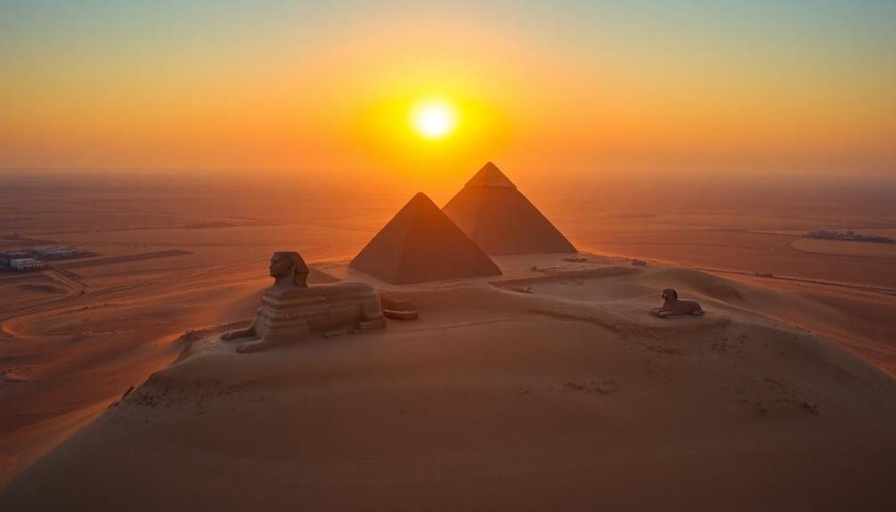
How can you truly grasp the scale of the Pyramids of Giza until you've seen them from above? Drone footage reveals the sheer magnitude of these ancient wonders, showcasing their precise geometry and seamless integration with the surrounding desert landscape.
You'll witness the Great Pyramid of Khufu, the oldest and largest of the three, standing at an impressive 146.5 meters tall. Its smooth limestone casing, now mostly gone, once created a dazzling spectacle visible from miles away.
As your aerial perspective pans across the complex, you'll notice the slightly smaller Pyramid of Khafre, distinguished by its intact limestone cap. The smallest of the trio, Menkaure's Pyramid, completes the iconic skyline. From this vantage point, you can appreciate the careful alignment of these structures with cardinal directions and their relationship to the enigmatic Sphinx.
Drone footage also highlights the intricate network of temples, causeways, and smaller pyramids surrounding the main structures. You'll gain a new appreciation for the ancient Egyptians' engineering prowess as you observe the precise layout and construction techniques that have endured for over 4,500 years.
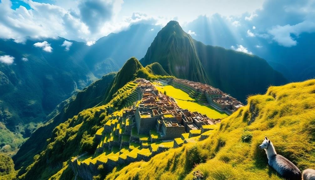
Machu Picchu
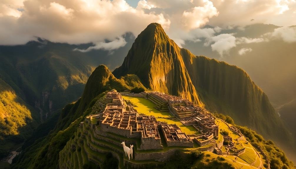
Machu Picchu's hidden splendor comes alive through drone footage, revealing the Incan citadel's true majesty. You'll witness the ancient stone structures perched atop a ridge, surrounded by lush green mountains and swirling mists.
As the drone soars above, you'll see the intricate layout of the city, with its terraced fields, plazas, and temples perfectly preserved. From this aerial perspective, you'll appreciate the incredible engineering feat achieved by the Incas.
You'll notice how the buildings seamlessly blend with the natural landscape, utilizing the mountain's contours. The drone's eye view showcases the site's strategic location, offering insights into its defensive capabilities and astronomical alignments.
You'll marvel at the precise stonework, visible even from above, with massive blocks fitted together without mortar. The drone footage highlights the extensive agricultural terraces, demonstrating the Incas' advanced farming techniques.
As you virtually explore Machu Picchu from the air, you'll gain a deeper understanding of its scale, complexity, and harmonious integration with the environment. This unique vantage point brings new life to one of the world's most enigmatic archaeological sites.
Petra
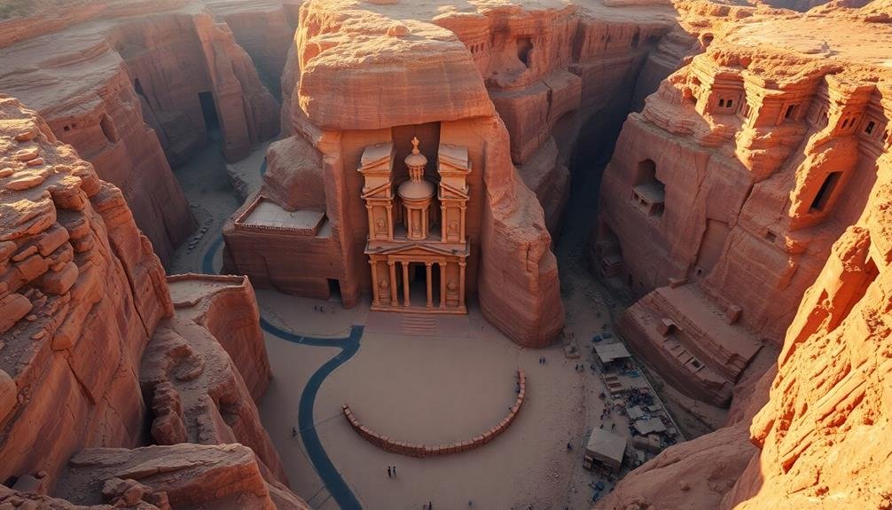
Drone footage of Petra transports you to the heart of the Jordanian desert, revealing the ancient city's grandeur in breathtaking detail. As you soar above the rose-red cliffs, you'll witness the intricate carvings of Al-Khazneh, the iconic Treasury, emerging from the rock face.
The aerial perspective showcases the vast scale of this 2,000-year-old Nabataean capital, with its elaborate tombs and temples stretching across the rugged landscape. You'll marvel at the precision of the ancient architects as you glide over the Street of Facades, a row of monumental tombs carved into the sandstone cliffs.
The drone's eye view reveals the ingenious water conduit system that allowed this desert city to thrive. As you hover above the 8,000-seat amphitheater, you'll appreciate its perfect semicircular shape and imagine the performances that once echoed through the canyon.
The footage captures the stark contrast between the weathered stone structures and the surrounding barren desert, emphasizing Petra's remarkable endurance through millennia. This bird's-eye perspective offers a unique understanding of the city's layout and its harmonious integration with the natural terrain, showcasing why Petra remains one of the world's most awe-inspiring archaeological sites.
Great Wall of China
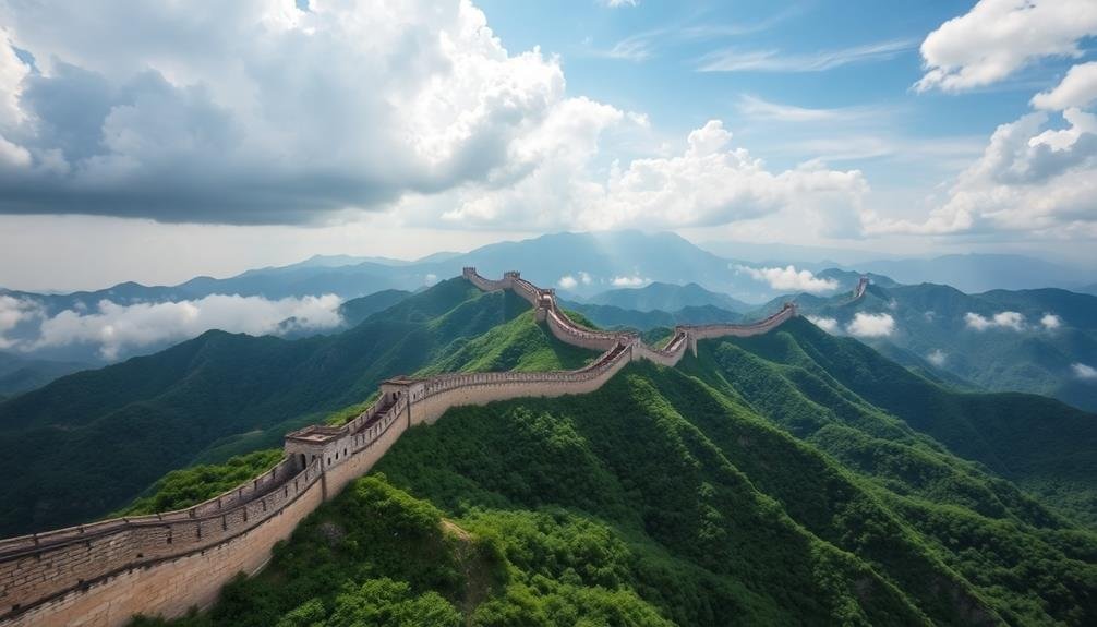
You'll be awestruck by the drone footage of the Great Wall of China, which offers an unparalleled aerial perspective of its immense length.
As you watch, you'll see the ancient structure snaking through rugged mountainous terrain, showcasing its strategic placement and architectural marvel.
The bird's-eye view reveals how the wall adapts to the landscape, following ridgelines and traversing valleys for thousands of kilometers.
Aerial Perspective of Length
From high above, the Great Wall of China unfolds like an endless ribbon across the landscape. As you soar over this ancient wonder in a drone, you'll witness its true magnitude. The wall stretches for thousands of miles, winding through mountains, deserts, and grasslands. Its length becomes even more apparent from this aerial vantage point.
You'll notice how the wall follows the natural contours of the terrain, adapting to steep ridges and valleys. This bird's-eye view reveals sections that aren't accessible by foot, showcasing the wall's full extent. The drone footage captures the wall snaking across different provinces, each segment telling a story of China's rich history.
From this perspective, you can appreciate the immense effort it took to construct such a massive structure. The wall's length is punctuated by watchtowers and fortresses, strategically placed along its course.
As your drone glides along, you'll see how the wall connects these defensive structures, forming an intricate network of ancient engineering. This aerial view truly emphasizes the wall's role as a unifying force in Chinese history and its enduring legacy as a symbol of human perseverance.
Winding Through Mountainous Terrain
As the Great Wall snakes through China's varied landscape, its most impressive sections wind through rugged mountainous terrain.
You'll witness the ancient fortification's remarkable ability to adapt to the challenging topography, hugging steep ridges and traversing seemingly impassable peaks.
From your drone's vantage point, you'll observe how the wall follows the natural contours of the land, creating a mesmerizing pattern of twists and turns.
The aerial perspective reveals the true genius of its design, showcasing how the builders leveraged the mountainous terrain as an additional layer of defense.
As you fly over these sections, you'll notice:
- Steep staircases connecting watchtowers perched on precipitous cliffs
- Narrow passages barely wide enough for a single person to pass
- Dramatic changes in elevation as the wall climbs and descends mountain slopes
- Strategic placement of fortifications at key mountain passes
The drone footage captures the wall's harmonious integration with nature, highlighting how it enhances rather than conquers the landscape.
You'll gain a newfound appreciation for the ingenuity and perseverance of the ancient builders who constructed this marvel in such challenging conditions.
Angkor Wat
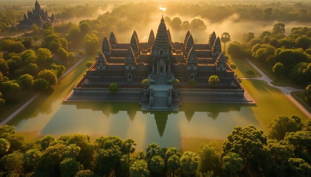
While many ancient wonders impress from ground level, Angkor Wat's true magnificence is best appreciated from above. As your drone soars over this 12th-century Khmer masterpiece, you'll witness its perfect symmetry and intricate layout unfold beneath you.
You'll notice the vast moat surrounding the temple complex, a 650-foot-wide barrier that reflects the temple's silhouette like a mirror. From your aerial vantage point, you can trace the outline of the five iconic towers that form Angkor Wat's distinctive silhouette. These towers represent the five peaks of Mount Meru, the sacred mountain in Hindu mythology.
As you guide your drone closer, you'll spot the intricate bas-reliefs that adorn the temple walls, telling stories of Hindu epics and historical events. The aerial perspective reveals the temple's east-west orientation, designed to face the rising sun.
You'll also see the ancient city of Angkor Thom nearby, with its famous Bayon temple at its center. From above, you can appreciate how these architectural marvels were seamlessly integrated into the surrounding landscape, creating a harmonious blend of human ingenuity and natural beauty.
Stonehenge
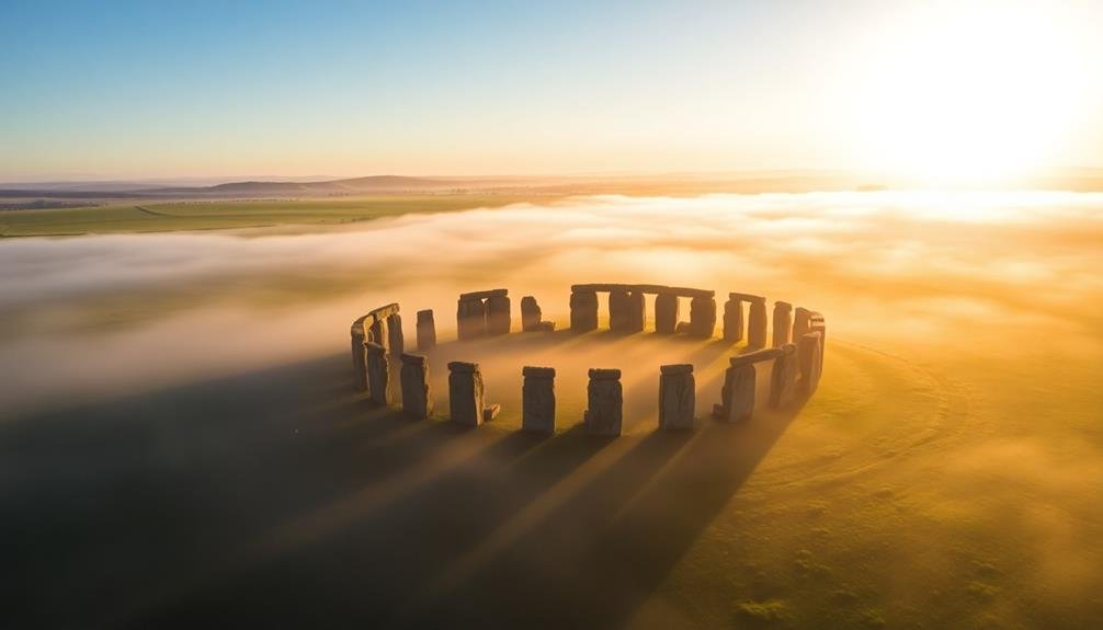
The ancient mystery of Stonehenge takes on a new dimension when viewed from the air. You'll see the iconic stone circle in its entirety, nestled within the vast Salisbury Plain. From above, you'll notice the precise alignment of the stones and their relationship to the surrounding landscape, offering new insights into this Neolithic monument's purpose and construction.
Drone footage reveals details that aren't apparent from ground level. You'll observe:
- The circular ditch and bank enclosing the stone circle
- The Avenue, a long linear earthwork leading to the monument
- Nearby burial mounds and other archaeological features
- The site's alignment with the summer solstice sunrise
As you watch the aerial footage, you'll gain a better understanding of Stonehenge's scale and complexity. The massive sarsen stones, weighing up to 40 tons each, appear even more impressive from above.
You'll see how they're arranged in a horseshoe shape within the outer circle, with smaller bluestones interspersed among them.
The drone's perspective also highlights the monument's isolation, emphasizing its enigmatic nature and leaving you to ponder the incredible feat of engineering accomplished by our ancestors over 4,000 years ago.
Chichen Itza
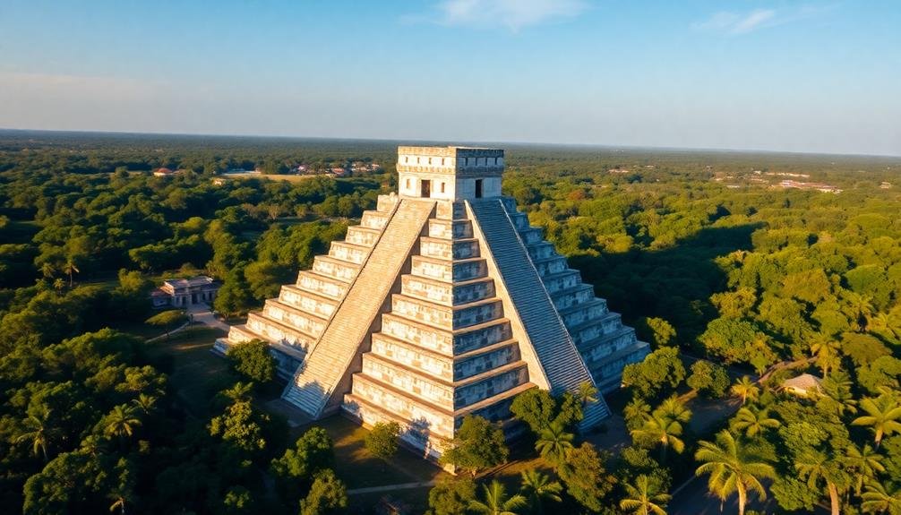
You'll be amazed by the drone footage of Chichen Itza, offering a bird's-eye view of the iconic El Castillo pyramid.
From above, you can appreciate the perfect symmetry and architectural marvel of this ancient Mayan structure.
The aerial perspective also reveals hidden patterns of cenotes, the natural sinkholes sacred to the Maya, scattered across the landscape.
Aerial View of Pyramid
Soaring above the lush Yucatán jungle, you'll spot the iconic El Castillo pyramid at Chichen Itza. This ancient Mayan wonder, also known as the Temple of Kukulcan, stands proudly at the heart of the archaeological site.
From your aerial vantage point, you'll witness the pyramid's perfect symmetry and intricate design, a demonstration of the Mayans' advanced architectural skills.
As your drone circles the pyramid, you'll notice:
- The nine terraced platforms that form the structure's base
- The grand staircase on each of the four sides, leading to the temple at the top
- The serpent-shaped shadows cast by the pyramid during equinoxes
- The surrounding plaza and smaller structures that make up the complex
The bird's-eye view reveals the pyramid's strategic placement within the city, highlighting its importance as a ceremonial center.
You'll see how the structure aligns with other buildings and celestial bodies, showcasing the Mayans' astronomical knowledge. This aerial perspective offers a unique opportunity to appreciate the scale and precision of this ancient marvel, providing insights into the ingenuity of its builders and the civilization they represented.
El Castillo From Above
Hovering above El Castillo, you're instantly struck by its perfect symmetry and geometric precision. The drone's eye view reveals the iconic Mayan pyramid's square base and four stairways, each facing a cardinal direction.
You'll notice the nine terraced levels, representing the nine levels of the Mayan underworld. From this vantage point, you can appreciate the intricate engineering that went into El Castillo's construction.
The pyramid's alignment with celestial bodies becomes apparent, showcasing the Mayans' advanced astronomical knowledge. During equinoxes, the sun casts a shadow resembling a serpent descending the northern stairway, a spectacle best observed from above.
The drone footage captures the stark contrast between the limestone structure and the lush green jungle surrounding it. You'll spot the nearby sacred cenote, a natural sinkhole essential to Mayan religious practices.
The aerial perspective also highlights El Castillo's relationship to other structures within the Chichen Itza complex, including the Great Ball Court and the Temple of the Warriors.
This bird's-eye view offers a unique understanding of El Castillo's role as the centerpiece of Chichen Itza, demonstrating its significance in Mayan culture and architecture.
Cenote Patterns Revealed
Drone footage reveals an intricate network of cenotes surrounding Chichen Itza, previously hidden from ground-level view.
You'll be amazed by the aerial perspective, which discloses a complex system of these natural sinkholes that played a vital role in Mayan culture and daily life.
As you observe the footage, you'll notice distinct patterns emerging. The cenotes aren't randomly scattered but form a deliberate arrangement around the ancient city.
This discovery has led archaeologists to develop new theories about the site's layout and the Mayans' understanding of their environment.
The drone's eye view offers unique insights into the relationship between Chichen Itza's architecture and the surrounding landscape.
You'll see how:
- Cenotes align with major structures
- Underground rivers connect multiple sinkholes
- Vegetation patterns indicate hidden cenotes
- The city's layout mirrors celestial constellations
This bird's-eye perspective has revolutionized our understanding of Chichen Itza's urban planning.
You'll gain a newfound appreciation for the Mayans' advanced knowledge of hydrology and astronomy.
The cenote patterns reveal a sophisticated civilization that harmoniously integrated natural features into their built environment, demonstrating a level of complexity that's only now becoming fully apparent.
Colosseum

Antiquity comes alive as you witness the Colosseum from above. The drone's eye view reveals the iconic amphitheater's perfect elliptical shape, a reflection of Roman engineering prowess.
You'll notice the intricate network of underground chambers and passageways, once hidden from spectators but now exposed to your aerial gaze.
As you soar higher, you'll see how the Colosseum dominates the Roman skyline, its weathered stone walls standing in stark contrast to the modern city surrounding it. The drone captures the play of light and shadow across the structure's arches and columns, highlighting architectural details often missed from ground level.
You'll spot the remnants of the arena floor, where gladiators once battled for their lives. From this vantage point, you can appreciate the Colosseum's massive scale, imagining the roar of 50,000 spectators that once filled its stands.
The drone's perspective also reveals ongoing restoration efforts, showing how this ancient wonder is being preserved for future generations. As you take in this bird's-eye view, you're connecting with nearly two millennia of history in a single, breathtaking moment.
Taj Mahal
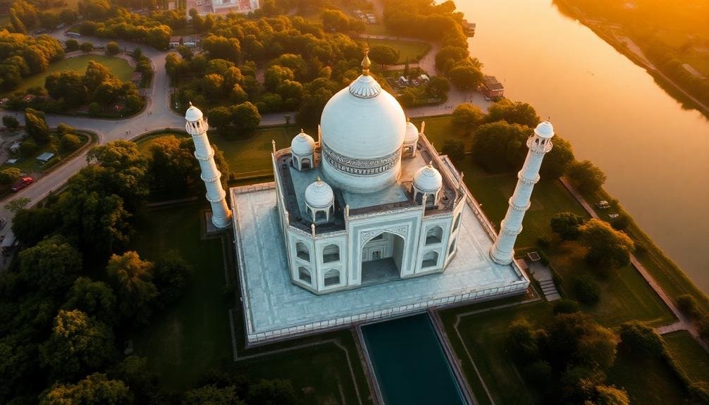
India's crown jewel shimmers in the sunlight as your drone ascends above the Taj Mahal. This iconic mausoleum, built by Mughal Emperor Shah Jahan in memory of his beloved wife, reveals its symmetrical beauty from above.
You'll notice the perfect alignment of gardens, waterways, and the main structure, all designed to create a harmonious paradise on Earth.
As your drone circles the monument, you'll capture stunning views of:
- The pristine white marble dome and minarets
- The intricate inlay work adorning the facades
- The reflecting pool that mirrors the Taj's image
- The red sandstone mosque and guest house flanking the mausoleum
From this aerial perspective, you'll appreciate the Taj Mahal's architectural precision and the vast scale of the complex.
The drone footage allows you to zoom in on details like the delicate pietra dura work and calligraphy that adorn the walls.
You'll also observe the carefully manicured Mughal gardens, their geometric patterns forming a striking contrast with the organic flow of the nearby Yamuna River.
This bird's-eye view offers a unique appreciation of the Taj Mahal's enduring beauty and its status as a masterpiece of world heritage.
Easter Island Moai
You'll be amazed by the aerial patterns of Easter Island's iconic Moai statues when seen from above.
From a drone's perspective, you can observe the strategic placement of these massive stone figures across the landscape.
You'll gain a new appreciation for the ancient Rapa Nui people's ingenuity as you witness the intricate layout and positioning of the Moai from this unique vantage point.
Aerial Patterns of Statues
Drones soaring above Easter Island reveal a fascinating aerial perspective of the iconic Moai statues.
You'll notice that these massive stone figures aren't randomly scattered across the landscape. Instead, they form distinct patterns and alignments that become apparent only from high above.
From a bird's-eye view, you can observe how the Moai are strategically placed along the island's coastline, facing inward towards the center of the island. This positioning suggests they were meant to protect and watch over the island's inhabitants.
You'll also spot clusters of statues near ancient village sites and ceremonial centers, hinting at their cultural and spiritual significance.
The aerial patterns of the Moai statues offer intriguing insights:
- Linear arrangements along ancient roads
- Concentric circles around sacred platforms
- Groupings that mirror celestial constellations
- Alignments with natural features like hills and bays
These patterns, invisible from ground level, provide valuable clues about the island's past.
They help archaeologists and researchers piece together the complex social structure, engineering prowess, and spiritual beliefs of the ancient Rapa Nui people who created these enigmatic stone sentinels.
Moai From Above Perspective
Occasionally, a bird's-eye view of Easter Island's Moai statues reveals details that ground-level observations miss entirely. From above, you'll notice the precise alignment of these ancient stone giants, often arranged in straight lines or curved formations that follow the island's topography.
You can see how the Moai are positioned to face inland, their backs to the sea, as if guarding the island's interior.
Drone footage allows you to appreciate the scale of these monumental figures in relation to their surroundings. You'll observe how the Moai interact with the landscape, some partially buried by centuries of soil accumulation, while others stand proud on their ahu platforms.
The aerial perspective highlights the quarry sites where the statues were carved, showing the unfinished Moai still attached to the bedrock.
From above, you can discern patterns in the distribution of the statues across the island, offering clues about ancient Rapa Nui social organization and land use.
The bird's-eye view also reveals the extent of erosion and environmental impact on these iconic figures, emphasizing the ongoing need for conservation efforts to preserve this unique cultural heritage.
Frequently Asked Questions
Are Drone Flights Legal at All These Ancient World Wonders?
You'll find drone regulations vary widely at ancient sites. Some allow flights with permits, while others ban them entirely. It's essential you check local laws and obtain necessary permissions before flying your drone at any world wonder.
What Type of Drone Is Best for Capturing These Aerial Views?
You'll want a drone with a high-quality camera, long battery life, and stable flight. DJI's Mavic series or Autel EVO II are great choices. They're easy to fly and capture stunning 4K footage for your aerial photography needs.
How High Can Drones Fly to Capture These Ancient Sites?
You'll find most consumer drones can fly up to 400 feet legally. However, for ancient sites, you're often restricted to lower altitudes. Check local regulations, as they vary by location and site significance.
Do You Need Special Permits to Film These Locations With Drones?
You'll likely need special permits to film with drones at ancient sites. Regulations vary by country and location, so you should research local laws beforehand. Many places restrict drone usage to protect privacy, safety, and cultural heritage.
What Time of Day Offers the Best Lighting for Drone Photography?
You'll find the best lighting for drone photography during the golden hour, just after sunrise or before sunset. It'll give you warm, soft light and long shadows. Avoid harsh midday sun for more flattering shots.
In Summary
You've just witnessed some of the world's most awe-inspiring ancient wonders from a unique aerial perspective. These drone views offer a fresh look at humanity's greatest architectural achievements. As you've seen, technology now allows us to appreciate these marvels in ways our ancestors never could. Next time you're planning a trip, consider seeking out these incredible sites. You'll gain a newfound appreciation for the ingenuity and artistry of ancient civilizations that continue to captivate us today.
As educators and advocates for responsible drone use, we’re committed to sharing our knowledge and expertise with aspiring aerial photographers.


Leave a Reply