When you view road trips from above, you'll witness a stunning tapestry of human ingenuity seamlessly woven into nature's canvas. Winding roads create mesmerizing patterns against diverse terrains, while bridges and tunnels add visual complexity. The interplay of light and shadow emphasizes textures and depth, especially during golden hours. Seasonal changes paint the landscape in ever-evolving hues, from spring's tender greens to autumn's fiery display. Unique geographical features like mountains, deserts, and coastlines provide dramatic backdrops. Traffic flow becomes a living, pulsing artery of light, revealing the rhythm of human movement. This bird's-eye perspective offers a fascinating glimpse into the artistry of our world's transportation networks.
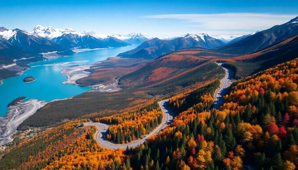
Winding Roads Through Landscapes
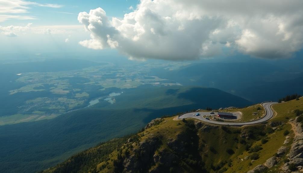
Anticipation builds as you gaze upon the sinuous ribbons of asphalt cutting through diverse terrains. From above, winding roads create a mesmerizing contrast against the natural landscape, offering a unique perspective on your journey.
You'll witness how these arteries of travel snake through lush forests, carve their way around towering mountains, and hug the coastlines of vast oceans.
The aerial view reveals the intricate patterns formed by hairpin turns and switchbacks as roads navigate challenging topography. You'll marvel at how engineers have designed these routes to blend seamlessly with the environment while providing safe passage.
The bird's-eye perspective allows you to appreciate the full scope of your adventure, from the starting point to your final destination.
As you observe these winding roads, you'll notice how they connect isolated communities, link urban centers, and provide access to remote natural wonders.
The contrast between man-made infrastructure and untamed wilderness creates an enthralling visual narrative, telling the story of human ingenuity and our enduring relationship with the land we traverse.
Contrasting Colors and Textures
You'll be amazed by the visual symphony created when complementary landscape elements collide in aerial road trip photos.
Nature's palette of forests, deserts, and waterways starkly contrasts with the geometric precision of man-made roads and bridges.
As the sun's position shifts, dramatic light and shadow play across these scenes, highlighting textures and creating enchanting compositions you won't soon forget.
Complementary Landscape Elements
Nature's color palette and textural contrasts play starring roles in aerial road trip photography. As you observe these scenes from above, you'll notice how various landscape elements work together to create stunning visual compositions.
Rivers and streams often wind through the terrain, providing a natural, curving counterpoint to the straight lines of roads. Their reflective surfaces catch the light, adding depth and dimension to the overall image.
Forests and fields create a patchwork effect, with different shades of green and gold interacting harmoniously. Rocky outcrops or desert formations can add rugged texture and interesting shapes, complementing the smooth asphalt of the roadways.
In coastal areas, the meeting of land and sea creates a dramatic boundary, with roads hugging cliffsides or stretching across bridges.
Urban elements like buildings, parks, and industrial zones can also contribute to the composition, offering a man-made contrast to natural features. Shadows cast by clouds or tall structures add another layer of visual interest, creating patterns that shift with the time of day and season.
These complementary landscape elements combine to transform ordinary road trips into extraordinary aerial spectacles.
Natural vs. Man-Made
One of the most enchanting aspects of aerial road trip photography is the stark contrast between natural and man-made elements. You'll notice how roads cut through landscapes, creating a striking visual interplay between human ingenuity and nature's raw beauty. The smooth, geometric lines of highways juxtapose against the organic shapes of forests, mountains, and rivers. This contrast isn't just visually appealing; it tells a story of human progress and our relationship with the environment.
As you observe these aerial views, you'll see how man-made structures often stand out boldly against natural backdrops. Bridges spanning wide rivers, tunnels burrowing through mountains, and winding roads hugging coastal cliffs all showcase humanity's determination to connect and explore.
This interplay between natural and artificial elements offers deeper insights:
- It highlights our ability to adapt to and shape our surroundings.
- It reminds us of the delicate balance between development and conservation.
- It showcases the beauty that can arise from the harmonious integration of human infrastructure with natural landscapes.
You'll find that the most enthralling aerial road trip images often masterfully capture this dance between the natural and the man-made.
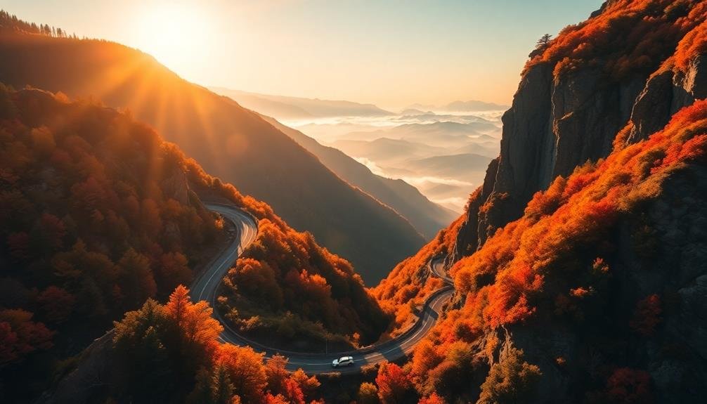
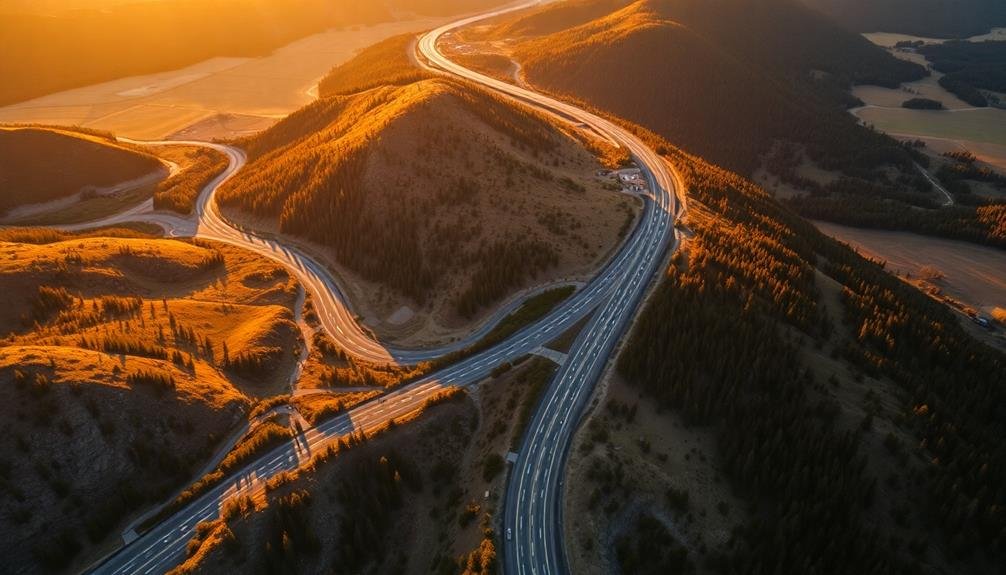
Dramatic Light and Shadow
Aerial road trip photography isn't just about capturing the interplay between natural and man-made elements; it's also about harnessing the power of light and shadow. As you plan your shots, consider the time of day and how it affects the landscape.
The golden hours—just after sunrise and before sunset—cast long shadows and bathe the scene in warm, golden light. This creates depth and drama, making roads and vehicles stand out against the terrain.
You'll want to pay attention to the angle of the sun relative to your subject. Side-lighting can emphasize textures and contours, while backlighting can create striking silhouettes.
Don't shy away from shooting during midday either. The harsh shadows can create bold, graphic compositions, especially when photographing winding roads through desert landscapes.
Cloud cover adds another dimension to your photos. Patchy clouds create a dynamic play of light and shadow across the land, adding interest to what might otherwise be a flat scene.
In overcast conditions, you'll find softer, more even lighting that can beautifully reveal the subtle colors and textures of the landscape.
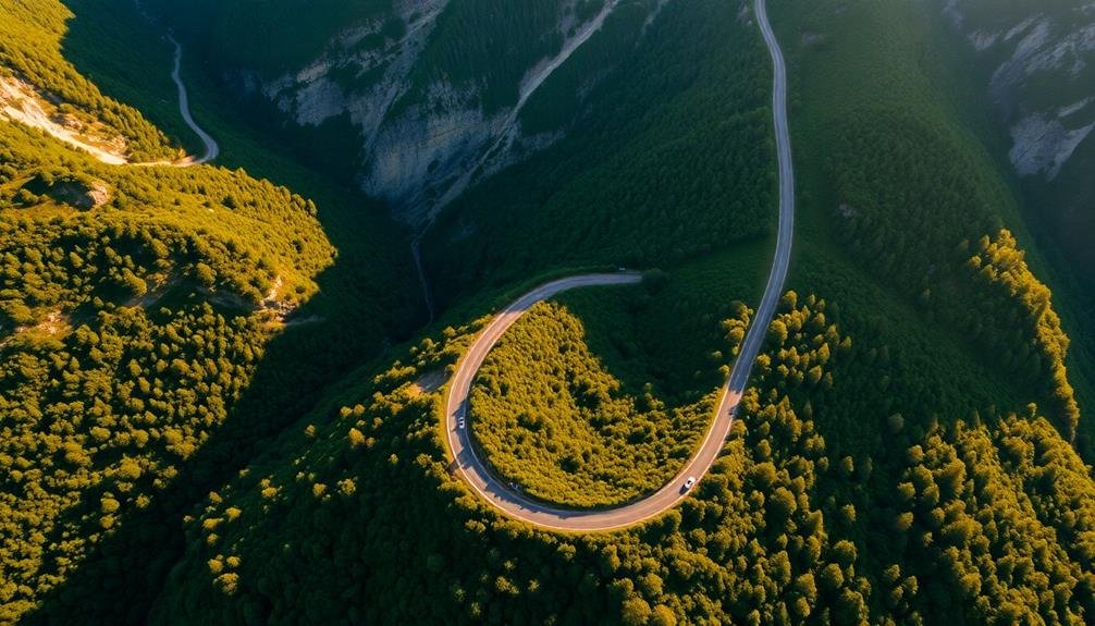
Symmetry and Patterns
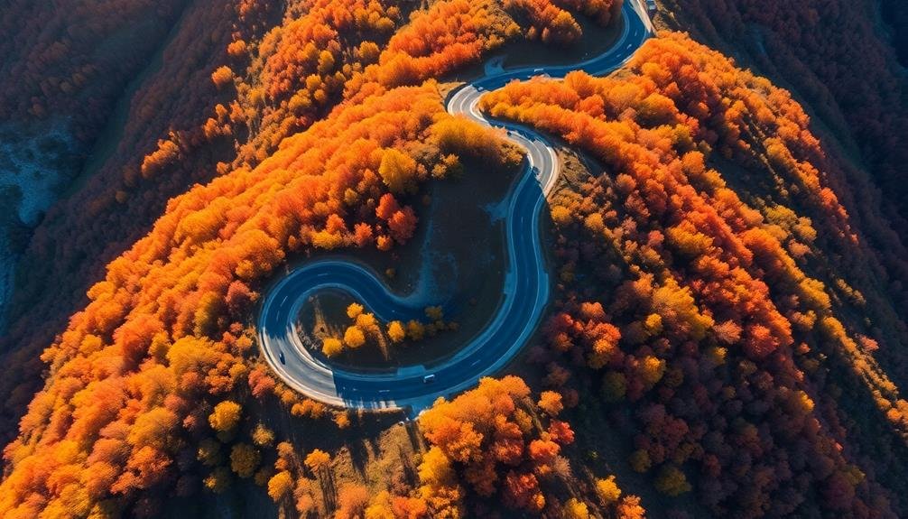
You'll notice striking geometric shapes emerging as you view road trips from above.
Repetitive landscape elements create mesmerizing patterns along your journey.
These aerial perspectives reveal a hidden symmetry in the world below, transforming familiar routes into abstract artworks.
Geometric Shapes Emerge
From high above, roads and highways transform into enchanting geometric patterns. You'll notice how straight lines intersect at perfect angles, creating grids that resemble circuit boards stretching across the landscape.
Curved roads carve elegant arcs and spirals into the terrain, while cloverleaf interchanges form intricate loops and circles. As you observe these aerial views, you'll discover that familiar routes take on entirely new forms.
Bridges become thin ribbons connecting landmasses, and tunnels disappear into mountainsides, only to reemerge as if by magic. The geometric shapes that emerge from this bird's-eye perspective offer a unique insight into human engineering and urban planning.
These enchanting aerial views of roads serve three important purposes:
- They highlight the intricate design and planning that goes into our transportation networks.
- They showcase the harmony between human-made structures and natural landscapes.
- They provide a fresh perspective on the scale and complexity of our interconnected world.
Repetitive Landscape Elements
As you scan the aerial landscape, repetitive elements begin to captivate your attention. You'll notice how certain features repeat themselves across vast stretches of land, creating mesmerizing patterns. These repetitive landscape elements contribute greatly to the stunning visual appeal of road trips from above.
Look for rows of crops in agricultural areas, where fields are neatly divided into geometric sections. You'll see how different crops create a patchwork of colors and textures.
In forested regions, you'll observe the repetitive pattern of treetops, forming a dense carpet of green that stretches for miles.
In urban areas, you'll spot the grid-like arrangement of streets and buildings, creating a rhythmic pattern of concrete and asphalt.
Along coastlines, you'll notice the repetitive crash of waves against the shore, forming intricate patterns in the sand.
Even natural landscapes showcase repetition. Desert dunes create rippling patterns across vast expanses, while mountain ranges display repeating peaks and valleys.
Rivers and streams meander through the landscape, their winding paths creating serpentine patterns that catch your eye from above.
Scale and Perspective
Magnitude takes on new meaning when viewing road trips from above. You'll be struck by the sheer vastness of the landscape and how roads seem to shrink into thin ribbons cutting through the terrain.
This aerial perspective completely transforms your perception of scale, making even the longest journeys appear condensed and manageable. From this vantage point, you'll notice how the curvature of the Earth becomes apparent, adding depth to your view.
Mountains that once towered over you now resemble small bumps, while sprawling cities become intricate patterns of light and shadow. This shift in perspective allows you to appreciate the true scope of your journey and the world around you.
The aerial view offers three key insights:
- It reveals the interconnectedness of landscapes and ecosystems
- It highlights the impact of human infrastructure on natural environments
- It provides a unique understanding of geographical features and their relationships
As you observe road trips from above, you'll gain a newfound appreciation for the intricate tapestry of our world and your place within it.
Natural and Man-Made Elements
The interplay between natural and man-made elements creates an enchanting visual symphony when viewed from above. You'll notice how roads wind through landscapes, cutting ribbons of asphalt across diverse terrains. These man-made arteries contrast sharply with the organic shapes of forests, rivers, and mountains, creating a mesmerizing juxtaposition.
From your aerial vantage point, you'll observe how human infrastructure integrates with nature. Bridges span wide rivers, tunnels burrow through mountains, and coastal highways hug cliffsides. These engineering marvels showcase humanity's ability to navigate and connect even the most challenging landscapes.
You'll also spot the patchwork of agricultural fields, their geometric patterns standing out against the irregular contours of the natural world. Cities and towns appear as clusters of buildings and streets, often following the path of least resistance dictated by the terrain.
The most stunning road trips from above often feature a harmonious blend of natural and artificial elements. You might see a solitary road snaking through a vast desert, or a network of highways converging on a bustling metropolis surrounded by pristine wilderness.
These scenes highlight the delicate balance between human progress and nature's timeless beauty.
Light and Shadow Play
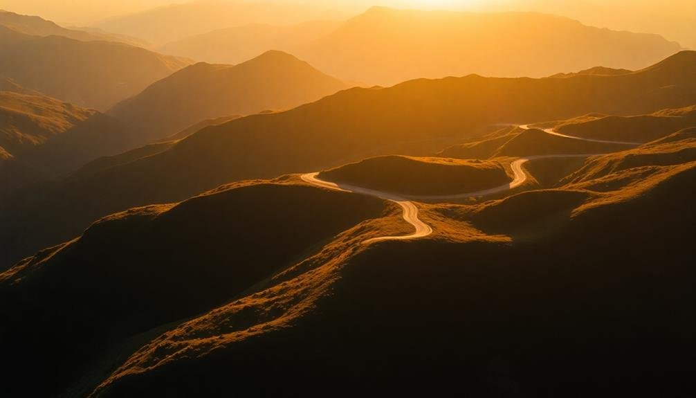
From your aerial perspective, light and shadow play an important role in transforming road trips into breathtaking visual spectacles. As you soar above, you'll notice how the sun's position dramatically alters the landscape below. Long shadows cast by mountains or tall structures create striking contrasts, emphasizing the road's winding path through diverse terrains.
During golden hour, you'll witness the warm glow that bathes everything in a magical light, turning ordinary scenes into extraordinary vistas.
Cloud cover adds another dimension to this interplay. You'll see how patches of sunlight break through, creating spotlights on specific areas of the journey. This ever-changing canvas keeps your aerial view dynamic and engaging.
At night, you'll observe a completely different spectacle as headlights trace the road's contours, creating ribbons of light against the darkness.
The light and shadow play serves three important purposes:
- Enhancing depth perception
- Highlighting unique landscape features
- Creating mood and atmosphere
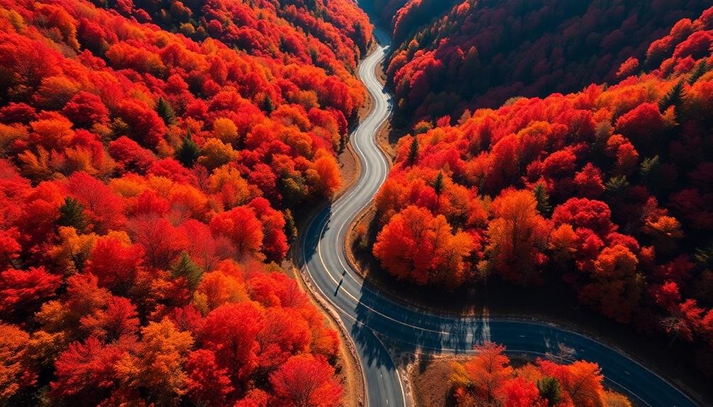
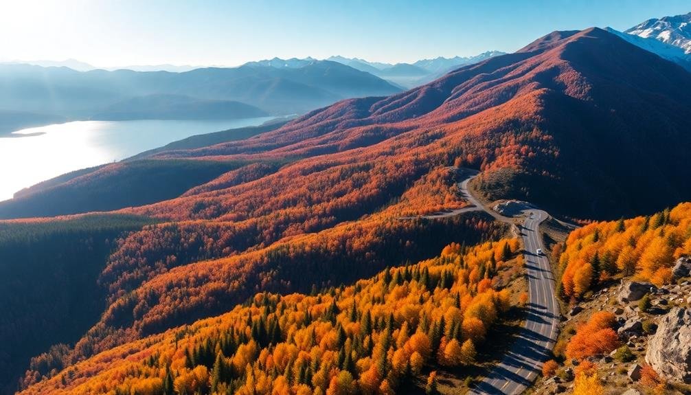
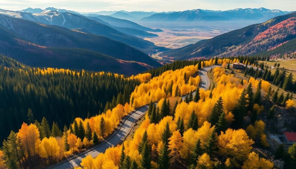
Seasonal Changes Along Routes
Seasonal transformations along road trip routes offer a constantly evolving spectacle from your aerial vantage point.
As you soar above, you'll witness nature's palette shift with each passing season, painting the landscape in vibrant hues.
In spring, you'll see a patchwork of tender greens and pastel blossoms unfurling along the roads.
Summer brings lush foliage and golden fields stretching to the horizon.
As autumn arrives, you're treated to a fiery display of reds, oranges, and yellows that set the route ablaze with color.
Winter's stark beauty reveals itself in snow-capped mountains and frost-covered forests, with winding roads cutting through pristine white landscapes.
Coastal routes showcase dramatic changes in water color and shoreline vegetation throughout the year.
You'll notice how these seasonal shifts affect not just the natural scenery, but also human activity along the routes.
Harvest time brings bustling farmlands, while winter may reveal ski resorts nestled in mountain passes.
Each season offers a unique perspective on the relationship between the road and its surroundings, creating an ever-changing visual narrative of your journey from above.
Unique Geographical Features
As you soar above stunning road trips, unique geographical features unfold beneath you like a natural tapestry.
You'll witness the Earth's diverse landscapes sculpted by time and nature. Winding roads slice through towering mountain ranges, revealing dramatic cliffs and cascading waterfalls. Coastal highways hug shorelines, offering glimpses of pristine beaches and rugged sea stacks.
In desert regions, you'll spot serpentine roads cutting across vast expanses of sand dunes and colorful rock formations. Lush forests give way to meandering rivers, their silvery threads weaving through valleys and canyons. You might even catch sight of volcanic landscapes, where roads skirt the edges of ancient calderas or traverse fields of cooled lava.
These unique geographical features not only create breathtaking views but also serve important purposes:
- They showcase Earth's geological history
- They provide habitats for diverse ecosystems
- They offer natural barriers and resources for human settlements
From above, you'll gain a new appreciation for how roads adapt to and showcase these remarkable landscapes, creating a harmonious blend of human engineering and nature's grandeur.
Traffic Flow Visualization
While you're taking in the stunning landscapes from above, you'll notice an intriguing pattern emerging on the roads below. This is traffic flow visualization, a mesmerizing sight that transforms ordinary highways into living arteries of light and movement.
From your aerial vantage point, you'll see streams of headlights and taillights creating fluid ribbons of illumination. During rush hours, these light trails intensify, forming pulsing veins of red and white that snake through the terrain. You'll observe how traffic ebbs and flows, with dense clusters at intersections and smoother streams along open stretches.
Time-lapse photography enhances this spectacle, compressing hours of traffic into seconds. You'll witness day turning to night as street lamps flicker on, adding a new dimension to the visual tapestry.
In urban areas, you'll spot intricate webs of light forming complex patterns, while rural roads offer more isolated, tranquil streams.
This bird's-eye view of traffic flow isn't just visually striking; it's also a powerful tool for urban planners and traffic engineers. By observing these patterns, they can identify bottlenecks, optimize traffic light timing, and improve overall road efficiency.
Frequently Asked Questions
What Camera Equipment Is Best for Aerial Road Trip Photography?
You'll want a high-resolution drone with a quality camera for aerial road trip photography. Look for models with long battery life, GPS capabilities, and obstacle avoidance. Don't forget extra batteries and memory cards for extended shooting sessions.
Are There Legal Restrictions for Drone Photography Over Highways?
Yes, there are legal restrictions for drone photography over highways. You'll need to follow FAA regulations, including maintaining visual line of sight, staying below 400 feet, and avoiding restricted airspace. Always check local laws before flying near roads.
How Can I Find the Most Photogenic Road Trip Routes?
To find photogenic road trip routes, you'll want to research scenic byways, coastal drives, and mountain passes. Use travel blogs, photography sites, and social media for inspiration. Don't forget to check national parks and iconic landmarks along your potential routes.
What Time of Day Offers the Best Lighting for Aerial Road Shots?
You'll capture the most stunning aerial road shots during the golden hour, just after sunrise or before sunset. The warm, soft light creates long shadows and enhances colors, making roads and landscapes pop beautifully from above.
How Do Weather Conditions Affect Aerial Road Trip Photography?
Weather conditions greatly impact your aerial road trip photos. You'll find clouds add drama, clear skies enhance colors, and rain creates reflective surfaces. Fog can create mystical scenes, while snow offers stunning contrast. Always check forecasts before flying.
In Summary
You've seen how road trips transform when viewed from above. They're no longer just journeys, but art pieces etched into the landscape. You'll notice winding paths, vibrant contrasts, and mesmerizing patterns you'd miss from the ground. The interplay of light, shadow, and seasons adds depth to these aerial vistas. Whether it's natural wonders or man-made marvels, you're witnessing a unique perspective that turns ordinary routes into extraordinary sights. Next time you're traveling, look up – you might be part of a stunning aerial canvas.
As educators and advocates for responsible drone use, we’re committed to sharing our knowledge and expertise with aspiring aerial photographers.


Leave a Reply