
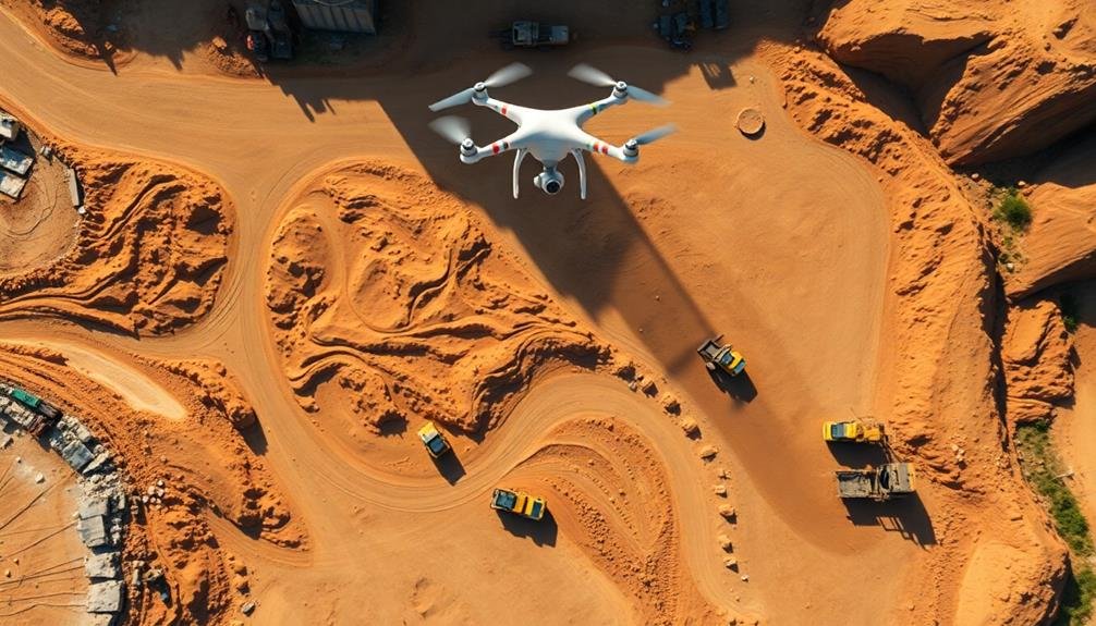
You'll revolutionize your construction projects with these top drone techniques for earthwork calculations. Employ photogrammetry for accurate volume assessments and LiDAR for precise measurements. Create orthomosaic maps for thorough site analysis, and use RTK GPS for pinpoint positioning. Implement automated flight planning to optimize data collection. Generate detailed point clouds and leverage thermal imaging for material insights. Harness AI-powered workflows to streamline data processing, and visualize your earthworks with 3D modeling. By mastering these cutting-edge methods, you'll boost efficiency, reduce errors, and stay ahead of the competition. Dive deeper to access the full potential of drone technology in construction.
Photogrammetry for Volume Calculations

Photogrammetry stands at the forefront of modern earthwork calculations. This technique uses overlapping aerial images captured by drones to create highly accurate 3D models of construction sites. You'll find that these models provide precise measurements for cut and fill volumes, stockpile quantities, and terrain contours.
To implement photogrammetry effectively, you'll need to plan your drone flight carefully. Ascertain your flight path covers the entire area of interest with at least 70% overlap between images. You'll want to maintain a consistent altitude and use a high-resolution camera for best results.
Once you've collected the images, specialized software processes them to generate a point cloud and mesh model. From this model, you can extract volume calculations with remarkable accuracy. You'll be able to compare surveys from different dates to track progress and calculate material movement.
This method considerably reduces the time and labor required for traditional ground-based surveys. It's particularly useful for large or complex sites where manual measurements would be impractical. By leveraging photogrammetry, you'll streamline your earthwork calculations and improve overall project efficiency.
LiDAR Integration for Precise Measurements

Often, LiDAR technology takes drone-based surveying to the next level of precision. By integrating LiDAR sensors into your drone setup, you'll capture highly accurate 3D point clouds of the construction site. These point clouds provide detailed terrain information, even in areas with dense vegetation or complex structures.
LiDAR's ability to penetrate through foliage and capture ground-level data makes it invaluable for earthwork calculations in challenging environments. You'll obtain more precise measurements of soil volumes, cut-and-fill estimates, and stockpile quantities. The technology's rapid data collection allows you to survey large areas quickly, reducing on-site time and increasing overall efficiency.
When using LiDAR for earthwork calculations, you'll benefit from its centimeter-level accuracy. This precision is vital for complex projects where even small measurement errors can lead to significant cost overruns. You can also create highly detailed digital terrain models (DTMs) and contour maps, which are essential for optimizing site grading and drainage plans.
To maximize LiDAR's potential, guarantee proper calibration and flight planning. Consider factors like flying height, speed, and scan angle to achieve the desired point density and coverage.
Orthomosaic Mapping for Site Analysis
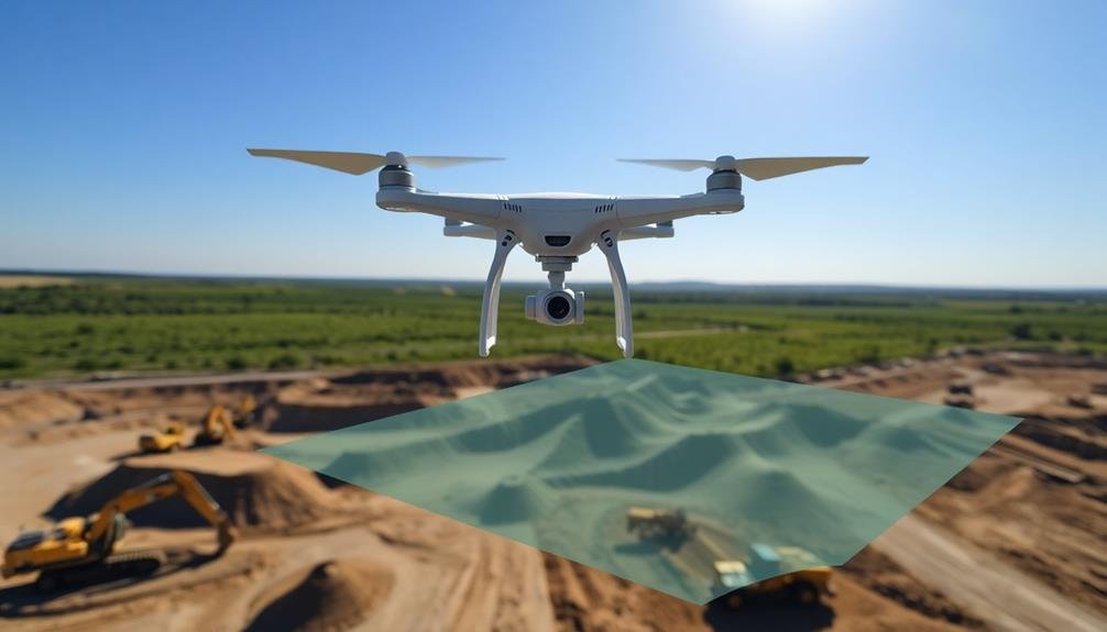
Drones' ability to create orthomosaic maps has revolutionized site analysis for earthwork projects. These high-resolution, distortion-free aerial images provide a thorough view of your construction site, allowing for accurate measurements and detailed planning.
To create an orthomosaic map, you'll need to fly your drone in a grid pattern over the area of interest, capturing overlapping images. Specialized software then stitches these images together, correcting for perspective and creating a single, large-scale image that's geometrically accurate.
You can use orthomosaic maps to identify site features, measure distances and areas, and plan earthwork operations. They're particularly useful for calculating cut and fill volumes, determining ideal equipment routes, and identifying potential obstacles or hazards.
When combined with digital elevation models (DEMs), orthomosaic maps become even more powerful. You can create 3D models of your site, allowing for more precise volume calculations and better visualization of the proposed earthwork.
For best results, verify your drone is equipped with a high-quality camera and GPS system. Fly at a consistent altitude and maintain significant image overlap (70-80%) to guarantee accurate stitching.
Regular updates of your orthomosaic map throughout the project will help you track progress and make informed decisions.
RTK GPS for Accurate Positioning
While orthomosaic mapping provides an excellent overview of your site, RTK GPS technology takes drone-based earthwork calculations to the next level of precision. RTK (Real-Time Kinematic) GPS systems allow your drone to achieve centimeter-level accuracy in its positioning data. This enhanced precision is essential for accurate volume calculations and detailed site analysis.
When you're using RTK GPS for earthwork calculations, you'll benefit from:
- Improved accuracy: RTK GPS reduces the margin of error in your measurements, ensuring more reliable data for decision-making.
- Real-time corrections: The system continuously adjusts for atmospheric interference and satellite positioning, providing up-to-date information.
- Faster data processing: With more precise initial data, you'll spend less time post-processing and correcting errors.
To implement RTK GPS in your drone surveys, you'll need a compatible drone and a base station on the ground. The base station communicates with the drone in real-time, correcting any positioning errors.
This setup allows you to create highly accurate 3D models and contour maps of your construction site, giving you the confidence to make informed decisions about earthwork volumes and site grading.
Automated Flight Planning Techniques

Automated flight planning techniques have revolutionized the way we approach drone surveys for earthwork calculations. These advanced methods allow you to create efficient, precise flight paths for your drone, ensuring thorough coverage of the construction site.
You'll start by importing your site boundaries into specialized flight planning software. This software will automatically generate a suitable flight path, taking into account factors like altitude, overlap percentage, and camera settings. You can adjust these parameters to fine-tune the survey based on your specific project requirements.
Many automated flight planning tools offer terrain-aware features, which adjust the drone's altitude to maintain a consistent ground sampling distance across uneven terrain. This is vital for accurate earthwork calculations in hilly or varied landscapes.
You'll also find options for obstacle avoidance and no-fly zones, helping you navigate around structures or restricted areas. Some advanced systems even integrate with weather APIs, suggesting ideal flight times based on wind and lighting conditions.
Multi-Temporal Surveys for Progress Tracking
You'll find multi-temporal surveys invaluable for tracking earthwork progress over time.
By conducting frequent site monitoring, you can assess volume changes and compare project timelines visually.
These surveys enable you to quantify excavation or fill progress, identify potential delays, and make data-driven decisions to keep your project on schedule.
Frequent Site Monitoring
Keeping tabs on earthwork progress is a breeze with frequent drone surveys. You'll gain real-time insights into your project's status, allowing for quick decision-making and problem-solving.
By conducting regular flights, you can track changes in terrain, material volumes, and overall site conditions with unprecedented accuracy.
Frequent site monitoring offers several key advantages:
- Early detection of discrepancies between planned and actual earthwork volumes
- Improved scheduling and resource allocation based on up-to-date progress data
- Enhanced safety by identifying potential hazards or unstable areas before they become critical
You'll find that weekly or bi-weekly drone surveys provide a preferable balance between data freshness and operational efficiency.
This frequency allows you to capture significant changes while minimizing disruptions to ongoing work. As you analyze the collected data, you'll be able to spot trends, adjust timelines, and enhance your earthwork operations.
Volume Change Assessment
Volume change assessment is a powerful tool for tracking earthwork progress over time. By conducting multi-temporal surveys with drones, you can accurately measure changes in soil volume and assess the progress of excavation or filling activities. This technique involves comparing 3D models generated from drone data collected at different stages of your project.
To perform volume change assessments, you'll need to capture high-resolution aerial imagery and use photogrammetry software to create detailed digital terrain models (DTMs). Guarantee you maintain consistent flight parameters and ground control points across surveys for accurate comparisons.
Once you've generated DTMs for different time periods, you can use specialized software to calculate volume differences between them. This method allows you to quantify the amount of material moved, identify areas of significant change, and verify if earthwork is progressing according to plan.
You'll be able to detect discrepancies early, adjust schedules if needed, and provide stakeholders with precise progress reports. Volume change assessment also helps in managing resources efficiently by determining exact quantities of material required or removed.
Timeline Comparison Visualization
Timeline comparison visualization is a powerful technique that leverages multi-temporal drone surveys to track earthwork progress visually. By conducting regular drone flights over your construction site, you'll generate a series of orthomosaic maps and 3D models that can be compared side-by-side or overlaid to highlight changes over time.
This method offers several advantages for project managers and stakeholders:
- Rapid progress assessment: You can quickly identify areas of significant change, allowing for immediate evaluation of work completed between surveys.
- Enhanced communication: Visual timelines make it easier to convey project status to clients, team members, and other stakeholders without relying solely on technical data.
- Trend analysis: By examining multiple surveys in sequence, you'll spot patterns in work rates and potentially identify bottlenecks or efficiency improvements.
To implement timeline comparison visualization effectively, establish a consistent flight schedule and guarantee your drone captures high-quality imagery with sufficient overlap.
Use specialized software to process and align your surveys, creating a seamless visual narrative of your project's evolution. This approach not only streamlines progress tracking but also provides valuable insights for future planning and resource allocation in earthwork projects.
Point Cloud Generation Methods
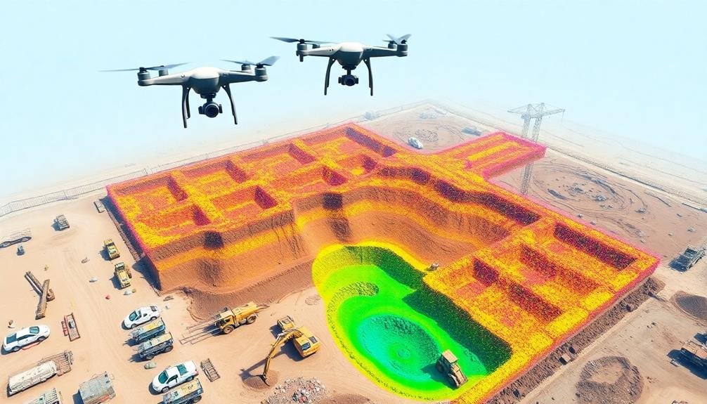
Over the past decade, point cloud generation methods have revolutionized earthwork calculations in the drone industry. You'll find two primary techniques for creating point clouds: photogrammetry and LiDAR.
Photogrammetry uses overlapping images captured by drones to create 3D models. You'll need to fly your drone in a grid pattern, ensuring at least 70% overlap between images. Software then analyzes these photos, identifying common points to reconstruct the terrain in 3D.
This method is cost-effective and works well in most conditions, but it can struggle with vegetation or reflective surfaces.
LiDAR, on the other hand, uses laser pulses to measure distances and create highly accurate 3D models. You'll equip your drone with a LiDAR sensor, which emits rapid laser pulses as it flies.
These pulses bounce off surfaces and return to the sensor, allowing for precise distance calculations. LiDAR excels in areas with dense vegetation or complex structures, but it's typically more expensive than photogrammetry.
To choose the best method for your project, consider factors like terrain complexity, budget, and required accuracy. Some projects may benefit from combining both techniques for ideal results.
Thermal Imaging for Material Analysis
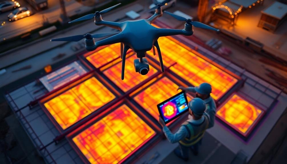
Thermal imaging drones offer you powerful insights into earthwork materials through temperature variation detection.
You'll be able to identify different soil types, moisture content, and compaction levels based on their heat signatures.
This technology also enables you to assess material composition, helping you make informed decisions about excavation, fill, and overall project planning.
Temperature Variation Detection
In recent years, drone-equipped thermal imaging cameras have revolutionized earthwork calculations by enabling temperature variation detection. You can now identify subtle temperature differences across a construction site, providing valuable insights into soil composition, moisture content, and material properties.
By utilizing temperature variation detection, you'll be able to:
- Detect subsurface anomalies that may affect excavation or foundation work
- Identify areas of poor drainage or water accumulation
- Assess the compaction and density of soil layers
This technology allows you to make more informed decisions about earthwork processes, potentially saving time and resources. You'll be able to pinpoint areas that require additional attention or treatment before proceeding with construction activities.
Temperature variation detection also helps you monitor the curing process of concrete structures, ensuring ideal strength development. By identifying hot spots or cold areas, you can adjust curing conditions to achieve uniform results.
As you integrate this technique into your earthwork calculations, you'll find that it complements other drone-based surveying methods, providing a thorough understanding of site conditions.
This holistic approach enhances the accuracy of volume estimates and improves overall project planning and execution.
Material Composition Assessment
Building on the thermal imaging capabilities used for temperature variation detection, you can extend this technology to assess material composition across your construction site.
Thermal drones equipped with specialized sensors can identify different materials based on their unique heat signatures and emissivity properties. This technique allows you to distinguish between soil types, aggregates, and even man-made materials like concrete or asphalt.
To effectively use thermal imaging for material composition assessment, you'll need to calibrate your drone's sensors for the specific materials present on your site.
Create a reference library of thermal signatures for common construction materials and soil types. When conducting surveys, fly your drone in a grid pattern at a consistent altitude to guarantee uniform data collection.
Process the captured thermal images using specialized software that can analyze and classify materials based on their thermal properties.
This method proves particularly useful for large-scale earthwork projects, where understanding the distribution of various materials is essential for accurate volume calculations and project planning.
You can quickly identify areas with different soil compositions, locate buried objects, or detect moisture content variations that might affect excavation or compaction processes.
AI-Powered Data Processing Workflows

AI-powered data processing workflows have revolutionized earthwork calculations using drone imagery. These advanced systems streamline the process of converting raw drone data into actionable insights for construction projects.
You'll find that AI algorithms can quickly analyze vast amounts of aerial imagery, point clouds, and other data types to generate accurate 3D models and volumetric calculations.
To leverage AI-powered workflows effectively, you should:
- Confirm your drone captures high-quality, consistent data
- Choose software that integrates seamlessly with your existing tools
- Regularly update and calibrate your AI models for peak performance
3D Modeling for Visualizing Earthworks

3D modeling brings earthwork projects to life, offering a powerful visualization tool for construction teams. You'll find that these models, created from drone-captured data, provide an immersive view of your site's topography and proposed changes.
By leveraging 3D modeling software, you can easily manipulate and analyze the terrain, allowing for more accurate planning and decision-making. You'll be able to simulate various earthwork scenarios, such as cut-and-fill operations, in real-time. This capability helps you optimize your project's design and identify potential issues before breaking ground.
3D models also enhance communication among stakeholders, as you can present complex earthwork concepts in an easily digestible visual format. Moreover, you can use these models to track progress throughout the project. By comparing updated 3D models against the original plans, you'll quickly spot discrepancies and make necessary adjustments.
This approach greatly reduces the risk of costly errors and guarantees your project stays on schedule. To maximize the benefits of 3D modeling, it's essential to invest in high-quality drone data collection and processing. You'll want to confirm your team is well-trained in interpreting and utilizing these models effectively.
Frequently Asked Questions
How Do Weather Conditions Affect Drone Performance During Earthwork Calculations?
Weather conditions greatly impact your drone's performance. Wind can affect stability and flight patterns. Rain or snow may damage sensors. Extreme temperatures can reduce battery life. Poor visibility from fog or heavy cloud cover hinders accurate data collection.
What Are the Legal Requirements for Using Drones in Construction Sites?
You'll need to obtain a Part 107 license from the FAA, follow local regulations, and secure permission from property owners. Don't forget to register your drone and maintain insurance coverage. Always prioritize safety and privacy concerns.
How Long Does It Take to Process Drone Data for Earthwork Calculations?
You'll find that processing drone data for earthwork calculations typically takes a few hours to a day. It depends on the site's size, data complexity, and your software's efficiency. You can often get same-day results.
Can Drones Be Used for Underwater or Subterranean Earthwork Measurements?
You can use specialized underwater drones for submerged earthwork measurements. They're equipped with sonar and cameras. For subterranean work, you'll need ground-penetrating radar or LiDAR systems, often mounted on terrestrial vehicles rather than aerial drones.
What Are the Cost Comparisons Between Traditional Surveying Methods and Drone Techniques?
You'll find drone techniques are often more cost-effective than traditional surveying methods. They're faster, require fewer personnel, and cover larger areas quickly. However, initial equipment costs can be higher, so consider your project's scale and frequency.
In Summary
You've now got a powerful toolkit of drone techniques for earthwork calculations. By mastering these methods, you'll revolutionize your construction projects. Remember, it's not just about flying drones; it's about leveraging cutting-edge technology to make smarter decisions. Whether you're calculating volumes, creating 3D models, or analyzing materials, these techniques will save you time and money. Keep exploring and refining your skills to stay ahead in the ever-evolving world of construction technology.
As educators and advocates for responsible drone use, we’re committed to sharing our knowledge and expertise with aspiring aerial photographers.


Leave a Reply