You can detect algal blooms from above using a variety of cutting-edge techniques. Multispectral and hyperspectral imagery analysis pinpoint unique spectral signatures of algae. Thermal infrared sensing spots temperature anomalies associated with blooms. LiDAR mapping provides high-resolution surface data, while machine learning algorithms process complex datasets for accurate identification. Time-series image comparison tracks bloom development over time. Chlorophyll fluorescence detection, polarimetric imaging, and water color index calculations offer additional insights. Drone-mounted spectroradiometers enable rapid, high-resolution data collection. These methods revolutionize environmental monitoring, allowing you to spot ecological threats with unprecedented precision and speed. Explore further to reveal the full potential of these advanced detection techniques.
Multispectral Imagery Analysis
Multispectral imagery analysis is a powerful tool for detecting algal blooms. You'll find it invaluable for monitoring large water bodies from satellites or aircraft. This technique uses sensors to capture data across multiple spectral bands, including visible light and near-infrared wavelengths.
To detect algal blooms, you'll focus on the unique spectral signatures of chlorophyll and other pigments found in algae. These signatures differ from those of clear water or other substances. You'll analyze reflectance patterns in the blue, green, and red portions of the visible spectrum, as well as the near-infrared region.
You'll use specialized software to process the imagery, applying algorithms that highlight areas with high chlorophyll concentrations. These algorithms can help you distinguish between different types of algae and estimate bloom intensity.
You'll also compare images over time to track bloom development and movement.
Thermal Infrared Sensing

Thermal infrared sensing offers a powerful tool for detecting algal blooms through temperature anomaly detection.
You'll find that warmer water temperatures often indicate the presence of algal blooms, allowing you to quickly identify potential outbreak areas.
Temperature Anomaly Detection
One of the most effective methods for detecting algal blooms is through temperature anomaly detection using thermal infrared sensing. This technique allows you to identify areas where water temperatures deviate from expected values, often indicating the presence of algal blooms.
You'll use thermal infrared sensors mounted on satellites or aircraft to measure the sea surface temperature (SST) across large areas. These sensors detect the infrared radiation emitted by the water's surface, which correlates with its temperature. By comparing the observed temperatures to historical averages or surrounding waters, you can spot anomalies.
Algal blooms typically cause localized increases in water temperature due to increased absorption of sunlight and metabolic activity. You'll look for patches of warmer water that stand out from their surroundings.
It's important to take into account factors like time of day, season, and weather conditions when interpreting these anomalies.
Temperature anomaly detection is particularly useful for early bloom detection and monitoring their progression. You can track the spread and intensity of blooms over time by analyzing temperature patterns.
This method works well in conjunction with other remote sensing techniques for thorough algal bloom monitoring.
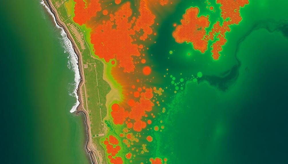
Bloom Extent Mapping
Building on temperature anomaly detection, bloom extent mapping using thermal infrared sensing allows you to visualize and quantify the spatial distribution of algal blooms. This technique leverages the unique thermal signatures of algal blooms, which often differ from surrounding water temperatures.
By analyzing thermal infrared imagery, you can identify areas with higher concentrations of algae and map their extent across water bodies.
To effectively map bloom extent using thermal infrared sensing, you'll need to:
- Acquire high-resolution thermal infrared imagery of the target area
- Calibrate the imagery to account for atmospheric effects
- Apply image processing algorithms to enhance contrast and identify thermal anomalies
- Use classification techniques to delineate bloom boundaries
This approach offers several advantages over traditional methods. It's non-invasive, covers large areas quickly, and can detect blooms at various depths.
You can also track bloom development over time by comparing sequential images. However, it's essential to recognize that thermal infrared sensing may have limitations in certain conditions, such as cloudy weather or when blooms are in their early stages.
Combining this technique with other remote sensing methods can provide a more thorough understanding of algal bloom dynamics.
Hyperspectral Remote Sensing
Hyperspectral remote sensing offers you powerful tools for detecting algal blooms through detailed spectral analysis.
You'll find it particularly effective in identifying specific algal pigments, which serve as unique spectral signatures for different types of algae.
This technology also enables you to assess overall water quality by analyzing various wavelengths reflected from the water's surface, providing an extensive view of the aquatic environment.
Spectral Signature Identification
Advancements in remote sensing technology have revolutionized the detection of algal blooms through spectral signature identification. You'll find that each type of algae has a unique spectral signature, which is like a fingerprint in the electromagnetic spectrum. By analyzing these signatures, you can identify and monitor algal blooms with remarkable accuracy.
To effectively use spectral signature identification, you'll need to:
- Collect hyperspectral data using advanced sensors
- Process the data to remove atmospheric interference
- Compare the collected spectra with known algal signatures
- Apply machine learning algorithms for automatic classification
You'll discover that this technique allows for early detection of algal blooms, even before they're visible to the naked eye. It's particularly useful for identifying potentially harmful algal species that may pose risks to ecosystems and human health.
Algal Pigment Detection
Algal pigments hold the key to revealing precise bloom detection through hyperspectral remote sensing. You'll find that these pigments, like chlorophyll-a, phycocyanin, and phycoerythrin, absorb and reflect light at specific wavelengths. By analyzing these unique spectral signatures, you can identify different types of algae and estimate their concentrations.
Hyperspectral sensors capture data across hundreds of narrow, contiguous bands in the electromagnetic spectrum. This high spectral resolution allows you to detect subtle changes in pigment composition that might be missed by broader-band sensors. You'll need to focus on key absorption features, such as the chlorophyll-a peak at 680 nm or the phycocyanin absorption around 620 nm.
To effectively use this technique, you should:
- Calibrate your sensors carefully to guarantee accurate measurements.
- Apply atmospheric correction algorithms to remove interference from water vapor and aerosols.
- Use spectral unmixing techniques to separate algal signals from background noise.
- Develop region-specific algorithms that account for local water conditions.
- Validate your results with in-situ measurements for improved accuracy.
Water Quality Assessment
Remote sensing's powerhouse, hyperspectral imaging, isn't just for algal bloom detection—it's a game-changer for thorough water quality assessment.
You'll find it's an invaluable tool for analyzing various water parameters simultaneously. With its ability to capture hundreds of narrow spectral bands, hyperspectral sensors can detect subtle changes in water composition that other methods might miss.
You can use hyperspectral data to assess:
- Turbidity levels
- Dissolved organic matter concentrations
- Chlorophyll-a content
- Suspended sediment loads
These indicators provide an extensive picture of water quality. You'll be able to identify potential pollutants, monitor nutrient levels, and track changes in aquatic ecosystems over time.
Hyperspectral imaging also allows you to create detailed maps of water bodies, highlighting areas of concern and guiding targeted interventions.
LiDAR-Based Water Surface Mapping

While traditional methods of algal bloom detection rely heavily on satellite imagery, LiDAR-based water surface mapping has emerged as a powerful complementary technique. You'll find that LiDAR technology offers high-resolution, three-dimensional data on water surface characteristics, enabling more accurate detection of algal blooms.
LiDAR systems emit laser pulses and measure the time it takes for the light to return, creating detailed topographic maps. When applied to water surfaces, LiDAR can detect subtle changes in elevation, texture, and reflectivity that may indicate the presence of algal blooms. You can use airborne LiDAR systems mounted on aircraft or drones to survey large areas quickly and efficiently.
One of the key advantages of LiDAR-based mapping is its ability to penetrate through atmospheric conditions that might obstruct satellite imagery. You'll be able to gather data even on cloudy days or in hazy conditions.
Additionally, LiDAR can provide information on water depth and bottom topography, which can be essential for understanding the environmental factors contributing to algal bloom formation.
To maximize the effectiveness of LiDAR-based water surface mapping, you should combine it with other remote sensing techniques and in-situ measurements for a thorough approach to algal bloom detection and monitoring.
Machine Learning Algorithms

You'll find that machine learning algorithms have revolutionized algal bloom detection.
Supervised classification techniques allow you to train models on labeled data, enabling accurate identification of bloom patterns.
Deep learning applications, such as convolutional neural networks, can extract complex features from satellite imagery and in-situ sensor data, enhancing your ability to predict and monitor algal blooms.
Supervised Classification Techniques
As we explore supervised classification techniques, it's important to understand their essential role in detecting algal blooms. These methods rely on labeled training data to create models that can accurately identify and classify algal blooms in satellite imagery.
You'll find that supervised classification algorithms, such as Support Vector Machines (SVM) and Random Forests, are particularly effective in this scenario.
To implement supervised classification for algal bloom detection, you'll typically follow these steps:
- Collect and prepare a diverse set of labeled satellite images
- Extract relevant features from the images, such as color, texture, and spectral information
- Train your chosen algorithm using the labeled data
- Apply the trained model to new, unlabeled images for classification
You'll need to take into account factors like water turbidity, atmospheric conditions, and sensor characteristics when selecting features for your model.
It's vital to regularly update and refine your training data to account for seasonal variations and changes in algal bloom patterns.
Deep Learning Applications
Harnessing the power of deep learning has revolutionized algal bloom detection techniques. You'll find that these advanced algorithms can process vast amounts of satellite imagery and sensor data with remarkable accuracy. Convolutional Neural Networks (CNNs) are particularly effective for analyzing spatial patterns in remote sensing images, allowing you to identify algal blooms across large water bodies.
Here's a comparison of popular deep learning models for algal bloom detection:
| Model | Strengths | Limitations |
|---|---|---|
| CNNs | Excellent at spatial pattern recognition | Requires large labeled datasets |
| RNNs | Can process time-series data effectively | May struggle with long-term dependencies |
| GANs | Can generate synthetic training data | Complex to train and optimize |
You'll want to take into account using transfer learning techniques to overcome the challenge of limited labeled data in algal bloom detection. By fine-tuning pre-trained models on your specific dataset, you can achieve high accuracy with fewer training examples. Additionally, you should explore ensemble methods that combine multiple deep learning models to improve overall detection performance. Remember to regularly update your models with new data to guarantee they remain effective as environmental conditions change over time.
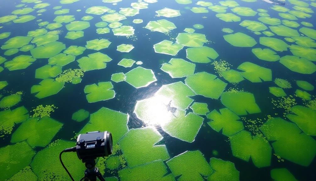
Drone-Mounted Spectroradiometers

Drone-mounted spectroradiometers represent a cutting-edge approach to detecting algal blooms. These innovative devices allow you to collect high-resolution spectral data from above, providing vital information about water quality and algal presence.
By attaching a spectroradiometer to a drone, you can cover large areas quickly and efficiently, accessing even remote or hard-to-reach water bodies.
When using drone-mounted spectroradiometers, you'll benefit from:
- Real-time data collection
- Reduced labor costs compared to traditional sampling methods
- Increased spatial coverage and temporal resolution
- Minimal disturbance to aquatic ecosystems
To effectively use this technology, you'll need to calibrate your equipment properly and verify you're flying at the best altitude for data collection.
It's important to take into account factors such as sun angle, wind speed, and surface reflectance when planning your flights.
By analyzing the spectral signatures captured by the drone-mounted spectroradiometer, you can identify different types of algae and estimate their concentrations.
This information is invaluable for early detection of harmful algal blooms, allowing for timely intervention and management strategies to protect water resources and public health.
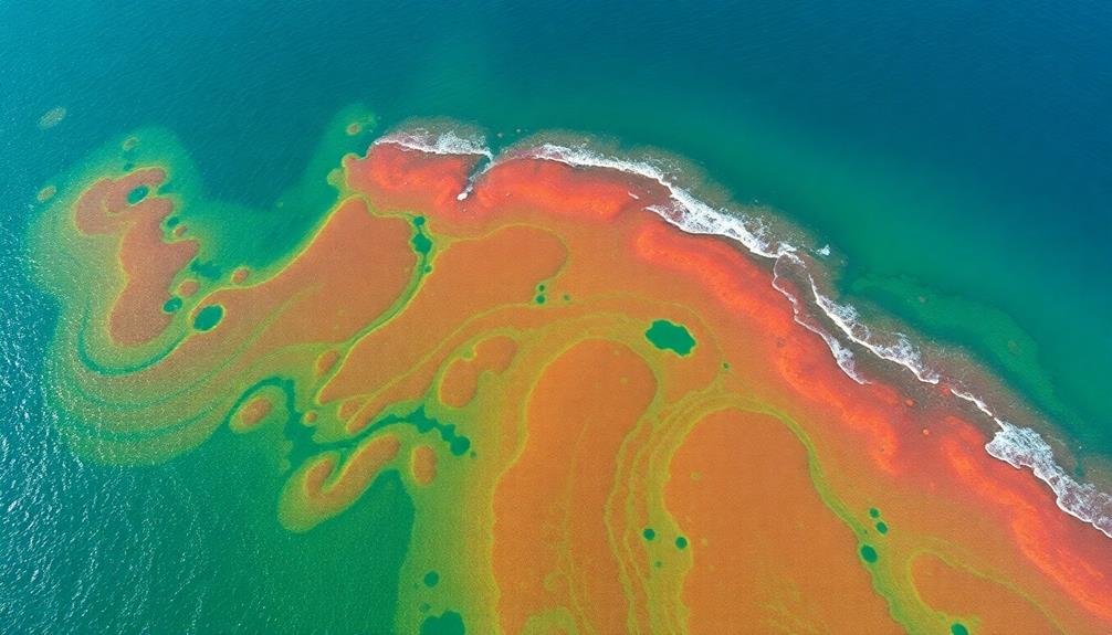
Time-Series Image Comparison
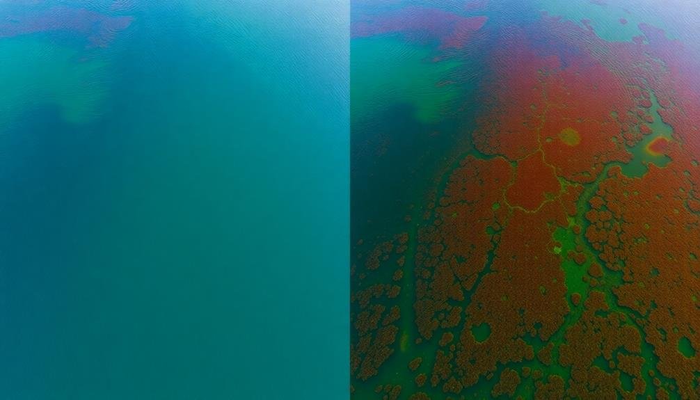
In addition to drone-based techniques, time-series image comparison stands out as a powerful method for detecting algal blooms. This approach involves analyzing multiple images of the same water body taken over time to identify changes in color, texture, and patterns that may indicate the presence of algae.
You'll typically use satellite imagery or aerial photographs for this technique. By comparing images captured days, weeks, or even months apart, you can spot the development and progression of algal blooms. Look for shifts in water color from blue to green or reddish-brown, which often signal algal growth.
Advanced software tools can help you automate this process, using algorithms to detect subtle changes that might be missed by the human eye. These programs can analyze hundreds of images quickly, flagging potential bloom areas for further investigation.
Time-series comparisons also allow you to track the size and movement of blooms over time. This information is essential for predicting future bloom patterns and understanding their impact on local ecosystems.
Chlorophyll Fluorescence Detection

Detecting chlorophyll fluorescence offers a highly sensitive method for identifying algal blooms in their early stages. You'll find this technique particularly useful when you need to spot algal growth before it becomes visible to the naked eye.
Chlorophyll fluorescence detection works by measuring the light emitted by algae when they're exposed to specific wavelengths of light.
To implement this method effectively, you'll need specialized equipment that can capture and analyze the fluorescence signals. Here's what you should consider:
- Use a fluorometer designed for aquatic environments
- Employ LED light sources that emit the correct excitation wavelengths
- Utilize sensitive photodetectors to capture the emitted fluorescence
- Implement data processing algorithms to interpret the fluorescence signals
You can conduct chlorophyll fluorescence detection from various platforms, including satellites, aircraft, and drones. This versatility allows you to monitor large water bodies or focus on specific areas of concern.
By detecting changes in fluorescence patterns over time, you'll be able to identify potential algal bloom development and take preventive measures before the situation escalates.
Polarimetric Imaging Techniques
Polarimetric imaging techniques offer a powerful tool for detecting and characterizing algal blooms. These methods rely on the unique way algae interact with polarized light, allowing you to distinguish them from other water constituents. By analyzing changes in light polarization as it passes through water containing algal blooms, you can gather valuable information about their presence, extent, and composition.
To use polarimetric imaging, you'll need specialized cameras equipped with polarizing filters. These cameras capture multiple images at different polarization angles, which are then combined to create a thorough polarimetric dataset. You can analyze this data to extract key features that indicate the presence of algal blooms, such as changes in the degree of polarization or specific polarimetric signatures associated with different algal species.
One significant advantage of polarimetric imaging is its ability to penetrate water surfaces and reduce sun glint, improving the accuracy of bloom detection in various lighting conditions.
You'll find this technique particularly useful for remote sensing applications, as it can be implemented on satellites, aircraft, and drones. By incorporating polarimetric imaging into your algal bloom monitoring strategy, you'll enhance your ability to detect and track these events with greater precision and reliability.
Water Color Index Calculation

Water color indices provide a quantitative measure of algal bloom presence and intensity. You'll find these indices particularly useful for remote sensing applications, as they can be calculated using satellite or aerial imagery. By analyzing the ratios of different wavelengths of light reflected from water surfaces, you can detect changes in water color that indicate algal growth.
To calculate a water color index, you'll typically follow these steps:
- Acquire multispectral imagery of the water body
- Apply atmospheric corrections to the raw data
- Extract reflectance values for specific wavelengths
- Use mathematical formulas to combine these values
Common water color indices include the Normalized Difference Chlorophyll Index (NDCI) and the Ocean Color Chlorophyll (OC3) algorithm. These indices are designed to highlight the spectral signatures of chlorophyll-a, the primary pigment in most algae. You can use them to create maps that show the distribution and concentration of algal blooms across large areas.
It's important to note that water color indices aren't foolproof. Factors like suspended sediment or dissolved organic matter can affect results. You'll often need to combine these indices with other detection methods for the most accurate algal bloom assessments.
Frequently Asked Questions
How Do Algal Blooms Impact Local Ecosystems and Human Activities?
You'll find algal blooms wreaking havoc on ecosystems. They deplete oxygen, block sunlight, and release toxins, harming aquatic life. For humans, they contaminate water supplies, disrupt fishing, and spoil recreational activities like swimming and boating.
What Are the Primary Causes of Algal Blooms in Freshwater and Marine Environments?
You'll find that algal blooms are primarily caused by excess nutrients, especially phosphorus and nitrogen, in water. They're often triggered by agricultural runoff, sewage discharge, and urban development. Warmer temperatures and climate change also contribute to their occurrence.
Can Algal Bloom Detection Techniques Be Used for Early Warning Systems?
Yes, you can use algal bloom detection techniques for early warning systems. They'll help you spot blooms before they become severe. You'll be able to monitor water quality, predict potential outbreaks, and take preventive measures to protect ecosystems.
How Accurate Are Satellite-Based Methods Compared to In-Situ Water Sampling?
You'll find satellite-based methods are generally less accurate than in-situ sampling. They're useful for large-scale monitoring but can't match the precision of direct water tests. However, they offer wider coverage and faster results.
What Are the Cost Implications of Implementing Advanced Algal Bloom Detection Technologies?
You'll find that implementing advanced algal bloom detection technologies can be costly initially. You're looking at expenses for satellite imagery, remote sensing equipment, and data processing systems. However, you'll save money long-term through early detection and prevention.
In Summary
You've now explored ten powerful techniques for detecting algal blooms from above. By combining these methods, you'll enhance your ability to monitor and respond to these environmental challenges. Remember, early detection is essential. Don't hesitate to experiment with different approaches and stay updated on emerging technologies. Whether you're a researcher, environmental manager, or concerned citizen, these tools will help you keep a vigilant eye on our precious water resources.
As educators and advocates for responsible drone use, we’re committed to sharing our knowledge and expertise with aspiring aerial photographers.


Leave a Reply