Sky-high photography reveals urban design secrets you can't see from the ground. You'll discover hidden grid patterns, showcasing cities' underlying geometry. Green spaces act as urban lungs, cooling neighborhoods and improving air quality. Transportation networks come to life, showing intricate traffic flows. You'll spot density variations between bustling centers and sprawling suburbs. Waterfront developments and industrial zones become clear, highlighting planning strategies. Vertical growth in city centers and suburban sprawl patterns emerge. Heat islands stand out, contrasting with cooler green areas. These aerial insights offer a fresh perspective on city planning and development. Explore further to uncover even more urban design revelations from above.
Urban Grid Patterns Revealed
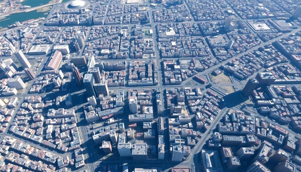
Aerial photography reveals the hidden geometry of cities. From above, you'll see how urban planners have shaped our landscapes into distinct patterns. These grid systems, invisible from the ground, become strikingly apparent when viewed from the sky.
You'll notice that many cities follow a strict grid layout, with streets intersecting at right angles. This design, popularized in the 19th century, aimed to create efficient, navigable urban spaces. New York's Manhattan and Barcelona's Eixample district exemplify this approach.
Other cities showcase radial patterns, with streets radiating outward from a central point. Paris and Washington D.C. are prime examples, their designs reflecting grand visions of urban harmony and power projection.
You'll also spot organic patterns in older cities that grew naturally over time. London and Rome exhibit winding streets and irregular blocks, telling stories of their long histories.
These aerial views offer valuable insights into a city's development, priorities, and cultural influences. They reveal how urban design shapes daily life, traffic flow, and social interactions.
Green Spaces and Urban Lungs
You'll discover fascinating patterns when analyzing aerial photographs of urban parks, revealing how cities integrate nature into their fabric.
Rooftop gardens, captured through aerial imagery, show their significant ecological impact on urban environments, providing habitats for wildlife and improving air quality.
These green spaces, visible in both ground-level and aerial photography, play an essential role in mitigating the urban heat island effect, offering cooler zones within densely built areas.
Aerial Park Pattern Analysis
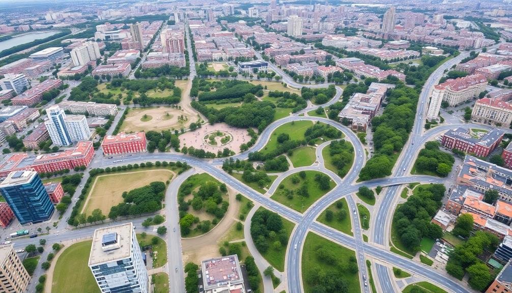
When viewed from above, a city's network of parks and green spaces reveals fascinating patterns that can inform urban design. Aerial photography allows you to see the distribution, size, and shape of these urban oases, offering valuable insights into a city's planning priorities and ecological health.
You'll notice that well-designed cities often feature a balanced distribution of green spaces, ensuring most residents have easy access to nature. Look for interconnected park systems that form green corridors, promoting biodiversity and providing routes for wildlife movement.
Pay attention to the shapes of parks – irregular, organic forms tend to offer more diverse habitats and interesting experiences for visitors.
Aerial views also highlight the contrast between densely built areas and green spaces, helping you assess if there's an adequate balance. You might spot patterns of small, scattered pocket parks in older neighborhoods, while newer developments may showcase larger, centralized green areas.
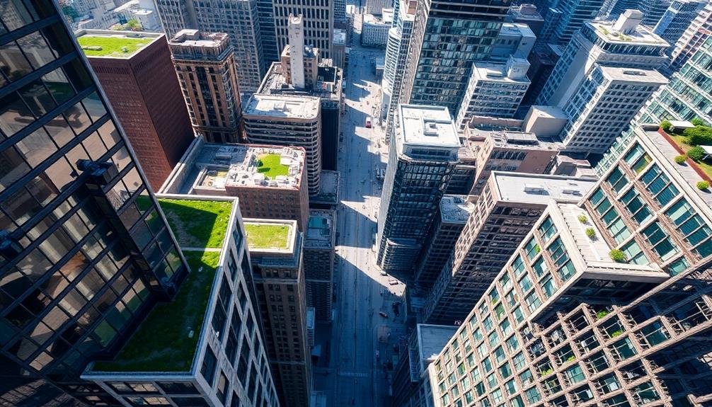
Rooftop Gardens' Ecological Impact
Rooftop gardens are increasingly transforming urban skylines into vibrant ecosystems, serving as essential "urban lungs" for cities. These green spaces offer numerous ecological benefits that you can observe through aerial photography.
They're not just visually appealing; they play a vital role in improving air quality, reducing urban heat island effects, and promoting biodiversity.
When you analyze aerial images of rooftop gardens, you'll notice their impact on the surrounding environment. They act as natural insulators, reducing energy consumption in buildings below.
You'll also see how they help manage stormwater runoff, alleviating pressure on urban drainage systems.
Aerial photography reveals the following ecological impacts of rooftop gardens:
- Creation of habitats for local wildlife, including birds and insects
- Reduction of carbon dioxide levels through plant photosynthesis
- Mitigation of air pollution by trapping particulate matter
- Enhancement of urban food security through small-scale agriculture
Urban Heat Island Mitigation
Urban heat islands, a phenomenon where cities experience considerably higher temperatures than surrounding rural areas, can be effectively mitigated through strategic green spaces.
Aerial photography reveals the stark contrast between heat-absorbing concrete jungles and cooling vegetation, highlighting the importance of urban lungs.
You'll notice that cities with well-planned green spaces enjoy lower temperatures and improved air quality. Parks, tree-lined streets, and rooftop gardens act as natural air conditioners, reducing the need for energy-intensive cooling systems.
These green areas absorb less heat than dark surfaces like asphalt and concrete, reflecting more sunlight and lowering ambient temperatures.
From above, you can identify potential locations for new green spaces. Look for large, unused rooftops, abandoned lots, or wide streets that could accommodate tree planting.
Transportation Networks and Flow
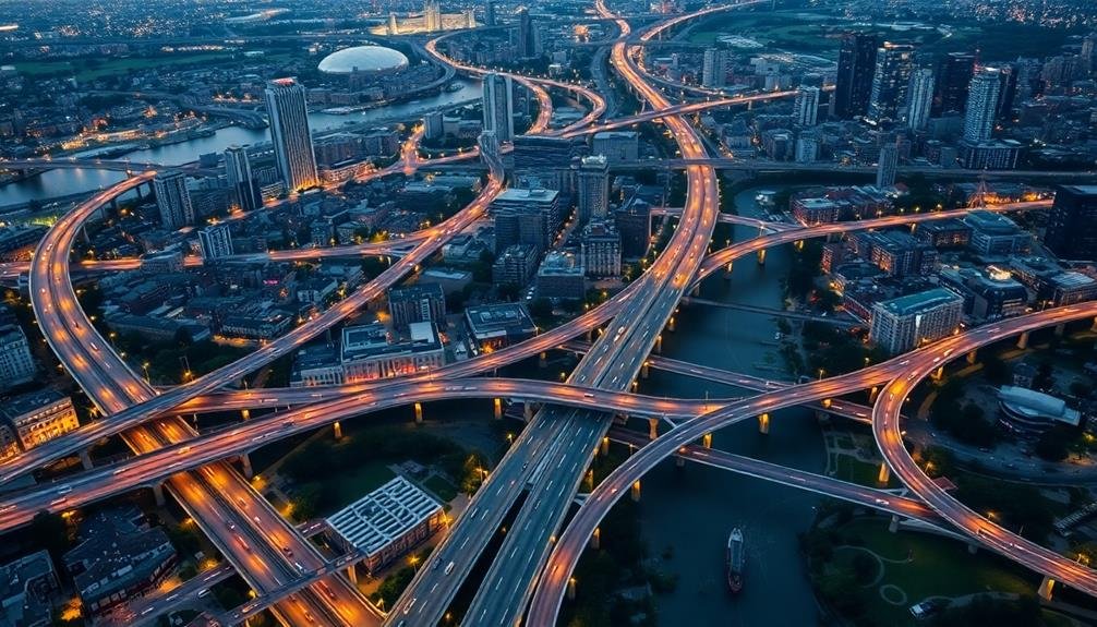
Photography can reveal the intricate patterns of urban traffic flow, helping you understand how vehicles move through city streets.
You'll notice the efficiency of well-designed mass transit systems captured in images of bustling subway stations and sleek light rail lines.
These visual insights into transportation networks can inform urban planning decisions and highlight areas for improvement in city mobility.
Traffic Pattern Visualization
Through the lens of aerial photography, traffic patterns in cities reveal themselves as intricate networks of motion and flow. You'll see bustling arteries pulsing with vehicles, intersections acting as essential nodes, and the ebb and flow of rush hour traffic.
These images offer invaluable insights into urban mobility, helping planners and designers optimize traffic management strategies.
By studying aerial photographs, you can identify:
- Congestion hotspots
- Underutilized routes
- Peak traffic periods
- Areas requiring infrastructure improvements
Analyzing these patterns allows you to understand how people move through the city. You'll notice how different neighborhoods connect, where bottlenecks occur, and how various modes of transportation interact.
This bird's-eye view helps in developing more efficient public transit routes, designing better road networks, and implementing smart traffic control systems.
Moreover, you can track changes in traffic patterns over time, revealing the impact of urban development and population growth.
This information is essential for future-proofing cities and ensuring sustainable mobility. By leveraging aerial photography for traffic pattern visualization, you're equipped to make data-driven decisions that enhance urban livability and connectivity.
Mass Transit Efficiency
When you examine aerial photographs of urban areas, you'll quickly notice the intricate web of mass transit systems threading through the cityscape.
These images reveal the efficiency of well-designed transportation networks, showing how subway lines, bus routes, and light rail systems interconnect to move thousands of people daily.
You'll observe how efficient mass transit systems often follow natural topography and existing infrastructure, minimizing disruption to the urban fabric.
Look for hubs where multiple lines converge, creating transfer points that maximize connectivity. These nodes are often surrounded by higher-density development, showcasing the symbiotic relationship between transit and urban growth.
Pay attention to the contrast between areas with robust public transportation and those without.
You'll notice less congestion and more pedestrian-friendly spaces in transit-rich neighborhoods.
The aerial view also highlights the importance of dedicated lanes for buses and trams, which cut through traffic like arteries pumping life into the city.
Density Variations Across Neighborhoods
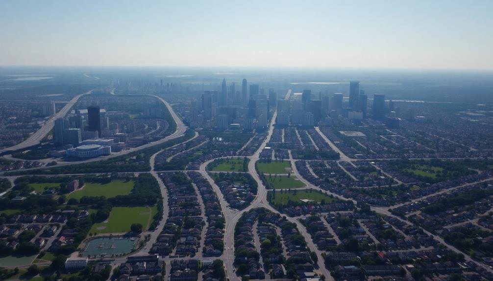
Neighborhoods in urban landscapes reveal a fascinating tapestry of density variations through the lens of a camera. As you examine aerial photographs, you'll notice stark contrasts between densely packed city centers and sprawling suburban areas.
These variations reflect the city's historical development, zoning regulations, and socioeconomic factors.
You can identify high-density areas by their compact building arrangements, narrow streets, and limited green spaces. In contrast, low-density neighborhoods feature more spacious layouts, wider roads, and abundant vegetation.
These differences impact various aspects of urban life, including:
- Transportation efficiency
- Energy consumption patterns
- Social interactions and community dynamics
- Distribution of amenities and services
Waterfront Development Strategies
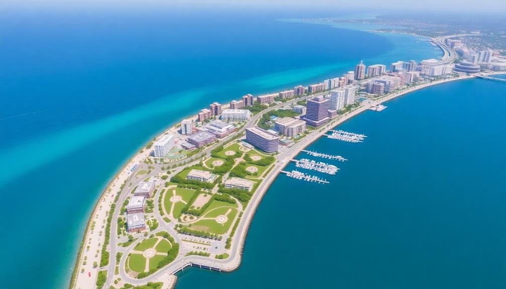
How do urban planners leverage waterfront areas to create vibrant, sustainable spaces? Aerial photography reveals key strategies for successful waterfront development. You'll notice patterns in how cities integrate water features, green spaces, and infrastructure to maximize their waterfronts' potential.
Effective waterfront strategies often include:
| Strategy | Purpose |
|---|---|
| Promenades | Encourage pedestrian activity |
| Mixed-use buildings | Promote 24/7 vibrancy |
| Green spaces | Enhance environmental quality |
| Public piers | Increase water access |
You'll observe how cities balance public access with private development. Some prioritize continuous waterfront paths, while others create pockets of activity. Look for the integration of flood mitigation measures, such as elevated structures or naturalized shorelines.
From above, you can assess the connectivity between waterfronts and city centers. Successful developments often feature clear sight lines and easy access from nearby neighborhoods. You might spot ferry terminals, water taxis, or bridges linking waterfront areas to the broader urban fabric.
Pay attention to the scale and orientation of buildings along the water. Well-designed waterfronts typically avoid creating walls of high-rises that block views and public access. Instead, you'll notice varied building heights and setbacks that preserve sight lines and create a more human-scaled environment.
Historical vs. Modern Urban Fabric
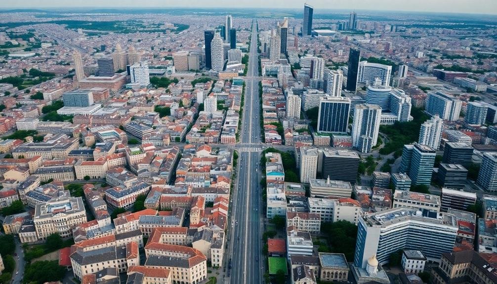
Aerial photography offers a unique perspective on the evolution of urban fabric, contrasting historical and modern development patterns. From above, you'll notice distinct differences in street layouts, building densities, and architectural styles.
Historical areas often feature narrow, winding streets and compact structures, while modern districts showcase wider roads and taller buildings.
You'll observe how cities have adapted over time, with newer developments often filling in gaps or expanding outwards. The juxtaposition of old and new becomes apparent, highlighting the challenges of integrating contemporary design with heritage preservation.
When examining aerial photos, pay attention to these key elements:
- Street patterns: Grid systems vs. organic layouts
- Green spaces: Distribution and size of parks and gardens
- Building footprints: Variations in size and shape
- Infrastructure: Changes in transportation networks
Suburban Sprawl Visualization
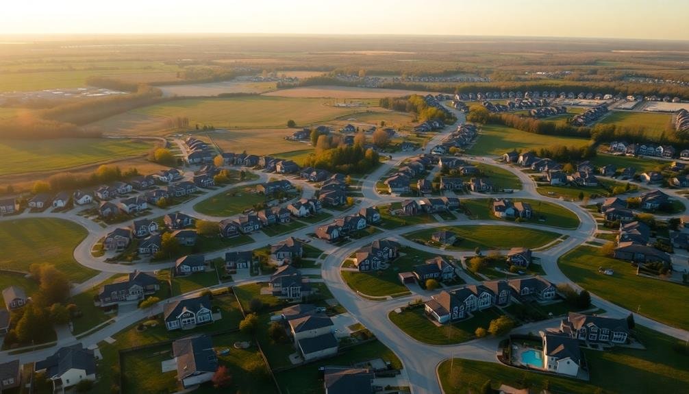
Shifting our focus from historical city centers to the outskirts, we encounter the phenomenon of suburban sprawl. Aerial photography reveals the stark contrast between dense urban cores and sprawling suburban developments. You'll notice repetitive patterns of single-family homes, winding streets, and cul-de-sacs that characterize these areas.
From above, you can easily identify the inefficient use of land and resources in suburban sprawl. The images highlight how this development pattern leads to car dependency, reduced walkability, and increased infrastructure costs. You'll observe vast parking lots, wide roads, and a lack of mixed-use spaces.
To better understand the visual cues of suburban sprawl, consider these key elements:
| Feature | Urban Core | Suburban Sprawl |
|---|---|---|
| Street layout | Grid-like | Curvilinear |
| Building density | High | Low |
| Green spaces | Compact parks | Large lawns |
| Transportation | Multi-modal | Car-centric |
| Land use | Mixed | Segregated |
Industrial Zones and Urban Planning
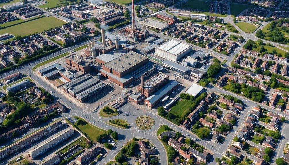
Steel mills and warehouses dominate the landscape of industrial zones, offering a stark contrast to residential and commercial areas. From above, you'll notice the distinct layout and organization of these zones, which are often strategically placed away from city centers.
You'll see large, rectangular structures, expansive parking lots, and intricate networks of roads designed for heavy vehicles.
Aerial photography reveals the impact of industrial zones on urban planning:
- Buffer zones between industrial and residential areas
- Transportation corridors connecting industrial zones to highways and ports
- Green spaces integrated to mitigate environmental effects
- Zoning regulations influencing the size and placement of facilities
You'll observe how cities evolve around these industrial hubs, with supporting businesses and infrastructure developing nearby.
The photos highlight the challenges urban planners face in balancing economic needs with quality of life concerns.
You'll notice efforts to modernize older industrial areas, incorporating sustainable practices and adaptive reuse of abandoned facilities.
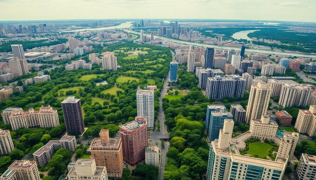
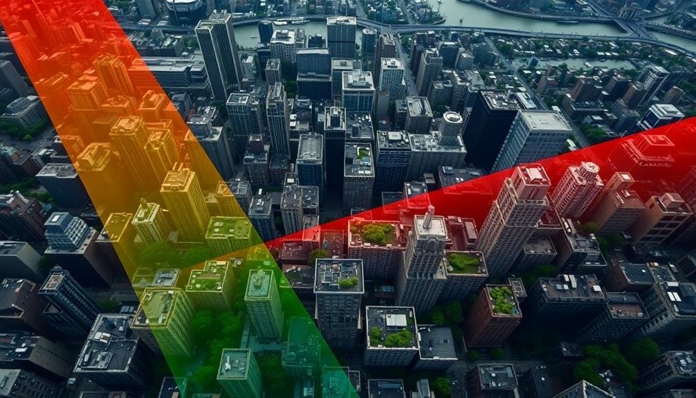
Vertical Growth in City Centers
Skyscrapers reach up from the heart of city centers, creating a vertical landscape that defines urban skylines. You'll notice how these towering structures maximize limited ground space, accommodating more people and businesses in a compact area. This vertical growth strategy allows cities to expand upward, preserving valuable land and reducing urban sprawl.
As you examine aerial photographs, you'll see how skyscrapers cluster together, forming distinct districts within the city. These high-rise zones often house financial centers, corporate headquarters, and luxury residences. You'll also spot the challenges of vertical growth, such as increased traffic congestion and the need for efficient public transportation systems.
| Vertical Growth Pros | Vertical Growth Cons |
|---|---|
| Efficient land use | Shadow effects |
| Increased density | Wind tunnel effects |
| Iconic skylines | Infrastructure strain |
| Economic hubs | Potential fire risks |
Urban Heat Island Effects
You'll notice urban heat islands through photography's ability to capture temperature hotspots in cities.
These images reveal stark contrasts between heat-absorbing concrete jungles and cooler, greener areas.
Temperature Hotspots Revealed
Although often overlooked, thermal imaging photography has become a powerful tool in revealing urban heat island effects.
You'll find that these high-tech images can pinpoint temperature hotspots within cities, helping urban planners and designers make informed decisions about city layouts and green spaces.
When you examine thermal images of urban areas, you'll notice stark contrasts between cooler, vegetated areas and hotter, concrete-dominated zones.
These photos highlight the need for strategic urban planning to mitigate heat island effects.
You'll see how:
- Dark surfaces like asphalt absorb more heat
- Tall buildings create heat-trapping canyons
- Green spaces act as natural cooling zones
- Water bodies provide temperature regulation
Greenery's Cooling Impact
While urban heat islands pose notable challenges, photography offers compelling evidence of greenery's cooling impact. Aerial images reveal stark temperature differences between green spaces and concrete jungles. You'll notice that parks, tree-lined streets, and urban forests act as natural air conditioners, mitigating the heat island effect.
These green oases can lower ambient temperatures by up to 5°C, providing much-needed relief during scorching summers. They absorb heat, increase shade, and release moisture through evapotranspiration. By strategically incorporating greenery into urban planning, you can notably improve city livability and reduce energy consumption.
Here's a comparison of different green elements and their cooling effects:
| Green Element | Temperature Reduction | Additional Benefits |
|---|---|---|
| Urban Parks | 2-3°C | Recreation, biodiversity |
| Green Roofs | 1-2°C | Insulation, stormwater management |
| Street Trees | 1-1.5°C | Air purification, aesthetics |
| Vertical Gardens | 0.5-1°C | Sound insulation, improved air quality |
Frequently Asked Questions
How Do Aerial Photographers Capture These Urban Design Images?
You'll find aerial photographers use drones, helicopters, or planes to capture urban design images. They'll employ high-resolution cameras, plan flight paths, and time shots carefully. They'll also consider lighting, weather conditions, and composition for stunning results.
What Equipment Is Needed for High-Quality Sky-High Urban Photography?
You'll need a high-resolution camera, wide-angle lens, and drone for aerial shots. Don't forget a sturdy tripod, remote shutter release, and ND filters. For processing, invest in photo editing software and a powerful computer.
Are There Legal Restrictions on Aerial Photography in Urban Areas?
You'll face legal restrictions on aerial photography in urban areas. Check local laws, as they vary by location. You're often required to obtain permits, respect privacy and no-fly zones, and follow drone regulations if applicable.
How Can City Planners Use Aerial Imagery to Improve Urban Design?
You can use aerial imagery to analyze land use patterns, identify green spaces, assess traffic flow, and plan infrastructure. It'll help you spot urban sprawl, evaluate building density, and visualize potential developments for more efficient city planning.
What Are the Challenges of Interpreting Urban Patterns From Aerial Photographs?
You'll face challenges like distorted perspectives, shadows obscuring details, and outdated imagery. It's tough to gauge scale, identify specific structures, and understand street-level dynamics. You can't always see cultural nuances or socioeconomic factors from above.
In Summary
You've seen how aerial photography reveals the secrets of our cities. It's given you a new perspective on urban design, from grid patterns to green spaces. You've witnessed the flow of transportation and the variations in density. You've observed waterfront development, sprawl, and industrial zones. You've marveled at vertical growth and recognized urban heat islands. Now, you're equipped with valuable insights to shape and improve our urban environments for the future.
As educators and advocates for responsible drone use, we’re committed to sharing our knowledge and expertise with aspiring aerial photographers.


Leave a Reply