
Skyborne images disclose the dramatic transformations cities undergo during revitalization. You'll see expansions of urban green spaces, with new parks and tree-lined streets enhancing city aesthetics. Infrastructure upgrades become apparent, showcasing improved transportation networks and modernized utilities. Gentrification patterns emerge, revealing how neighborhoods evolve over time. Former industrial areas transform into vibrant mixed-use spaces, while waterfronts metamorphose from neglected zones to bustling public areas. Traffic flow changes and transportation improvements are clearly visible from above. The city's skyline shifts, reflecting economic growth and architectural diversity. These aerial perspectives offer invaluable insights into the complex tapestry of urban renewal and its far-reaching impacts.
Urban Green Space Expansion
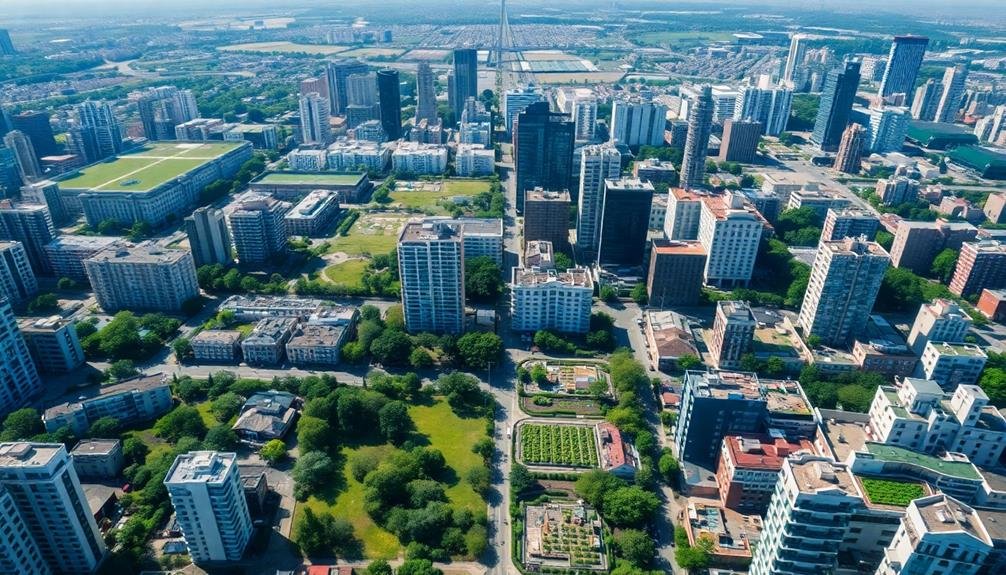
The expansion of urban green spaces is a crucial component of city revitalization efforts. When you look at aerial images of cities undergoing renewal, you'll notice an increase in parks, community gardens, and tree-lined streets.
These green spaces serve multiple purposes, improving air quality, reducing urban heat islands, and providing recreational areas for residents.
You'll see that cities are repurposing unused lots and brownfields into vibrant green areas. Rooftop gardens and vertical forests are becoming more common, adding greenery to dense urban environments.
These initiatives not only beautify the cityscape but also contribute to biodiversity and wildlife habitats within urban settings.
From above, you can observe how green corridors connect different parts of the city, creating networks for both people and nature.
These corridors often incorporate bike lanes and pedestrian paths, encouraging sustainable transportation.
You'll also notice how green spaces are strategically placed near residential areas, ensuring equitable access for all citizens.
Infrastructure Upgrades From Above
When you look down on a city undergoing revitalization, you'll spot a patchwork of infrastructure upgrades transforming the urban landscape.
From above, you can see the interconnected web of improvements that mightn't be as noticeable from street level. These aerial views reveal the scope and progress of large-scale projects, giving you a unique perspective on the city's evolution.
As you scan the cityscape, you'll notice:
- New transportation networks: Freshly paved roads, expanded bike lanes, and light rail systems snaking through the urban grid
- Modernized utility systems: Updated power grids with solar panel arrays and improved water management facilities
- Revamped public spaces: Renovated parks, sports complexes, and community centers dotting the landscape
- Sustainable developments: Green roofs, urban farms, and eco-friendly building designs emerging among older structures
These bird's-eye observations offer valuable insights into the city's revitalization efforts.
You'll see how different projects connect and complement each other, creating a more efficient and livable urban environment.
Gentrification Patterns in Neighborhoods
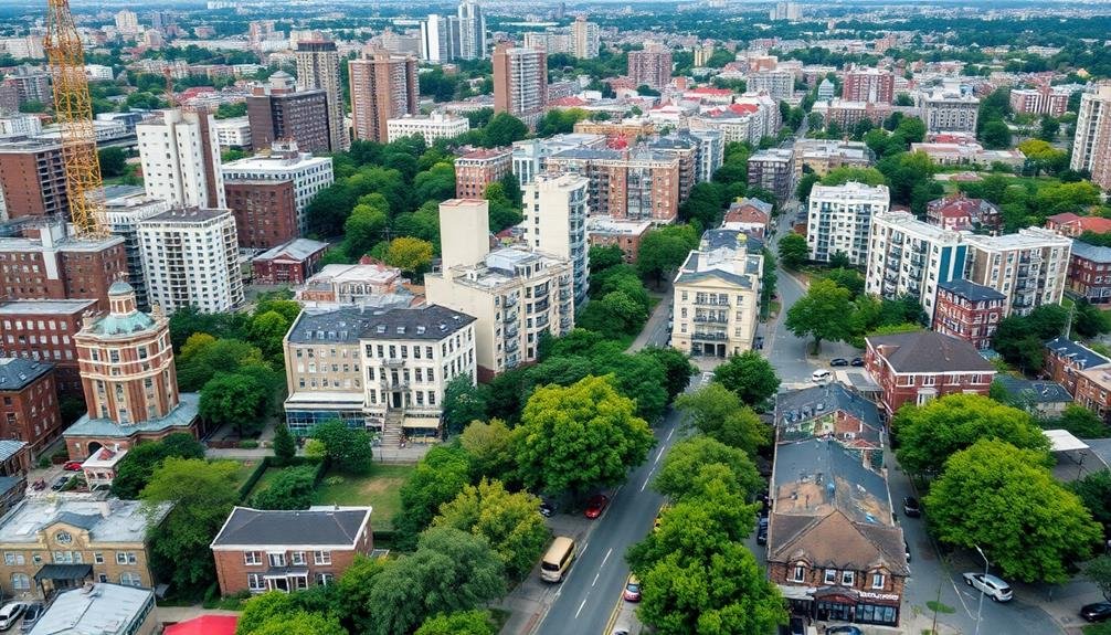
Three distinct patterns emerge when examining gentrification across neighborhoods undergoing revitalization.
First, you'll notice a ripple effect radiating outward from the city center. As downtown areas improve, adjacent neighborhoods begin to change, with property values rising and demographics shifting. This pattern often creates concentric circles of gentrification, each ring representing a different stage of the process.
Second, you'll observe corridor-based gentrification along major transportation routes. As cities invest in public transit or improve existing thoroughfares, you'll see pockets of renewal sprouting up along these arteries. This linear pattern can create a stark contrast between revitalized areas and those just a block or two away.
Finally, you'll identify sporadic gentrification, where isolated pockets of renewal appear seemingly at random throughout the city. These hotspots often emerge around specific amenities or developments, such as parks, universities, or new commercial centers.
This pattern can create a patchwork effect, with gentrified areas interspersed among unchanged neighborhoods.
Redevelopment of Industrial Areas
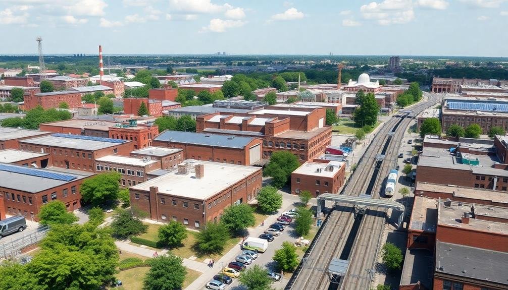
Transforming once-thriving industrial zones, cities are breathing new life into abandoned factories and warehouses.
You'll notice these redevelopment projects are reshaping urban landscapes, creating vibrant mixed-use spaces that blend residential, commercial, and recreational elements. From above, you can observe the stark contrast between old industrial sites and their modern counterparts.
As you examine aerial imagery, you'll spot key indicators of industrial area redevelopment:
- Green spaces: Former concrete jungles now feature parks, community gardens, and tree-lined walkways.
- Adaptive reuse: Old factories converted into loft apartments, offices, or cultural centers, preserving architectural heritage.
- Infrastructure upgrades: New roads, bike lanes, and public transit connections improving accessibility.
- Waterfront revitalization: Once-polluted riverfronts and harbors transformed into recreational areas and promenades.
You'll also notice how these projects often act as catalysts for surrounding neighborhoods, spurring further development and investment.
By studying before-and-after images, you can track the progress of these transformations over time, gaining insights into the city's evolving urban fabric and economic priorities.
This birds-eye view offers a unique perspective on the reimagining of industrial landscapes and their impact on overall city revitalization efforts.
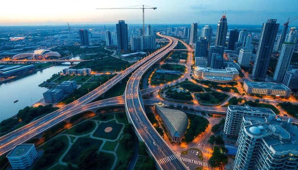
Traffic Flow and Transportation
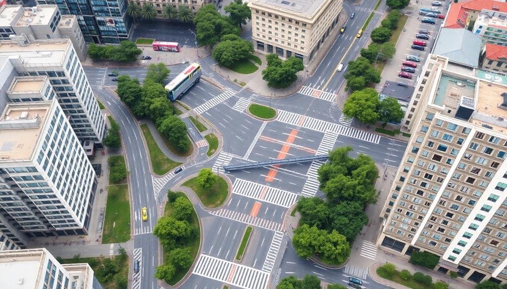
In light of city revitalization efforts, traffic flow and transportation play an essential role in shaping urban mobility. Aerial imagery can reveal significant insights into traffic patterns, congestion hotspots, and infrastructure effectiveness.
You'll notice how these images highlight the need for improved road networks, public transit systems, and alternative transportation options.
By analyzing skyborne data, you can identify areas where traffic bottlenecks occur and propose solutions like road widening, traffic light synchronization, or the addition of dedicated bus lanes.
You'll also spot opportunities for implementing bike lanes, pedestrian walkways, and green corridors to promote sustainable transportation.
Aerial views can help you assess the efficiency of existing public transit routes and suggest potential new lines or transportation hubs.
You'll be able to evaluate parking availability and propose strategically located park-and-ride facilities to reduce inner-city congestion.
Moreover, these images allow you to track the progress of ongoing transportation projects and their impact on surrounding areas.
Skyline Changes Over Time
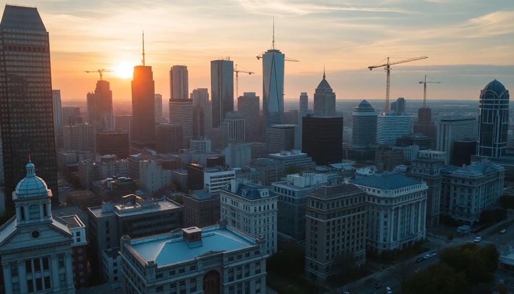
Over the course of decades, a city's skyline serves as a visual chronicle of its growth and evolution. You'll notice that as cities revitalize, their skylines undergo significant transformations. These changes reflect economic prosperity, architectural trends, and urban planning priorities.
When you examine historical photographs alongside current images, you'll observe the following skyline changes:
- Height increases: New skyscrapers and high-rises pierce the sky, often dwarfing older structures.
- Density shifts: Gaps between buildings fill in as vacant lots give way to new developments.
- Architectural diversity: Modern designs introduce varied shapes, materials, and styles, creating a more eclectic skyline.
- Green spaces: Rooftop gardens and parks emerge, adding splashes of nature to the urban landscape.
You'll find that these changes aren't just aesthetic; they're functional too. Taller buildings maximize limited urban space, while mixed-use developments promote efficient land use.
As you track a city's skyline evolution, you're witnessing its economic growth, technological advancements, and shifting cultural values. The skyline becomes a reflection of the city's past, present, and future aspirations, offering valuable insights into its revitalization journey.
Waterfront Revitalization Projects
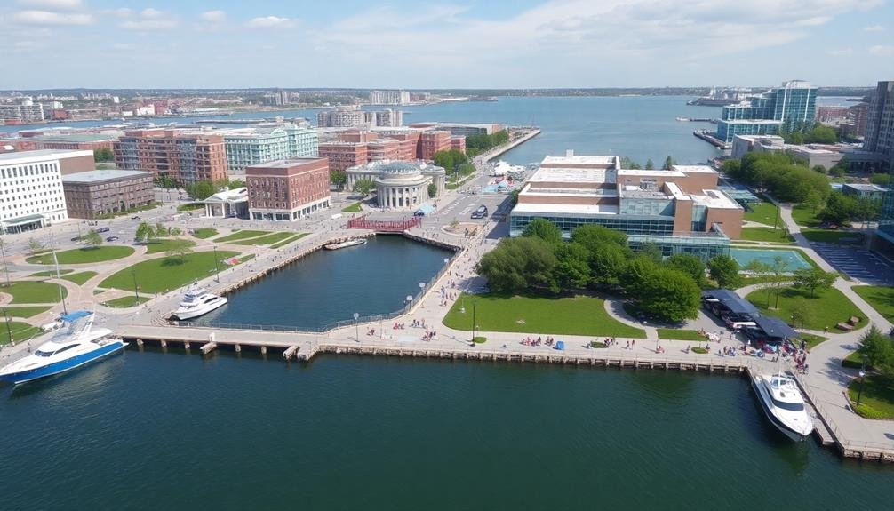
You'll find that waterfront revitalization projects have become a cornerstone of urban renewal efforts worldwide.
These initiatives often transform once-neglected industrial harbors into vibrant public spaces, featuring pedestrian-friendly coastal promenades that invite locals and tourists alike.
Mixed-use waterfront developments blend residential, commercial, and recreational areas, creating dynamic new neighborhoods that reconnect cities with their aquatic environments.
Transformed Industrial Harbors
Transformed industrial harbors stand as shining examples of urban renewal and waterfront revitalization. As you gaze down from above, you'll notice how these once-neglected areas have been reimagined and repurposed. Former shipping yards and warehouses now bustle with new life, offering a mix of residential, commercial, and recreational spaces.
From your aerial vantage point, you can spot key features that define these revitalized harbors:
- Pedestrian-friendly promenades lining the water's edge
- Mixed-use developments blending apartments, offices, and retail spaces
- Green spaces and parks integrated into the urban fabric
- Preserved historic structures repurposed for modern use
You'll also observe how these transformed harbors connect seamlessly with the surrounding city. New transit links, bike paths, and walkways make these areas easily accessible to residents and visitors alike.
The aerial view reveals the careful balance struck between honoring the industrial heritage and embracing contemporary design. As you scan the skyline, you'll see how these revitalized harbors have become focal points for urban regeneration, breathing new life into once-forgotten waterfronts and creating vibrant, sustainable communities.
Pedestrian-Friendly Coastal Promenades
Pedestrian-friendly coastal promenades have become the heartbeat of waterfront revitalization projects. From aerial views, you'll notice these vibrant strips hugging shorelines, transforming once-neglected areas into bustling public spaces.
These promenades often feature wide, well-lit walkways lined with trees, benches, and public art installations.
You'll spot carefully designed gathering spaces, such as amphitheaters and plazas, that host community events and foster social interactions. Bike lanes and jogging paths are common sights, encouraging active lifestyles and sustainable transportation. Restaurants, cafes, and small shops dot the promenade, creating a lively atmosphere and boosting local economies.
From above, you'll observe how these promenades seamlessly connect to nearby neighborhoods and transit hubs, making them easily accessible to residents and visitors alike.
You'll also notice clever landscaping techniques that incorporate native plants and green spaces, enhancing biodiversity and creating natural buffers against coastal erosion.
These aerial images reveal how pedestrian-friendly coastal promenades have become catalysts for urban renewal, breathing new life into waterfronts and creating inviting spaces that celebrate the unique character of each city's coastline.
Mixed-Use Waterfront Developments
Over the past decade, mixed-use waterfront developments have emerged as a cornerstone of urban revitalization efforts. These projects combine residential, commercial, and recreational spaces along waterfronts, transforming once-neglected areas into vibrant community hubs.
From aerial perspectives, you'll notice how these developments integrate seamlessly with the existing urban fabric, creating a harmonious blend of old and new.
As you examine these waterfront projects from above, you'll observe:
- Diverse architectural styles that respect the area's heritage while introducing modern elements
- Green spaces and parks interspersed among buildings, providing essential recreational areas
- Marinas and boat docks that cater to water-based activities and transportation
- Public spaces like plazas and amphitheaters that foster community gatherings and events
These mixed-use developments not only revitalize the waterfront but also boost the local economy by attracting businesses, residents, and tourists.
You'll see increased foot traffic and activity in these areas, signaling successful urban regeneration. By studying aerial imagery of these projects, you can gain valuable insights into effective waterfront revitalization strategies and their impact on city dynamics.
Frequently Asked Questions
How Do Aerial Images Capture Nighttime Urban Activity Patterns?
You'll see nighttime aerial images capturing urban activity through illuminated areas. They'll show you bright spots indicating bustling nightlife, commercial zones, and traffic patterns. You can observe how light clusters reveal where people congregate after dark.
What Legal Restrictions Exist for Using Drone Imagery in Urban Planning?
You'll face restrictions on drone imagery in urban planning. You can't fly over people, must stay below 400 feet, and need permits for commercial use. Privacy concerns also limit capturing images of private property.
Can Skyborne Images Detect Changes in Air Quality Over Time?
Yes, you can use skyborne images to detect changes in air quality over time. They'll capture visible pollutants, haze, and smog patterns. You'll need specialized sensors and imaging techniques to measure specific air quality indicators accurately.
How Accurate Are Population Estimates Derived From Aerial Imagery?
You'll find that population estimates from aerial imagery can be quite accurate, especially in urban areas. They're not perfect, though. You'll typically see accuracy rates of 80-95%, depending on image quality and analysis techniques used.
What Role Do Satellite Images Play in Tracking Urban Heat Islands?
You'll find satellite images essential for tracking urban heat islands. They reveal temperature differences between cities and surrounding areas. You can use this data to identify hot spots, plan green spaces, and implement cooling strategies for urban areas.
In Summary
You've seen how skyborne images offer a unique perspective on city revitalization. They reveal the greening of urban spaces, infrastructure improvements, and changing neighborhood dynamics. You can track gentrification patterns, industrial area transformations, and evolving traffic flows. These aerial views also showcase dramatic skyline changes and waterfront rejuvenation projects. By examining cities from above, you'll gain valuable insights into urban development trends and the effectiveness of revitalization efforts over time.
As educators and advocates for responsible drone use, we’re committed to sharing our knowledge and expertise with aspiring aerial photographers.


Leave a Reply