
Farm monitoring from above boosts crop yield by giving you a thorough view of your fields. With drones and satellite imagery, you'll spot issues like pests, diseases, and nutrient deficiencies early on. You can optimize irrigation, applying water precisely where it's needed. Precision fertilizer application guarantees your crops get the right nutrients at the right time. You'll save time and money by targeting resources efficiently, reducing waste and environmental impact. Accurate yield predictions help you plan better, from resource allocation to marketing. By embracing this aerial perspective, you're not just improving yields – you're revolutionizing your entire farming approach. There's much more to uncover about this game-changing technology.
Key Takeaways
- Aerial monitoring enables early detection of pests and diseases, allowing for timely interventions that protect crop yield.
- Precise identification of nutrient deficiencies and water stress guides targeted treatments, optimizing plant health and productivity.
- Accurate yield predictions inform resource allocation and harvesting decisions, maximizing overall farm output.
- Time and cost savings from efficient monitoring allow farmers to focus on critical tasks that directly impact yield.
- Environmental impact reduction through precise resource application leads to healthier soil and more sustainable, higher-yielding crops.
Precision Agriculture Revolution

Over the past decade, precision agriculture has revolutionized the farming industry. You'll find that this technology-driven approach allows you to manage your fields with unprecedented accuracy. By using data from satellites, drones, and sensors, you can now make informed decisions about every aspect of crop production.
You're no longer relying on guesswork. Instead, you're using real-time information to optimize irrigation, fertilization, and pest control. This targeted approach means you're using resources more efficiently, reducing waste, and minimizing environmental impact.
With precision agriculture, you're able to identify variations in soil conditions, crop health, and yield potential across your fields. This enables you to tailor your management practices to specific areas, maximizing productivity in high-performing zones and addressing issues in underperforming ones.
You'll also benefit from predictive analytics, which help you anticipate weather patterns, disease outbreaks, and market trends. This foresight allows you to make proactive decisions, potentially saving your crops from disasters and capitalizing on market opportunities.
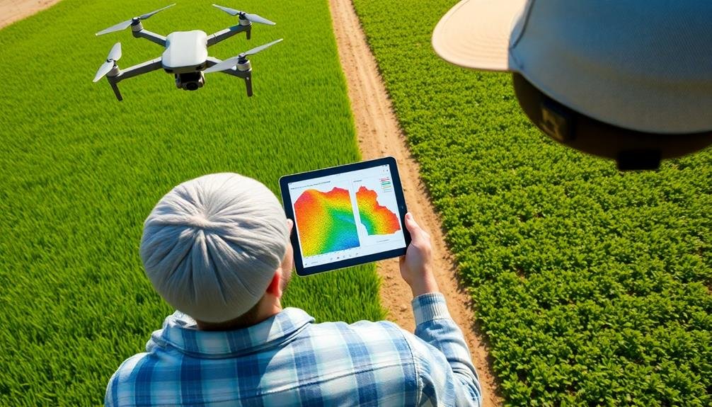
Drone Technology in Farming

You'll find drones revolutionizing precision agriculture with their advanced capabilities.
These aerial devices can efficiently survey large areas, providing farmers with detailed crop health assessments.
Precision Agriculture Applications
Precision agriculture has soared to new heights with the advent of drone technology in farming. You can now leverage drones to optimize your crop management strategies with unprecedented accuracy. These aerial tools allow you to collect real-time data on crop health, soil conditions, and irrigation needs across your entire field.
With drone-captured imagery, you'll identify problem areas quickly, such as pest infestations or nutrient deficiencies. This enables you to apply targeted treatments, reducing waste and environmental impact. You can also use drones to create detailed 3D maps of your terrain, helping you plan efficient planting patterns and drainage systems.
During the growing season, you'll monitor crop progress more effectively. Drones equipped with multispectral sensors can detect subtle changes in plant health before they're visible to the naked eye. This early warning system lets you intervene promptly, potentially saving entire sections of your crop.
At harvest time, you'll use drone data to predict yields accurately and plan your harvest schedule. By integrating drone technology into your precision agriculture practices, you'll boost crop yields, reduce costs, and make more informed decisions throughout the growing cycle.
Crop Health Assessment
Farmers now have a powerful ally in the sky for evaluating crop health. Drone technology allows you to assess your fields quickly and accurately, identifying potential issues before they become serious problems. With high-resolution cameras and multispectral sensors, drones can detect subtle changes in plant color, growth patterns, and overall vigor that might be invisible to the naked eye.
You'll benefit from drone-based crop health assessment in several ways:
- Early detection of pests and diseases
- Precise identification of nutrient deficiencies
- Timely intervention for water stress management
By analyzing drone-captured imagery, you can create detailed maps of your fields, highlighting areas that require immediate attention. This targeted approach enables you to optimize resource allocation, applying treatments only where needed.
You'll reduce waste, save time, and minimize environmental impact while maximizing crop yield.
Drones also allow you to monitor crop development throughout the growing season, helping you make informed decisions about harvest timing and yield predictions.
With this technology, you're no longer limited by ground-based observations or sporadic satellite imagery. Instead, you'll have a thorough, up-to-date view of your crops' health, empowering you to take proactive measures and improve overall farm productivity.
Aerial Crop Health Assessment

You'll find aerial crop health assessment invaluable for early stress detection in your fields.
It enables you to apply fertilizer with precision, targeting specific areas that need attention.
Additionally, you can optimize your irrigation management by identifying dry spots and adjusting water distribution accordingly.
Early Stress Detection
Regularly, aerial crop health assessments revolutionize early stress detection in modern farming.
You'll be able to spot issues before they become visible to the naked eye, allowing for timely interventions. By using advanced imaging technologies, you can identify plant stress caused by various factors, including pests, diseases, nutrient deficiencies, and water stress.
These early detection capabilities offer significant advantages:
- Rapid response: You'll have the opportunity to address problems quickly, minimizing crop damage and potential yield losses.
- Targeted treatments: With precise information about stressed areas, you can apply interventions only where needed, reducing costs and environmental impact.
- Improved resource allocation: Early stress detection helps you optimize the use of water, fertilizers, and pesticides, leading to more sustainable farming practices.
Precision Fertilizer Application
Precision fertilizer application takes aerial crop health assessment to the next level. By using drones or satellites to map your fields, you'll gain detailed insights into nutrient variations across your crops.
This data allows you to create precise fertilizer prescriptions tailored to specific areas of your field. You'll no longer need to apply fertilizer uniformly, which often leads to over-application in some areas and under-application in others.
Instead, you can target areas that need more nutrients while avoiding waste in areas that don't. This approach not only optimizes your crop yield but also reduces your environmental impact and saves you money on fertilizer costs.
With precision fertilizer application, you'll be able to:
- Identify nutrient deficiencies in real-time
- Create variable-rate application maps
- Adjust fertilizer rates based on crop needs
- Reduce nutrient runoff and groundwater contamination
- Improve overall crop quality and yield
Irrigation Management Optimization
Aerial crop health assessment isn't just for fertilizer management—it's also a game-changer for irrigation. By using drones or satellites to monitor your fields, you'll gain invaluable insights into your crops' water needs. These advanced imaging techniques can detect moisture stress before it's visible to the naked eye, allowing you to enhance your irrigation strategy.
With aerial monitoring, you can:
- Identify areas of water stress or overwatering
- Create precise irrigation maps for variable-rate systems
- Track the effectiveness of your current irrigation practices
By analyzing multispectral images, you'll be able to see variations in crop health across your fields. This information helps you pinpoint areas that need more or less water, guaranteeing that each part of your field receives the ideal amount.
You'll also be able to detect irrigation system malfunctions, such as leaks or blockages, more quickly.
Implementing irrigation management enhancement based on aerial data can lead to significant water savings and improved crop yields.
You'll reduce water waste, lower your costs, and guarantee your crops receive the right amount of water at the right time, maximizing their growth potential and overall health.
Optimizing Irrigation Practices

Smart irrigation practices can dramatically improve crop yield and water efficiency. By using farm monitoring from above, you'll gain valuable insights into your field's water needs. Aerial imagery and sensors can detect moisture levels across your entire farm, allowing you to identify areas that require more or less water.
You can use this data to implement precision irrigation techniques. Instead of watering your entire field uniformly, you'll be able to adjust water distribution based on specific crop needs and soil conditions. This targeted approach reduces water waste and guarantees each plant receives ideal hydration.
Additionally, you can schedule irrigation based on real-time weather forecasts and soil moisture data. This prevents overwatering during rainy periods and guarantees timely irrigation during dry spells.
You'll also be able to detect irrigation system malfunctions quickly, such as leaks or blockages, minimizing water loss and crop damage.
Early Pest and Disease Detection

Countless crops are lost each year due to undetected pests and diseases. You can greatly reduce these losses by implementing early detection methods through farm monitoring from above. Aerial imaging and remote sensing technologies allow you to spot potential issues before they become widespread, giving you an essential advantage in protecting your crops.
By utilizing drones or satellite imagery, you'll be able to identify subtle changes in plant health that may indicate the presence of pests or diseases. These advanced monitoring techniques can detect:
- Changes in leaf color or texture
- Irregular growth patterns
- Areas of stunted or wilting plants
Early detection enables you to take swift action, applying targeted treatments only where needed. This precision approach not only saves time and resources but also minimizes the environmental impact of pesticides and fungicides. You'll be able to contain outbreaks more effectively, preventing them from spreading to larger areas of your farm.
Moreover, by consistently monitoring your fields, you'll build a thorough database of pest and disease patterns over time. This valuable information will help you predict future outbreaks and develop more effective prevention strategies, ultimately leading to higher crop yields and increased profitability.
Accurate Yield Predictions
Predicting crop yields accurately can revolutionize your farm management strategies. By leveraging aerial monitoring technology, you'll gain valuable insights into your fields' potential productivity well before harvest time.
These predictions allow you to make informed decisions about resource allocation, marketing, and storage needs. Aerial imagery captures data on plant health, density, and growth stages across your entire farm.
Advanced algorithms then analyze this information, combining it with historical yield data, weather patterns, and soil conditions to generate precise yield forecasts. You'll be able to identify high-performing areas and those that may need additional attention.
With accurate yield predictions, you can optimize your harvest timing and equipment deployment. You'll also have a better understanding of your expected income, enabling more effective financial planning and risk management.
Additionally, these predictions help you negotiate contracts with buyers and secure favorable prices for your crops.
Efficient Resource Allocation

Building on accurate yield predictions, efficient resource allocation allows you to maximize your farm's productivity and profitability.
You'll be able to distribute water, fertilizers, and other resources precisely where they're needed most. By utilizing farm monitoring data, you can identify areas that require more attention and those that are performing well.
This targeted approach helps you:
- Reduce waste by applying resources only where necessary
- Minimize environmental impact through precise chemical applications
- Optimize labor and equipment usage across your fields
You'll find that efficient resource allocation leads to significant cost savings and improved crop health.
By focusing your efforts on underperforming areas, you can address issues quickly and effectively. Meanwhile, you won't waste resources on parts of your farm that are already thriving.
Farm monitoring technologies provide you with real-time data on soil moisture, nutrient levels, and plant health.
This information enables you to make informed decisions about irrigation schedules, fertilizer applications, and pest control measures.
As a result, you'll see improved crop yields, reduced input costs, and a more sustainable farming operation overall.
Time and Cost Savings

Implementing farm monitoring systems can lead to substantial time and cost savings for your agricultural operation.
You'll reduce the need for manual field inspections, allowing you to allocate your workforce more efficiently. Drones and satellite imagery provide quick, thorough overviews of your entire farm, eliminating the time-consuming task of walking or driving through fields.
You'll also save money on inputs by applying fertilizers, pesticides, and water only where needed. Precision agriculture techniques, guided by monitoring data, help you avoid over-application and waste.
Additionally, early detection of crop stress or disease outbreaks enables you to address issues before they become costly problems.
Farm monitoring systems can optimize your harvesting schedule, ensuring you pick crops at peak ripeness. This maximizes yield and quality while minimizing losses due to overripe produce.
You'll also reduce fuel costs associated with unnecessary field visits and equipment use.
Environmental Impact Reduction

Beyond cost and time benefits, farm monitoring systems play a crucial role in reducing environmental impact. By providing precise data on crop health, soil conditions, and water needs, these systems allow you to make informed decisions that minimize resource waste and environmental damage.
You'll be able to:
- Optimize fertilizer use, reducing runoff and groundwater contamination
- Improve water management, preventing overwatering and conserving this precious resource
- Decrease pesticide application through early detection of pest infestations
With farm monitoring, you're equipped to practice precision agriculture, targeting only the areas that need attention. This approach markedly reduces the overall chemical input in your fields.
You'll also be able to identify and address potential issues before they escalate, preventing the need for more aggressive interventions later.
Moreover, by maximizing crop yield in existing farmland, you're reducing the pressure to convert natural habitats into agricultural land. This helps preserve biodiversity and maintain ecological balance.
Farm monitoring systems empower you to be a steward of the environment while improving your agricultural productivity, creating a win-win situation for both your business and the planet.
Frequently Asked Questions
How Do Farmers Ensure Data Privacy When Using Aerial Monitoring Technologies?
To guarantee data privacy with aerial monitoring, you should work with reputable service providers, use secure data storage systems, and implement strict access controls. You'll also want to review and understand the privacy policies of any technology you're using.
What Certifications or Licenses Are Required to Operate Drones for Agricultural Purposes?
You'll need a Remote Pilot Certificate from the FAA to operate drones commercially for agriculture. You must pass an aeronautical knowledge test and be at least 16 years old. Some states may require additional licenses or permits.
Can Aerial Monitoring Be Effective for Small-Scale or Organic Farms?
Yes, aerial monitoring can be effective for small-scale and organic farms. You'll find it helps with crop health assessment, pest detection, and resource management. It's a valuable tool regardless of farm size or farming practices.
How Does Weather Affect the Accuracy of Aerial Farm Monitoring?
Weather can considerably impact your aerial farm monitoring accuracy. You'll find that cloud cover, heavy rain, or strong winds can interfere with image quality and data collection. It's best to plan your monitoring flights on clear, calm days.
Are There Any Potential Negative Impacts on Wildlife From Drone Usage?
You'll find that drones can disturb wildlife, causing stress and altering behavior patterns. They might disrupt nesting sites, scare animals, or interfere with migration. However, responsible drone use can minimize these impacts through proper planning and timing.
In Summary
You've seen how farm monitoring from above revolutionizes agriculture. By embracing drone technology and aerial assessments, you'll boost crop yields, optimize resources, and reduce environmental impact. You're now equipped to detect issues early, predict yields accurately, and make informed decisions. Don't hesitate to implement these precision farming techniques. They'll save you time and money while increasing productivity. The future of farming is here, and it's looking down from above.
As educators and advocates for responsible drone use, we’re committed to sharing our knowledge and expertise with aspiring aerial photographers.


Leave a Reply