
You'll find three cutting-edge tools revolutionizing habitat surveillance: aerial mapping drones, thermal imaging cameras, and AI-powered wildlife recognition software. Drones equipped with high-res cameras cover vast areas, capturing detailed imagery for ecosystem insights. Thermal cameras detect heat signatures, ideal for nocturnal species monitoring and anti-poaching efforts. AI software automates species identification and tracking, analyzing thousands of images quickly. These technologies make conservation efforts more efficient and effective, reducing risks to personnel and minimizing wildlife disturbance. By embracing these innovative tools, you'll gain unprecedented access to valuable data and insights about the habitats you're working to protect.
Aerial Mapping Drones

While traditional surveying methods can be time-consuming and labor-intensive, aerial mapping drones have revolutionized habitat surveillance. These compact, unmanned aerial vehicles equipped with high-resolution cameras and sensors allow you to cover vast areas quickly and efficiently.
You'll capture detailed imagery and data from a bird's-eye view, providing invaluable insights into ecosystem health, wildlife populations, and habitat changes. You can program drones to follow specific flight paths, ensuring consistent coverage and enabling repeat surveys for monitoring long-term trends.
They're particularly useful in hard-to-reach or dangerous areas, reducing risks to personnel and minimizing disturbance to wildlife. With thermal imaging capabilities, you'll even detect animals hidden in dense vegetation or track nocturnal species.
The data collected by drones can be processed into 3D models, topographic maps, and vegetation indices. You'll use this information to identify threats like illegal logging, assess the impact of natural disasters, or plan conservation strategies.
Thermal Imaging Cameras
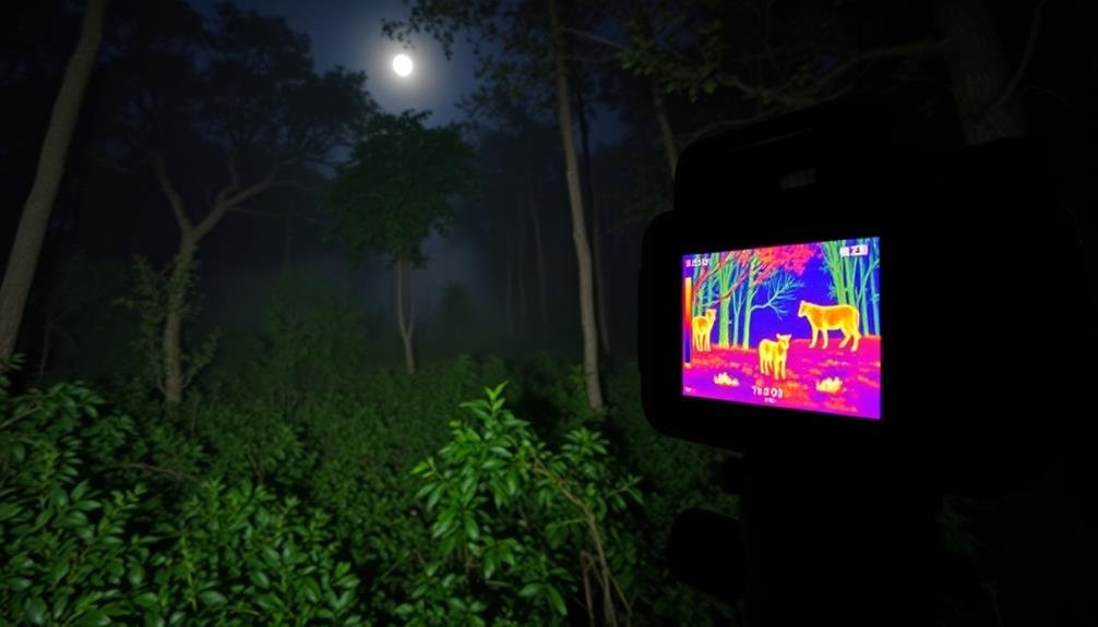
Thermal imaging cameras offer a powerful complement to aerial mapping drones in habitat surveillance. These devices detect heat signatures, allowing you to observe wildlife and track their movements, even in low-light conditions or dense vegetation.
You'll find them particularly useful for nocturnal species monitoring and anti-poaching efforts. When using thermal cameras, you can identify animals by their unique heat patterns. This technology enables you to conduct population surveys more accurately and efficiently than traditional methods.
You'll also be able to detect injured or sick animals that may require intervention, as their body temperatures often differ from healthy individuals. Thermal imaging isn't limited to wildlife observation. You can use it to monitor habitat health by identifying areas of unusual heat, which may indicate forest fires, illegal logging, or other disturbances.
Additionally, you'll find these cameras valuable for evaluating the effectiveness of wildlife corridors and detecting human intrusions in protected areas. To maximize the benefits of thermal imaging, combine it with other surveillance tools.
AI-Powered Wildlife Recognition Software

AI-powered wildlife recognition software represents a game-changing advancement in habitat surveillance. This cutting-edge technology allows you to automatically identify and track various species in their natural habitats with unprecedented accuracy. By analyzing images and videos captured by cameras or drones, these systems can quickly process vast amounts of data, saving you time and resources.
You'll find that AI-powered wildlife recognition software offers several key benefits:
- Increased efficiency: It can analyze thousands of images in minutes, a task that would take humans days or weeks to complete.
- Improved accuracy: Advanced algorithms can distinguish between similar species and identify animals in challenging environments.
- Real-time monitoring: Some systems can provide instant alerts when specific species are detected, enabling rapid response to potential threats or conservation opportunities.
To make the most of this technology, you'll need to choose software that's tailored to your specific needs. Consider factors such as the types of species you're monitoring, the environmental conditions of your study area, and your data processing capabilities.
With the right AI-powered wildlife recognition software, you'll be able to gather valuable insights and make more informed conservation decisions.
Frequently Asked Questions
How Do Conservation Tech Tools Impact Local Communities and Indigenous Populations?
You'll find that conservation tech tools can markedly impact local communities and indigenous populations. They often provide new job opportunities, enhance resource management, and improve wildlife monitoring. However, they may also disrupt traditional practices and raise privacy concerns.
What Are the Ethical Considerations When Using Surveillance Technology for Wildlife Conservation?
You'll need to take into account privacy concerns, potential wildlife disturbance, and data ownership. Make certain you're transparent about your methods, respect local communities, and balance conservation goals with ethical practices. Don't forget to assess long-term impacts on ecosystems.
How Cost-Effective Are These Tools Compared to Traditional Conservation Methods?
You'll find many conservation tech tools are surprisingly cost-effective compared to traditional methods. They often reduce labor costs, increase data accuracy, and cover larger areas. However, you'll need to weigh initial investment against long-term savings for your specific project.
What Training Is Required for Conservationists to Effectively Use These Technologies?
You'll need specialized training to use these technologies effectively. You should learn data collection methods, software operation, and analysis techniques. Don't forget hands-on practice with drones, GPS units, and remote sensing equipment. It's essential to stay updated on advancements.
How Do Weather Conditions Affect the Reliability of Conservation Tech Tools?
You'll find that weather markedly impacts conservation tech tools. Rain can disrupt sensors, fog limits visibility for cameras, and wind affects drones. Extreme temperatures may damage equipment. It's essential you consider these factors when planning surveillance activities.
In Summary
You've now explored three powerful tools for habitat surveillance. By employing aerial mapping drones, you'll gain a bird's-eye view of ecosystems. With thermal imaging cameras, you're able to detect wildlife and track their movements, even in challenging conditions. Finally, AI-powered wildlife recognition software lets you efficiently identify and monitor species. These technologies aren't just gadgets; they're essential allies in your conservation efforts. Embrace them, and you'll revolutionize how you protect and study habitats.
As educators and advocates for responsible drone use, we’re committed to sharing our knowledge and expertise with aspiring aerial photographers.


Leave a Reply