
You're witnessing a revolution in forestry as high-tech drones and advanced remote sensing techniques transform how we map and understand tree species diversity. Drones equipped with high-resolution cameras and sensors now offer a cost-effective alternative to traditional ground surveys. They capture detailed data on tree species, while satellite imagery and LiDAR provide broad-scale assessments. These technologies, combined with AI and machine learning, enable rapid, accurate mapping of forest ecosystems. This information is vital for conservation planning, sustainable forest management, and climate change strategies. As you explore further, you'll uncover how these aerial innovations are reshaping our view of the world's forests.
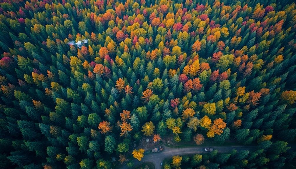
The Rise of Drone Technology

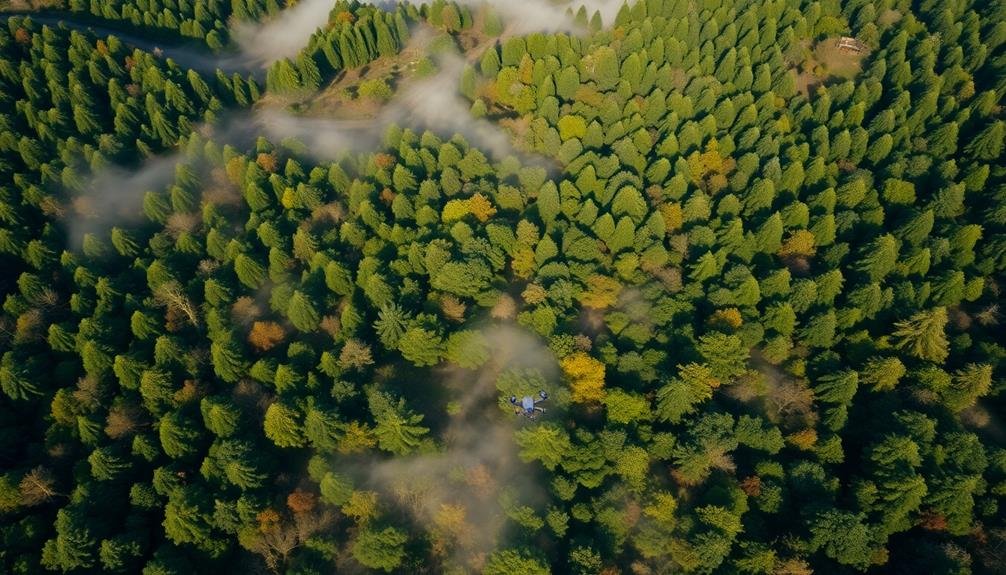
The rapid advancement of drone technology has revolutionized many industries, including forestry and environmental science. You'll find that drones have become an invaluable tool for tree species mapping, offering a cost-effective and efficient alternative to traditional ground-based surveys.
These unmanned aerial vehicles equipped with high-resolution cameras and sensors can cover vast areas of forest in a fraction of the time it would take a ground team. You're able to capture detailed imagery and data from perspectives that were previously inaccessible or prohibitively expensive to obtain.
Modern drones come with features like GPS positioning, obstacle avoidance, and extended flight times, making them ideal for mapping complex forest environments. You can program them to follow specific flight paths, ensuring thorough coverage of the target area.
The data collected by drones is often more accurate and up-to-date than satellite imagery, allowing you to identify individual tree species, assess forest health, and monitor changes over time.
This technology has opened new possibilities for conservation efforts, forest management, and scientific research, enabling you to make more informed decisions about our valuable forest resources.
Understanding Tree Species Diversity

You'll find that tree species diversity plays an essential role in ecosystem health and resilience.
To assess this diversity, you can employ various techniques, including field surveys, remote sensing, and genetic analysis.
Understanding the distribution and composition of tree species helps you develop more effective conservation strategies and manage forest resources sustainably.
Ecological Significance
Understanding tree species diversity is vital for maintaining healthy ecosystems. When you explore a forest, you'll notice that different tree species play unique roles in their environment. These diverse species create a complex web of interactions that support a wide range of wildlife, insects, and microorganisms.
Tree diversity enhances ecosystem resilience. You'll find that forests with varied species are better equipped to withstand disturbances like pests, diseases, and climate change. They're also more efficient at capturing carbon dioxide and producing oxygen, which is essential for mitigating global warming.
Different tree species provide various resources throughout the year. You'll observe how some trees offer early spring flowers for pollinators, while others produce nuts or fruits in the fall for wildlife. This diversity guarantees a steady food supply for animals and promotes biodiversity.
Tree species mapping helps you identify areas of high ecological value and those in need of conservation. By understanding the distribution of tree species, you can make informed decisions about land management, reforestation efforts, and urban planning to preserve and enhance ecosystem services for future generations.
Biodiversity Measurement Techniques
To accurately assess tree species diversity, scientists employ various biodiversity measurement techniques. You'll find that these methods range from traditional field surveys to cutting-edge remote sensing technologies.
Field surveys involve on-the-ground sampling, where researchers identify and count tree species within designated plots. This approach provides detailed, localized data but can be time-consuming and labor-intensive.
Remote sensing techniques have revolutionized biodiversity measurement. You can now use satellite imagery and LiDAR (Light Detection and Ranging) to map large areas quickly. These methods capture spectral signatures and structural characteristics of different tree species, allowing for broad-scale diversity assessments.
DNA barcoding is another powerful tool you'll encounter, enabling rapid species identification through genetic analysis.
You'll also come across biodiversity indices like Shannon's diversity index and Simpson's diversity index. These mathematical tools help you quantify species richness and evenness within a given area.
Conservation Planning Implications
Conservationists rely heavily on tree species diversity data to inform their planning strategies. With accurate tree species maps, you'll be able to identify biodiversity hotspots, assess ecosystem health, and prioritize areas for protection.
These maps help you understand the distribution of rare or endangered species, allowing for targeted conservation efforts and the establishment of protected areas.
You can use tree species diversity information to monitor forest fragmentation and habitat loss. By comparing current maps with historical data, you'll detect changes in species composition over time, helping you assess the impact of climate change and human activities on forest ecosystems.
This knowledge enables you to develop more effective restoration plans and create wildlife corridors to maintain genetic diversity.
Tree species maps also support sustainable forest management practices. You'll be able to identify areas suitable for sustainable timber harvesting while preserving critical habitats.
Additionally, these maps help you plan for climate change adaptation by identifying resilient species and guiding reforestation efforts.
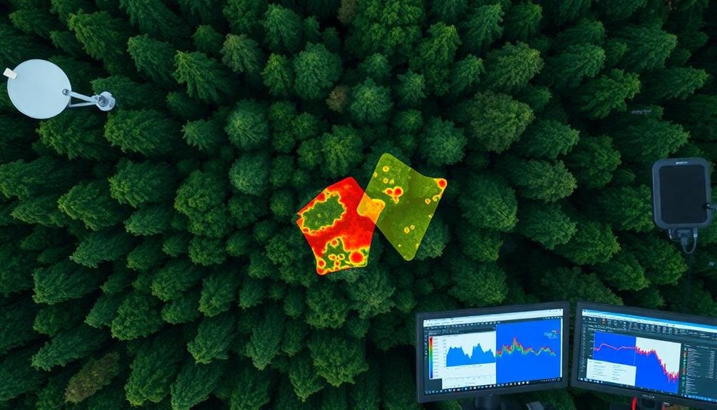
Remote Sensing Techniques

You'll find that satellite imagery analysis is a powerful tool for mapping tree species across large areas.
By examining spectral signatures and vegetation indices, you can identify different species based on their unique reflectance patterns.
LiDAR data applications complement this approach, offering detailed information on tree height, canopy structure, and forest density, which further aids in species classification and distribution mapping.
Satellite Imagery Analysis
Satellite imagery analysis forms the backbone of modern tree species mapping efforts. You'll find that this technique leverages high-resolution images captured by Earth-orbiting satellites to identify and classify different tree species across vast areas.
When you're analyzing satellite imagery for tree species mapping, you'll typically work with multispectral or hyperspectral data. These images capture light reflected from trees in various wavelengths, including visible and infrared spectrums.
You'll use specialized software to process this data, applying algorithms that can distinguish between different tree species based on their unique spectral signatures.
You'll often combine satellite imagery with other data sources, such as LiDAR or field observations, to improve accuracy. Machine learning and artificial intelligence play a vital role in automating the classification process, allowing you to map large forests efficiently.
LiDAR Data Applications
LiDAR, or Light Detection and Ranging, has revolutionized tree species mapping with its unparalleled ability to capture detailed 3D forest structures. You'll find that LiDAR sensors emit laser pulses, measuring the time it takes for the light to bounce back, creating precise point clouds of forest canopies and understory vegetation.
This technology allows you to analyze tree height, crown shape, and canopy density with remarkable accuracy.
When you're mapping tree species using LiDAR data, you'll typically follow these steps:
- Data collection: Acquire high-resolution LiDAR scans of the forest area
- Point cloud processing: Clean and classify the raw LiDAR data
- Feature extraction: Derive tree-specific metrics from the processed data
You can combine LiDAR with other remote sensing techniques, such as multispectral imagery, to enhance species identification.
This fusion approach improves your ability to distinguish between similar tree species by incorporating both structural and spectral information. LiDAR's capacity to penetrate dense canopies also enables you to map understory vegetation and identify seedlings, providing valuable insights into forest regeneration and biodiversity.
Spectral Imaging for Tree Identification

Spectral imaging has revolutionized the field of tree species identification. This technology allows you to capture detailed information about the light reflected from tree canopies across various wavelengths. By analyzing these spectral signatures, you can distinguish between different tree species with remarkable accuracy.
When you use spectral imaging for tree identification, you're fundamentally looking at the unique "fingerprint" of each species. Different trees absorb and reflect light differently due to variations in leaf structure, pigmentation, and chemical composition. You'll find that some species are easier to identify than others, depending on their spectral distinctiveness.
To implement spectral imaging, you'll need specialized sensors mounted on aircraft or satellites. These sensors collect data across multiple spectral bands, including visible light and near-infrared. You'll then process this data using advanced algorithms and machine learning techniques to classify and map tree species over large areas.
The benefits of spectral imaging for tree identification are numerous. You can quickly survey vast forests, monitor biodiversity, track invasive species, and assess forest health.
It's a powerful tool that's transforming how we perceive and manage our forest ecosystems.
Artificial Intelligence in Forestry

Artificial Intelligence (AI) has emerged as a game-changing force in forestry, building upon the foundations laid by spectral imaging and other remote sensing technologies.
You'll find AI algorithms processing vast amounts of data from satellite imagery, LiDAR scans, and drone footage to identify and map tree species with unprecedented accuracy and speed.
These machine learning models can detect subtle patterns in spectral signatures, tree shapes, and forest structures that might elude human observers.
AI's impact on forestry extends beyond mere identification.
You're now able to:
- Predict forest growth and health trends
- Detect early signs of disease or pest infestations
- Optimize timber harvesting and replanting strategies
Challenges in Aerial Species Mapping
You'll encounter significant hurdles when attempting aerial tree species mapping.
Data resolution limitations can impede your ability to distinguish fine details essential for accurate species identification.
You'll also face complexities in differentiating between visually similar species, especially in dense, multi-layered forest canopies.
Data Resolution Limitations
Data resolution constraints pose substantial challenges in aerial tree species mapping. You'll find that the quality of your data directly impacts your ability to accurately identify and classify different tree species from above. As you work with aerial imagery, you'll quickly realize that higher resolution data is essential for distinguishing subtle differences between tree types.
When dealing with data resolution limitations, you'll encounter several key issues:
- Pixel size: Larger pixels can blur the boundaries between individual trees, making it difficult to separate species.
- Spectral resolution: Limited spectral bands may not capture the unique reflectance properties of different tree species, reducing your ability to differentiate them.
- Temporal resolution: Infrequent image captures can miss important seasonal changes in tree appearance, hindering species identification.
You'll need to take these factors into account carefully when planning your aerial mapping project. Investing in high-resolution sensors and frequent data collection can greatly improve your results.
However, you'll also need to balance the cost of advanced technology with your project's budget constraints. By understanding these limitations, you can make informed decisions about data collection methods and analysis techniques to optimize your tree species mapping efforts.
Species Differentiation Complexities
Differentiating tree species from aerial imagery presents a complex challenge, even with high-resolution data. You'll find that similar species can have nearly identical spectral signatures, making them difficult to distinguish. Seasonal variations in leaf color and canopy structure further complicate identification.
To understand the complexities, consider these factors:
| Factor | Challenge |
|---|---|
| Spectral Overlap | Similar species have comparable reflectance patterns |
| Phenology | Leaf color changes throughout seasons |
| Canopy Structure | Varying branch arrangements affect light penetration |
| Mixed Stands | Multiple species within a single pixel |
| Environmental Stress | Drought or disease can alter typical spectral signatures |
You'll need to employ advanced techniques to overcome these hurdles. Machine learning algorithms can help identify subtle differences in spectral patterns. Hyperspectral sensors can capture data across hundreds of narrow wavelength bands, potentially revealing unique species signatures. Multi-temporal imagery allows you to track seasonal changes, aiding in species discrimination. LiDAR data can provide valuable information on tree height and canopy structure, complementing spectral data. By combining these approaches, you'll improve your ability to accurately map tree species, though challenges will persist in complex forest ecosystems.
Data Processing and Analysis
Processing raw data forms the foundation of accurate tree species mapping. You'll need to handle vast amounts of information collected from various sensors and platforms. This data processing stage involves cleaning, calibrating, and organizing the raw data to prepare it for analysis.
Once you've processed the data, you'll move on to the analysis phase. Here, you'll apply advanced algorithms and machine learning techniques to identify and classify different tree species. You'll use spectral signatures, texture patterns, and structural characteristics to differentiate between species.
It's essential to take into account factors such as:
- Seasonal variations in foliage
- Environmental conditions during data collection
- The spatial resolution of your imagery
Your analysis will likely involve a combination of supervised and unsupervised classification methods. You'll need to validate your results using ground-truth data and adjust your models accordingly.
As you refine your techniques, you'll improve the accuracy of your tree species maps.
Applications in Forest Management
Tree species mapping has three primary applications in forest management.
First, it helps you monitor and assess forest health. You'll quickly identify areas affected by pests, diseases, or environmental stressors, allowing for targeted interventions.
Second, it aids in biodiversity conservation. By pinpointing the locations of rare or endangered species, you can implement protective measures and track population changes over time.
Third, tree species mapping enhances sustainable resource management. You'll gain accurate information on timber volumes, growth rates, and species distribution, enabling better harvest planning and reforestation efforts. This data also supports carbon sequestration estimates, vital for climate change mitigation strategies.
Beyond these primary applications, you'll find tree species mapping valuable for fire risk assessment, invasive species detection, and habitat connectivity analysis.
It's an essential tool for urban forestry, too, helping you manage street trees and green spaces effectively.
Conservation Efforts and Biodiversity
Conservation efforts and biodiversity protection benefit immensely from tree species mapping. You'll find that this technology provides essential data for identifying threatened species, monitoring habitat changes, and planning conservation strategies.
By using remote sensing and advanced algorithms, you're able to create detailed maps of forest composition across vast areas, which would be impractical to survey on foot.
These maps help you:
- Identify hotspots of rare or endangered tree species
- Monitor the spread of invasive species
- Track changes in forest composition over time
You'll appreciate how this information guides conservation priorities and resource allocation. It allows you to focus efforts on areas with the highest biodiversity or those facing the greatest threats.
You can also use the data to assess the effectiveness of existing conservation measures and adjust strategies accordingly.
Moreover, tree species mapping supports the creation of wildlife corridors and protected areas. By understanding the distribution of different tree species, you're better equipped to design reserves that encompass a diverse range of habitats.
This approach guarantees that conservation efforts protect not just individual species, but entire ecosystems and the complex web of life they support.
Legal and Ethical Considerations

Several legal and ethical considerations come into play when you're involved in tree species mapping. You'll need to navigate property rights and privacy concerns, especially when using aerial or satellite imagery. Obtaining permission to access private lands for ground-truthing is vital, and you must respect landowners' rights.
Data sharing and ownership present another challenge. You should establish clear agreements on who owns the collected data and how it can be used or shared. Consider open data policies to promote scientific collaboration while protecting sensitive information.
Ethical concerns arise when mapping endangered or commercially valuable species. You'll need to balance transparency with the risk of poaching or illegal logging. It's important to work with conservation authorities to determine appropriate levels of data resolution and access.
Environmental impact is another consideration. Make sure your mapping methods don't harm the ecosystems you're studying. Use non-invasive techniques whenever possible and minimize disturbance to wildlife habitats.
Lastly, be aware of potential misuse of your data. Implement safeguards to prevent exploitation of your findings for harmful purposes, such as facilitating unsustainable resource extraction or discriminatory land-use practices.
Future of Drone-Based Forest Monitoring

As technology advances, drone-based forest monitoring is set to revolutionize tree species mapping. You'll see drones equipped with more sophisticated sensors, including hyperspectral cameras and LiDAR, enabling even more accurate and detailed tree identification. These advancements will allow for real-time data processing and analysis, making forest management more efficient and responsive.
In the coming years, you can expect:
- AI-powered drones that can autonomously navigate complex forest environments and make decisions based on collected data.
- Integration of drone data with satellite imagery and ground-based sensors for an all-encompassing forest monitoring system.
- Development of miniaturized sensors that can detect early signs of disease or stress in individual trees.
You'll also witness the rise of swarm technology, where multiple drones work together to cover larger areas quickly and efficiently. This will be particularly useful for monitoring vast forest regions and detecting changes over time.
As regulations evolve, you'll see increased cooperation between forestry departments, conservation organizations, and tech companies to develop standardized protocols for drone-based forest monitoring. These collaborations will drive innovation and guarantee that the technology is used responsibly and effectively to protect and manage our forests.
Economic Impact of Tree Mapping
The economic landscape of forestry is undergoing a significant transformation due to advanced tree mapping technologies. You'll find that these innovations are revolutionizing how we value and manage forest resources. By providing precise data on tree species, health, and distribution, mapping technologies enable more efficient timber harvesting and sustainable forest management practices.
You're likely to see increased productivity in the forestry sector as companies can now target specific tree species and optimize their harvesting schedules. This precision reduces waste and improves the overall yield of timber operations.
Additionally, you'll notice that accurate tree mapping helps in evaluating carbon sequestration potential, opening up new revenue streams through carbon credit markets.
Conservation efforts also benefit from these technologies. You can now more effectively identify and protect endangered species habitats, leading to better-balanced ecological and economic outcomes.
Furthermore, you'll find that tree mapping data enhances property valuation for both private and public landowners, potentially increasing real estate values in forested areas.
As you explore this field, you'll discover that the economic impact of tree mapping extends beyond forestry, influencing urban planning, agriculture, and climate change mitigation strategies.
Integration With Other Technologies

Tree mapping technologies don't operate in isolation. They're increasingly integrated with other cutting-edge technologies to enhance their capabilities and applications.
You'll find that this integration is revolutionizing the way we comprehend and manage our forests.
One of the most significant integrations is with artificial intelligence and machine learning. These technologies are enabling faster, more accurate identification of tree species from aerial and satellite imagery.
You're now able to process vast amounts of data in a fraction of the time it once took.
Other key integrations include:
- IoT sensors: These devices collect real-time data on tree health, soil conditions, and environmental factors.
- Blockchain technology: It's being used to create transparent, tamper-proof records of tree inventory and carbon credits.
- Virtual and augmented reality: These tools allow you to visualize forest data in immersive 3D environments.
Frequently Asked Questions
How Long Does It Take to Train a Drone Operator for Tree Mapping?
You'll find drone operator training for tree mapping varies widely. It can take anywhere from a few days to several months, depending on your prior experience, the complexity of the equipment, and the specific mapping requirements.
What Specific Drone Models Are Best Suited for Tree Species Identification?
For tree species identification, you'll want drones with high-resolution cameras and multispectral sensors. Consider models like DJI Phantom 4 Multispectral, senseFly eBee X, or Parrot Anafi USA. They're equipped to capture detailed imagery for accurate species mapping.
How Often Should Aerial Tree Species Mapping Be Conducted for Accurate Results?
You'll want to conduct aerial tree species mapping annually for most accurate results. However, you can adjust frequency based on your specific needs, forest growth rates, and any major environmental changes you're tracking in your area.
Can Tree Mapping Drones Operate Effectively in Extreme Weather Conditions?
You'll find that tree mapping drones struggle in extreme weather. They can't operate well in heavy rain, strong winds, or intense cold. It's best to use them in calm conditions for accurate results and safe operation.
What Is the Average Cost per Acre for Conducting a Drone-Based Tree Survey?
You'll find drone-based tree surveys typically cost between $10 and $50 per acre. However, your exact price will vary based on factors like survey area size, terrain complexity, and desired data resolution. It's best to get customized quotes.
In Summary
You've seen how drone technology is revolutionizing tree species mapping. It's not just about counting trees anymore; it's about understanding our forests in unprecedented detail. As you embrace these high-tech tools, remember that they're reshaping forestry, conservation, and land management. You'll likely witness even more advanced integration of AI, spectral imaging, and drones in the coming years. Keep an eye on the sky—it's where the future of forest monitoring is taking flight.
As educators and advocates for responsible drone use, we’re committed to sharing our knowledge and expertise with aspiring aerial photographers.


Leave a Reply