
Tracking wildlife health from above offers numerous advantages for conservation efforts. You'll gain non-invasive population assessments, early disease detection capabilities, and large-scale habitat monitoring. It's a cost-effective approach that reduces human-wildlife conflicts while providing real-time data on species distribution and migration patterns. By using aerial surveys, drones, and satellites, you can minimize research impact on sensitive ecosystems. This bird's-eye view allows for efficient monitoring of vast areas, informing conservation strategies and resource allocation. From identifying environmental stressors to mapping ecosystem changes, aerial wildlife tracking revolutionizes our understanding of animal health and habitat dynamics. Discover how this innovative approach is reshaping wildlife management.
Non-Invasive Population Health Assessment

Through non-invasive population health assessment, wildlife researchers can monitor the well-being of animal groups without causing stress or disruption. You'll find this approach particularly valuable for studying sensitive or endangered species.
By using aerial surveys, remote sensing technologies, and environmental DNA sampling, you can gather essential data on population size, distribution, and overall health status.
Aerial surveys allow you to cover vast areas quickly, capturing high-resolution images and thermal data to detect animals and assess their physical condition. You'll spot signs of disease, malnutrition, or injury from a safe distance.
Remote sensing technologies, such as satellite imagery and LiDAR, help you analyze habitat quality and changes over time, providing insights into potential health threats.
Environmental DNA sampling lets you collect genetic material from water, soil, or air to identify species presence and estimate population sizes. You can even detect pathogens or parasites affecting wildlife populations.
Early Disease Detection Capabilities
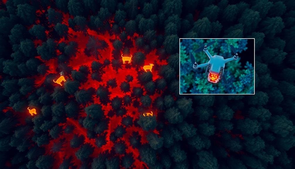
Early disease detection capabilities are vital for effective wildlife health management. You'll find that these capabilities allow researchers and conservationists to identify potential health threats before they become widespread. By using advanced technologies like thermal imaging, high-resolution cameras, and remote sensing, you can spot signs of illness in wildlife populations from above.
This aerial approach offers a significant advantage, as it enables you to cover vast areas quickly and efficiently.
With early disease detection, you're able to:
- Identify disease outbreaks in their initial stages
- Implement targeted intervention strategies
- Prevent the spread of infections to other populations
- Protect endangered species from potentially devastating health threats
You'll appreciate how this proactive approach can save time, resources, and most importantly, animal lives. By detecting diseases early, you can initiate swift responses, such as quarantine measures or targeted treatments.
This not only helps maintain the health of wildlife populations but also reduces the risk of zoonotic diseases that could potentially affect human health. Early disease detection capabilities are an essential tool in your wildlife health management arsenal, offering a powerful means to safeguard biodiversity and ecosystem balance.
Large-Scale Habitat Monitoring

When you're tracking wildlife health on a large scale, habitat monitoring becomes essential.
You'll need to map ecosystem changes over time, assess biodiversity hotspots to prioritize conservation efforts, and identify areas of habitat fragmentation that may impact animal populations.
These monitoring efforts provide valuable insights into the overall health of wildlife and their environments, helping you make informed decisions for conservation and management.
Mapping Ecosystem Changes
Numerous ecosystems worldwide are undergoing rapid changes due to climate shifts, human activities, and natural disasters. Tracking these changes from above allows you to create extensive maps that reveal the extent and pace of ecosystem transformations.
By using satellite imagery, aerial photography, and remote sensing technologies, you'll gain a bird's-eye view of large-scale habitat alterations. These maps provide vital data for wildlife conservation efforts, helping you identify areas of concern and prioritize protection strategies.
You'll be able to monitor deforestation, urbanization, and agricultural expansion, which directly impact wildlife populations. Additionally, you can track natural phenomena like wildfires, floods, and droughts that reshape habitats.
Here's why mapping ecosystem changes is essential:
- Identifies wildlife corridors and migration routes
- Reveals habitat fragmentation patterns
- Monitors the spread of invasive species
- Assesses the effectiveness of conservation measures
Assessing Biodiversity Hotspots
Biodiversity hotspots are essential areas that harbor a high concentration of unique species and face significant threats. When you're tracking wildlife health from above, evaluating these hotspots becomes a vital part of your mission. You'll use advanced remote sensing technologies to identify and monitor these critical habitats on a large scale.
From your aerial vantage point, you can map the distribution of various plant and animal species across vast landscapes. This bird's-eye view allows you to detect patterns and changes that might be invisible from the ground. You'll use multispectral imaging to analyze vegetation health, identify different species, and spot signs of habitat degradation.
By focusing on biodiversity hotspots, you're prioritizing areas that need immediate conservation attention. You'll track the movement of endangered species, evaluate the impact of human activities, and identify potential corridors for wildlife migration. This data helps conservationists make informed decisions about protected area management and habitat restoration efforts.
Your aerial evaluations also provide valuable insights into ecosystem health and resilience. You'll monitor how these hotspots respond to climate change, invasive species, and other environmental pressures, helping to guide adaptive management strategies for long-term biodiversity conservation.
Identifying Habitat Fragmentation
Habitat fragmentation stands out as a major threat to wildlife populations worldwide. As habitats are divided into smaller, isolated patches, animals face numerous challenges.
You'll find that tracking wildlife health from above provides a unique perspective on this issue. Aerial surveys and satellite imagery allow you to identify fragmented areas quickly and efficiently.
By using these tools, you're able to:
- Detect changes in landscape patterns over time
- Identify potential wildlife corridors
- Assess the size and quality of remaining habitat patches
- Monitor the spread of human development and infrastructure
With this information, you can make informed decisions about conservation efforts and habitat restoration.
You'll be able to pinpoint areas where wildlife populations are most at risk due to fragmentation. This knowledge is essential for developing targeted strategies to mitigate the effects of habitat loss.
Cost-Effective Wildlife Management

You'll find that cost-effective wildlife management brings significant benefits to conservation efforts.
By implementing remote sensing technologies, you can drastically reduce field personnel costs while maintaining thorough wildlife monitoring.
These advancements also enable you to conduct efficient population surveys across vast areas, providing accurate data without the need for extensive on-site presence.
Reduced Field Personnel Costs
One of the most significant advantages of wildlife health tracking systems is their ability to dramatically reduce field personnel costs. You'll find that these advanced technologies can replace many on-the-ground tasks traditionally performed by field researchers.
By using drones, satellite imagery, and remote sensors, you're able to gather data from vast areas without sending teams into potentially dangerous or hard-to-reach locations.
This approach not only saves money but also increases efficiency. You'll be able to monitor more animals over larger territories with fewer staff members.
The reduced need for physical presence in the field translates to:
- Lower travel and accommodation expenses
- Decreased equipment and supply costs
- Minimized risk of workplace injuries and associated insurance costs
- Reduced training and onboarding expenses for field personnel
Efficient Population Surveys
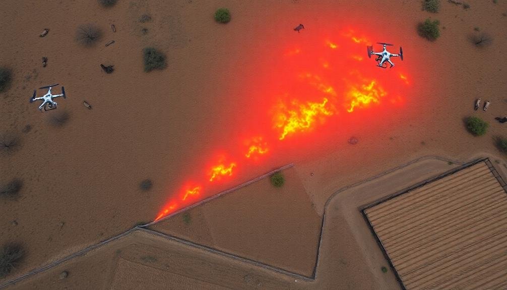
Wildlife health tracking systems also revolutionize population surveys, making them more efficient and cost-effective. You'll find that aerial surveillance using drones or satellites can cover vast areas in a fraction of the time it takes ground teams. This technology allows you to conduct regular, thorough surveys without disturbing animals or risking human safety in challenging terrains.
With high-resolution imagery and thermal sensors, you can accurately count and identify species, even in dense vegetation or remote locations. You'll capture data on population sizes, distribution patterns, and habitat use with unprecedented precision. This information is vital for making informed management decisions and allocating resources effectively.
By automating data collection and analysis, you'll reduce human error and bias in your surveys. Machine learning algorithms can quickly process large datasets, identifying trends and anomalies that might be missed by manual methods. You can also monitor changes over time more easily, tracking population fluctuations and responding promptly to potential threats.
These efficient surveys enable you to optimize conservation efforts, target interventions where they're most needed, and maximize the impact of your wildlife management budget.
Reducing Human-Wildlife Conflict
In light of growing human populations and shrinking habitats, reducing human-wildlife conflict has become a vital conservation priority. Aerial tracking can play an essential role in mitigating these conflicts by providing real-time data on animal movements and behavior. You'll find that this information is invaluable for wildlife managers and local communities alike.
By monitoring wildlife from above, you can identify potential conflict hotspots before they escalate. This allows for proactive measures, such as setting up early warning systems or implementing temporary barriers. You'll also be able to track the effectiveness of conflict mitigation strategies over time, adjusting them as needed for best results.
Aerial health tracking offers unique insights into human-wildlife interactions:
- Identify patterns in animal movements near human settlements
- Detect changes in behavior that may indicate stress or habituation
- Monitor the spread of diseases that could affect both wildlife and humans
- Assess the impact of human activities on wildlife populations
Tracking Migration Patterns

You'll gain valuable insights into wildlife behavior by tracking seasonal movements.
These patterns reveal how animals adapt to changing environments and food availability throughout the year.
Seasonal Movement Insights
Through advanced tracking technologies, researchers can now unravel the mysteries of seasonal wildlife movements. You'll be amazed at how these insights help us understand animal behavior and adapt conservation strategies.
By monitoring wildlife from above, we're able to observe patterns that weren't visible before. You can see how animals respond to changing temperatures, food availability, and breeding cycles throughout the year.
Seasonal movement data provides vital information for wildlife management:
- Identifying critical habitats that need protection
- Predicting potential human-wildlife conflicts
- Understanding the impact of climate change on migration routes
- Developing more effective conservation plans
You'll find that this information isn't just valuable for scientists. It's also essential for policymakers, land managers, and local communities.
By tracking seasonal movements, we can better prepare for the arrival of migratory species and minimize disruptions to both wildlife and human activities. You'll appreciate how this knowledge helps us coexist more harmoniously with nature.
As you explore the world of wildlife tracking, you'll discover that seasonal movement insights are key to preserving biodiversity and ensuring the long-term survival of countless species.
Population Distribution Changes
Tracking migration patterns reveals fascinating changes in population distribution over time. You'll discover how wildlife populations shift across landscapes, responding to environmental factors and human influences. By monitoring these changes, you can identify trends that impact ecosystem health and biodiversity.
You'll observe how some species expand their ranges while others contract. Climate change often drives these shifts, forcing animals to seek new habitats as their traditional homes become less suitable.
You'll also notice how urban development and habitat fragmentation affect population distributions, creating isolated pockets of wildlife or pushing species into new areas.
As you track these changes, you'll gain valuable insights into the resilience and adaptability of different species. You might witness the colonization of new territories or the abandonment of once-thriving habitats.
This information helps you predict future population trends and identify potential conservation hotspots.
Identifying Environmental Stressors

In the domain of wildlife health tracking, identifying environmental stressors is essential.
You'll find that aerial observations provide a unique perspective on the factors affecting wildlife populations. From above, you can spot signs of habitat fragmentation, pollution, and climate change impacts that mightn't be visible from the ground. This bird's-eye view allows you to assess large areas quickly and efficiently, identifying potential threats to wildlife health.
When you're tracking wildlife health from above, you'll want to look for:
- Changes in vegetation patterns
- Water body alterations or pollution
- Signs of human encroachment
- Unusual animal behavior or distribution
Assessing Species Distribution

From high above, you'll find that evaluating species distribution is an important component of wildlife health tracking. Aerial surveys provide a thorough view of animal populations across vast landscapes, allowing you to map their locations and movements with unprecedented accuracy.
You'll be able to identify habitat preferences, migration patterns, and changes in population density over time. By using advanced imaging technology and GPS tracking, you can pinpoint the exact locations of different species and monitor their interactions with their environment.
This data helps you understand how animals respond to environmental changes, human activities, and disease outbreaks. You'll also be able to detect early signs of population decline or expansion, which can indicate underlying health issues or ecological imbalances.
Moreover, evaluating species distribution from above enables you to identify vital habitats, breeding grounds, and feeding areas that require protection. This information is essential for developing effective conservation strategies and managing wildlife populations sustainably.
You'll also be able to track invasive species and their impact on native fauna, allowing for timely intervention to preserve ecosystem health.
Minimizing Research Impact

Researchers must tread lightly when studying wildlife to guarantee their presence doesn't negatively affect the animals they're observing. Aerial tracking methods offer a unique advantage in this regard. By using drones, satellites, or aircraft, you can monitor wildlife from a safe distance, reducing stress on the animals and minimizing habitat disturbance.
These remote sensing techniques allow you to collect valuable data without physically interacting with the subjects. You'll avoid introducing human scent, altering animal behavior, or accidentally transmitting diseases. This non-invasive approach is particularly significant when studying endangered species or those sensitive to human presence.
Consider these benefits of aerial wildlife health tracking:
- Reduced habitat disturbance
- Decreased stress on animals
- Lower risk of disease transmission
- Ability to observe natural behaviors
Real-Time Data Collection

Real-time data collection takes aerial wildlife health tracking to the next level. As you fly over habitats, sophisticated sensors and cameras capture essential information about animal populations instantly. This immediate data stream allows researchers to make quick decisions and respond to emerging health threats promptly.
You'll find that real-time tracking provides a dynamic picture of wildlife health. It enables you to monitor changes in animal behavior, detect disease outbreaks, and identify environmental stressors as they occur. With this up-to-the-minute information, you can initiate rapid interventions to protect endangered species or contain potential epidemics.
The technology also enhances your ability to track migratory patterns and population movements. You'll receive continuous updates on animal locations, helping you understand how health issues might spread across different regions.
Real-time data collection improves the accuracy of your research by reducing the time gap between observation and analysis.
Conservation Strategy Development

Building on real-time data collection, conservation strategy development becomes a dynamic and responsive process.
You'll find that aerial wildlife health tracking provides invaluable insights for creating effective conservation plans. By analyzing data from above, you can identify threats, population trends, and habitat changes that inform your strategies.
You'll be able to adapt your conservation efforts quickly based on up-to-date information. This agility is essential in addressing emerging issues before they become critical. With aerial tracking, you're not just reacting to problems; you're anticipating and preventing them.
Consider these key benefits of aerial tracking for conservation strategy development:
- Rapid identification of disease outbreaks or environmental stressors
- Accurate mapping of migration patterns and habitat use
- Early detection of human-wildlife conflicts
- Efficient allocation of resources based on real-time needs
Frequently Asked Questions
How High Do Drones Typically Fly When Tracking Wildlife?
You'll find that drones tracking wildlife typically fly between 50 to 400 feet above ground level. This range allows them to gather detailed imagery without disturbing animals. However, exact heights can vary based on specific research needs.
What Types of Cameras or Sensors Are Used in Aerial Wildlife Monitoring?
You'll find wildlife monitoring drones equipped with various cameras and sensors. They often use high-resolution optical cameras, thermal imaging sensors, and multispectral cameras. Some even carry LiDAR systems for 3D mapping or specialized acoustic sensors for detecting animal calls.
Can Aerial Tracking Distinguish Between Individual Animals Within a Species?
Yes, you can use aerial tracking to distinguish individual animals within a species. High-resolution cameras and thermal imaging can capture unique markings, scars, or patterns. It's also possible to track tagged animals using radio telemetry from aircraft.
How Do Weather Conditions Affect the Accuracy of Aerial Wildlife Tracking?
You'll find that weather conditions greatly impact aerial wildlife tracking accuracy. Rain, fog, and strong winds can obstruct visibility and disrupt sensor readings. Clear, calm days are ideal for obtaining precise data on animal movements and populations.
Are There Legal Restrictions on Using Drones for Wildlife Monitoring?
Yes, you'll encounter legal restrictions when using drones for wildlife monitoring. You'll need permits, must follow airspace regulations, and respect wildlife protection laws. Don't forget to check local and national rules before flying your drone.
In Summary
You've seen how tracking wildlife health from above offers numerous advantages. It's a game-changer for conservation efforts, providing non-invasive monitoring, early disease detection, and large-scale habitat assessment. You'll find it's cost-effective and minimizes human impact on animals. By embracing this approach, you're supporting real-time data collection and better conservation strategies. Remember, it's not just about observing wildlife; it's about safeguarding their future and reducing conflicts with humans.
As educators and advocates for responsible drone use, we’re committed to sharing our knowledge and expertise with aspiring aerial photographers.


Leave a Reply