You'll find three powerful photography-based tools transforming construction site measurements. Photogrammetry software creates accurate 3D models from overlapping photos, saving time and reducing errors. LiDAR-equipped drones combine aerial mobility with laser technology, ideal for capturing complex topography and vegetation-dense areas. 360-degree cameras offer extensive site views, enabling remote inspections and progress tracking. These tools provide precise data collection, real-time analysis, and improved decision-making capabilities. Each option excels in different scenarios, from detailed structural mapping to broad landscape surveys. By exploring these innovative solutions, you'll discover how they can revolutionize your construction project management and efficiency.
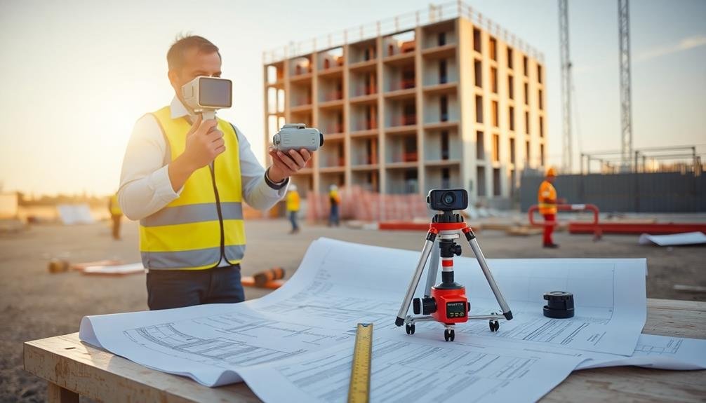
Photogrammetry Software

Precision meets innovation in photogrammetry software, revolutionizing construction site measurements. This technology allows you to create accurate 3D models and measurements from photographs, saving time and reducing errors on the job site.
You'll find various photogrammetry software options tailored for construction professionals. These tools use complex algorithms to analyze multiple images and generate detailed point clouds, meshes, and orthophotos.
With just a smartphone or drone, you can capture images of your site and process them into highly accurate digital representations.
Key features to look for include automatic tie point detection, georeferencing capabilities, and seamless integration with CAD software. Some popular options offer cloud-based processing, allowing you to access your projects from anywhere.
When using photogrammetry software, verify you capture overlapping images from different angles for best results.
You'll also want to take into account the lighting conditions and use ground control points for increased accuracy.
LiDAR-Equipped Drones

While photogrammetry software relies on cameras, LiDAR-equipped drones take aerial surveying to new heights. These cutting-edge devices combine the mobility of drones with the precision of Light Detection and Ranging (LiDAR) technology.
You'll find that LiDAR drones emit laser pulses to measure distances and create highly accurate 3D point clouds of construction sites.
With LiDAR drones, you can quickly capture detailed topographic data, even in areas with dense vegetation or complex structures. They're particularly useful for large-scale projects, as they can cover extensive areas in a fraction of the time it'd take for ground-based surveys.
You'll appreciate their ability to penetrate tree canopies and detect subtle terrain variations, making them ideal for site planning and earthwork calculations.
These drones offer real-time data collection, allowing you to make informed decisions on the spot. They're also less affected by lighting conditions than traditional photogrammetry, ensuring consistent results regardless of the time of day.
360-Degree Cameras

Innovation in construction site measurement extends to 360-degree cameras, offering a broad view of project areas. These cameras capture a complete spherical image, allowing you to see every angle of a space in a single shot. You'll find them invaluable for documenting site conditions, progress tracking, and creating virtual walkthroughs.
To use a 360-degree camera effectively, mount it on a tripod or helmet for stability. You can then capture high-resolution images or videos that provide a thorough view of the construction site. These images are particularly useful for remote inspections, reducing the need for frequent on-site visits.
Many 360-degree cameras integrate with specialized software for measurements and analysis. You can extract dimensions, calculate areas, and even create 3D models from the captured images. This functionality proves especially useful for as-built documentation and identifying discrepancies between plans and actual construction.
When selecting a 360-degree camera, consider factors like image resolution, durability, and compatibility with your existing workflow. You'll also want to verify it can withstand harsh construction environments and provide accurate data for your measurement needs.
Frequently Asked Questions
How Do Weather Conditions Affect the Accuracy of Photographic Measurement Tools?
Weather conditions can greatly impact your photographic measurements' accuracy. You'll find that rain, snow, and fog reduce visibility, while strong sunlight causes glare. Wind can shake your camera, and extreme temperatures may affect equipment performance.
What Training Is Required to Operate These Advanced Measurement Technologies?
You'll need specialized training to operate advanced measurement technologies. You should learn software basics, camera operation, and data interpretation. It's essential you understand calibration techniques and error correction. Hands-on experience and ongoing education are vital.
Can These Tools Integrate With Existing Construction Management Software?
You'll find that many of these tools can integrate with popular construction management software. They often offer APIs or direct integrations, allowing you to seamlessly sync data, measurements, and images with your existing project management systems.
How Do Costs Compare Between Traditional Measurement Methods and Photographic Technologies?
You'll find photographic technologies often cost more upfront but save money long-term. They're faster, more accurate, and reduce labor costs. Traditional methods are cheaper initially but can lead to costly errors and inefficiencies over time.
Are There Any Legal Considerations When Using Drones for Construction Site Measurements?
You'll need to take into account privacy laws, airspace regulations, and licensing requirements when using drones for construction measurements. Don't forget to obtain necessary permits and follow local guidelines to avoid legal issues during your project.
In Summary
You've now explored three powerful tools for construction site measurements using photography. Whether you're using photogrammetry software, LiDAR-equipped drones, or 360-degree cameras, you'll find these technologies can greatly improve your accuracy and efficiency. By adopting these innovative solutions, you're not just keeping up with the industry; you're staying ahead of the curve. Don't hesitate to incorporate these tools into your workflow – they'll transform how you measure and analyze your construction sites.
As educators and advocates for responsible drone use, we’re committed to sharing our knowledge and expertise with aspiring aerial photographers.


Leave a Reply