
Field imagery technology offers three powerful soil analysis tips. First, use multispectral imagery to assess nutrient levels, identifying deficiencies without extensive sampling. Capture light reflectance across wavelengths to reveal crop health patterns and inform fertilization strategies. Second, employ thermal mapping to analyze soil moisture. Thermal cameras create infrared images that correlate temperature variations with moisture content, helping you spot drainage issues and optimize irrigation. Third, utilize vegetation indices like NDVI, EVI, and SAVI to evaluate plant vigor and soil health. These spectral data-based indices track changes over time, guiding your crop management decisions. Discover how these cutting-edge techniques can transform your soil analysis approach.
Multispectral Imagery for Nutrient Assessment

How can multispectral imagery revolutionize nutrient assessment in soil analysis? By capturing light reflectance across various wavelengths, this technology provides valuable insights into your soil's nutrient content. You'll be able to identify deficiencies and excesses without extensive physical sampling.
Multispectral sensors mounted on drones or satellites collect data in visible and near-infrared spectra. These images reveal patterns in crop health and soil composition that aren't visible to the naked eye. You can use this information to create detailed nutrient maps of your fields, highlighting areas that need attention.
Key nutrients like nitrogen, phosphorus, and potassium have distinct spectral signatures. By analyzing these signatures, you'll pinpoint specific nutrient issues and tailor your fertilization strategy accordingly. This precision approach reduces waste and optimizes crop yields.
You'll also detect early signs of nutrient stress before visible symptoms appear. This allows for proactive management, preventing yield losses and maintaining crop quality.
With multispectral imagery, you're equipped to make data-driven decisions about soil amendments and fertilizer applications, leading to more sustainable and efficient farming practices.
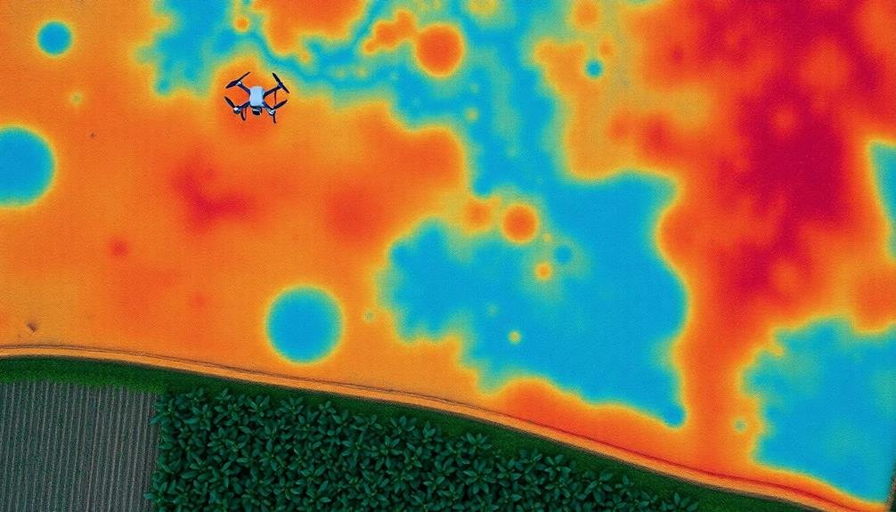
Thermal Mapping of Soil Moisture
While nutrient levels are essential, understanding soil moisture is equally important for ideal crop management.
Thermal mapping offers a powerful tool to assess soil moisture across your fields. You'll need a thermal camera, either handheld or drone-mounted, to capture infrared images of your land.
As you collect thermal imagery, you'll notice temperature variations that correlate with moisture content. Cooler areas typically indicate higher moisture levels, while warmer spots suggest drier soil.
You can use this information to identify drainage issues, irrigation inefficiencies, or areas prone to drought stress.
To interpret the data, you'll need specialized software that converts thermal images into moisture maps.
These maps will help you make informed decisions about irrigation scheduling, planting dates, and crop selection. You can also use them to pinpoint areas that may benefit from soil amendments or drainage improvements.
Vegetation Indices for Soil Health
Vegetation indices offer a powerful lens into soil health, providing valuable insights beyond what's visible to the naked eye. These indices use spectral information from satellite or drone imagery to assess plant vigor and density, which directly correlate with soil conditions.
You'll find the Normalized Difference Vegetation Index (NDVI) particularly useful. It measures the difference between near-infrared and red light reflectance, indicating plant health and biomass. A high NDVI suggests robust vegetation and, by extension, good soil health.
Don't overlook the Enhanced Vegetation Index (EVI), which improves upon NDVI by accounting for atmospheric conditions and canopy background noise. It's especially effective in areas with dense vegetation.
For soil-specific analysis, consider the Soil Adjusted Vegetation Index (SAVI). It minimizes soil brightness influences, making it ideal for areas with sparse vegetation cover.
When interpreting these indices, remember that they're proxies for soil health. High values generally indicate fertile, well-structured soils with good water retention.
However, you'll need to combine this data with other soil analysis methods for a thorough assessment. Regular monitoring of vegetation indices can help you track changes in soil health over time, enabling timely interventions when needed.
Frequently Asked Questions
How Often Should Soil Analysis Using Field Imagery Technology Be Conducted?
You should conduct soil analysis using field imagery technology at least once per growing season. However, you'll get more accurate results if you do it multiple times, especially before planting and after harvest. It's essential for ideal crop management.
What Are the Cost Implications of Implementing Field Imagery Technology?
You'll face upfront costs for equipment and software, but you'll save money long-term. You're reducing labor, optimizing inputs, and increasing yields. Don't forget ongoing expenses like data storage and potential subscription fees for analysis services.
Can Field Imagery Technology Replace Traditional Soil Sampling Methods Entirely?
While field imagery technology can't fully replace traditional soil sampling, it can greatly reduce your need for it. You'll still want some physical samples, but you'll be able to target your sampling more efficiently and cost-effectively.
How Accurate Is Field Imagery Technology Compared to Laboratory Soil Analysis?
While field imagery technology can provide valuable insights, it's not as accurate as laboratory soil analysis. You'll find it's a useful complementary tool, but you shouldn't rely on it exclusively for precise soil composition measurements.
What Training Is Required to Effectively Use and Interpret Field Imagery Data?
You'll need training in remote sensing, GIS, and data analysis. Learn to operate imaging devices and interpret spectral data. Enroll in courses or workshops on field imagery interpretation. Practice with real-world datasets to hone your skills.
In Summary
You've now got powerful tools at your fingertips to analyze your soil like never before. With multispectral imagery, you'll pinpoint nutrient needs. Thermal mapping will reveal moisture patterns. And vegetation indices will give you a clear picture of overall soil health. Don't hesitate to embrace these technologies. They'll transform your understanding of your fields and help you make smarter, more targeted decisions for ideal crop management and yield improvement.
As educators and advocates for responsible drone use, we’re committed to sharing our knowledge and expertise with aspiring aerial photographers.


Leave a Reply