
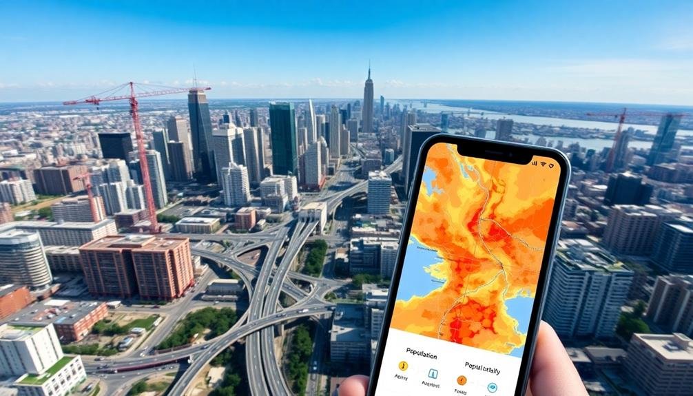
Digital surveys can reveal a wealth of information about city growth. You'll see patterns of urban sprawl through aerial mapping and population density analysis. These tools track infrastructure development, monitor green spaces, and identify traffic patterns in real-time. They'll show you how zoning and land use are changing, often uncovering areas of rapid expansion or decline. You can even detect urban heat islands, helping planners mitigate environmental impacts. By combining technologies like satellite imagery, LiDAR, and IoT sensors, digital surveys provide a thorough view of how cities evolve. This data-driven approach offers invaluable insights for sustainable urban development and smarter city planning.
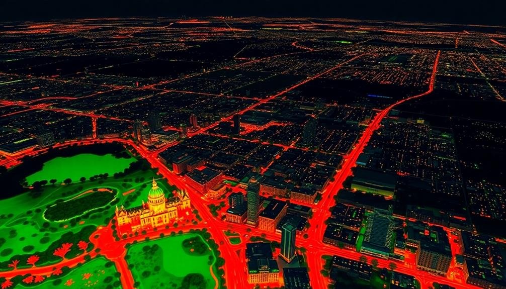
Aerial Mapping of Urban Sprawl
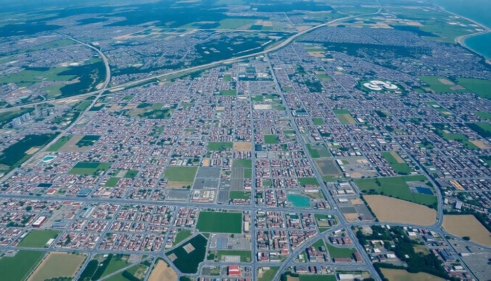
From high above, aerial mapping techniques have revolutionized how we track and understand urban sprawl. You'll find that modern digital surveys employ sophisticated remote sensing technologies, including LiDAR and high-resolution satellite imagery, to capture detailed snapshots of expanding cityscapes.
These tools allow urban planners and researchers to measure changes in land use, building density, and infrastructure development over time.
When you analyze aerial maps, you'll notice patterns of growth that mightn't be apparent from ground level. You can identify new suburban developments, track the conversion of agricultural land to residential areas, and monitor the expansion of transportation networks.
Digital surveys also enable you to quantify green spaces, assess urban heat islands, and evaluate the impact of sprawl on local ecosystems.
Population Density Analysis

When you analyze population density in urban areas, you'll find distinct patterns emerge.
You'll notice hotspots and urban cores where people cluster tightly, contrasting with suburban sprawl patterns that show a more dispersed population.
As you examine vertical growth trends, you'll see how cities are building upwards to accommodate increasing populations in limited space.
Hotspots and Urban Cores
Population density analysis reveals a city's beating heart. Through digital surveys, you can identify urban hotspots and core areas where people concentrate. These high-density zones often indicate city centers, business districts, or popular residential neighborhoods.
You'll notice that hotspots tend to form around key amenities and infrastructure. Transit hubs, shopping districts, and employment centers typically attract higher population densities. By mapping these areas, you can visualize the city's structure and understand its growth patterns.
Urban cores are particularly interesting, as they're often the oldest parts of a city with the highest concentration of activities. You'll find that these areas usually have mixed-use development, combining residential, commercial, and cultural spaces.
Digital surveys can help you track how these cores evolve over time, expanding or shifting as the city grows.
Suburban Sprawl Patterns
Moving outward from the urban core, digital surveys reveal a different story of city growth.
You'll notice that suburban sprawl patterns emerge as population density gradually decreases. These digital tools allow you to analyze how cities expand horizontally, often consuming previously undeveloped land or rural areas.
You can track the development of residential neighborhoods, shopping centers, and business parks that characterize suburban growth.
Digital surveys help you identify the formation of satellite communities and edge cities, which often spring up along major transportation corridors.
You'll see how infrastructure, such as roads and utilities, extends outward to support these expanding areas.
Vertical Growth Trends
Digital surveys reveal a stark contrast in urban growth patterns when you shift your focus to vertical development. You'll notice that many cities are embracing skyscrapers and high-rise buildings to accommodate growing populations without expanding their footprints. This vertical growth trend is particularly evident in dense urban cores where land is scarce and valuable.
As you analyze population density data from digital surveys, you'll see hotspots of intense vertical development in major metropolitan areas. These areas often show exponential increases in population density over time, with some city blocks housing thousands of residents in a single building.
You'll find that this trend isn't limited to residential structures; mixed-use developments combining living spaces, offices, and retail are becoming increasingly common.
Digital surveys also highlight the impact of zoning changes on vertical growth. You'll observe how cities are adapting their regulations to encourage taller buildings and higher density in specific areas.
This data can help you predict future growth patterns and identify potential areas for urban renewal or redevelopment. By examining these vertical trends, you'll gain valuable insights into how cities are evolving to meet the challenges of urbanization and limited space.
Infrastructure Development Tracking
You'll find that digital surveys revolutionize infrastructure development tracking through real-time progress monitoring.
As you implement these tools, you can instantly identify construction milestones and compare them against project timelines.
This ability to spot development bottlenecks quickly allows you to address issues promptly, ensuring smoother project execution and more efficient urban growth.
Real-Time Progress Monitoring
Through real-time progress monitoring, city planners and developers can track infrastructure projects with unprecedented accuracy and efficiency. You'll find that digital tools now allow for continuous updates on construction progress, resource allocation, and potential delays. This real-time data enables quick decision-making and proactive problem-solving, ensuring projects stay on track and within budget.
You can leverage various technologies to achieve this level of monitoring. Drones provide aerial surveys, while IoT sensors offer ground-level data. Mobile apps allow workers to report progress instantly, creating a thorough picture of the project's status.
| Technology | Data Collected | Benefits |
|---|---|---|
| Drones | Aerial imagery | Site-wide overview |
| IoT Sensors | Environmental data | Early warning system |
| Mobile Apps | Progress reports | Real-time updates |
Identifying Development Bottlenecks
With digital surveys and tracking tools, identifying development bottlenecks in infrastructure projects has become more efficient than ever. You can now pinpoint exactly where delays and issues are occurring in real-time.
These tools allow you to monitor various stages of development simultaneously, from planning and design to construction and implementation.
By analyzing the data collected through digital surveys, you'll spot patterns and recurring problems that hinder progress. You can track resource allocation, workforce productivity, and equipment utilization to identify inefficiencies.
These insights empower you to make data-driven decisions to optimize project workflows and remove obstacles.
Digital tools also help you visualize complex project timelines and dependencies. You'll quickly see which tasks are falling behind schedule and how they impact the overall project.
This allows for proactive problem-solving and resource reallocation to keep projects on track. Additionally, you can compare performance across different infrastructure projects, identifying systemic issues that may be affecting multiple developments.
Green Space Monitoring
How can cities effectively monitor their green spaces in the digital age? You'll find that digital surveys have revolutionized the way urban planners track and manage green areas. By using satellite imagery, drones, and GIS technology, you can now map and analyze parks, urban forests, and other green spaces with unprecedented accuracy.
You'll be able to monitor changes in vegetation cover, identify areas of deforestation, and assess the health of urban ecosystems. These digital tools allow you to track the impact of urbanization on green spaces and make data-driven decisions to preserve biodiversity.
You can also use AI algorithms to analyze large datasets and predict future trends in green space development. Moreover, you'll find that digital surveys enable real-time monitoring of air quality, temperature, and other environmental factors in green areas.
This data helps you understand the cooling effect of urban parks and their role in mitigating the urban heat island effect. By leveraging these digital tools, you can create more sustainable and livable cities, ensuring that green spaces continue to thrive amidst rapid urban growth.
Traffic Pattern Identification

Traffic pattern analysis has become a cornerstone of modern urban planning. Through digital surveys, you can now identify and analyze traffic patterns with unprecedented accuracy. These surveys use various technologies, including GPS data from smartphones, traffic cameras, and sensors embedded in roads.
You'll find that this data reveals vital insights into how people move through your city. It shows peak traffic hours, common routes, and areas prone to congestion. By understanding these patterns, you can make informed decisions about infrastructure improvements, public transportation routes, and traffic light timing.
Digital surveys also help you predict future traffic trends. As your city grows, you'll be able to anticipate new congestion points and plan accordingly. This proactive approach can save millions in future road expansions and reduce commute times for residents.
Moreover, you can use this data to encourage sustainable transportation. By identifying areas with high car usage, you can strategically implement bike lanes, pedestrian paths, or improved public transit options. This not only reduces traffic but also improves air quality and overall livability in your city.
Zoning and Land Use Changes
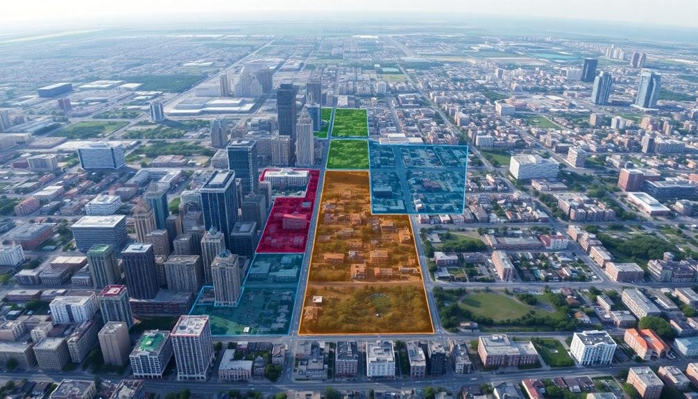
Digital surveys have revolutionized the way you can approach zoning and land use changes in your growing city. These tools provide real-time data on how residents and businesses utilize different areas, allowing you to make informed decisions about rezoning and development.
You'll gain insights into:
| Aspect | Benefits |
|---|---|
| Density | Identify areas for increased housing |
| Mixed-use | Spot opportunities for diverse development |
| Green spaces | Locate underserved neighborhoods |
| Commercial zones | Determine areas for business expansion |
By analyzing survey data, you can pinpoint where zoning changes are most needed. For example, you might discover that a residential area lacks essential services, prompting you to reflect on rezoning for mixed-use development. Or, you could find that certain industrial zones are underutilized, presenting an opportunity for conversion to residential or commercial use.
Digital surveys also help you gauge public opinion on proposed zoning changes. You can collect feedback from residents and stakeholders, ensuring that any modifications align with community needs and preferences. This data-driven approach enhances transparency and helps you make decisions that balance growth with quality of life considerations.
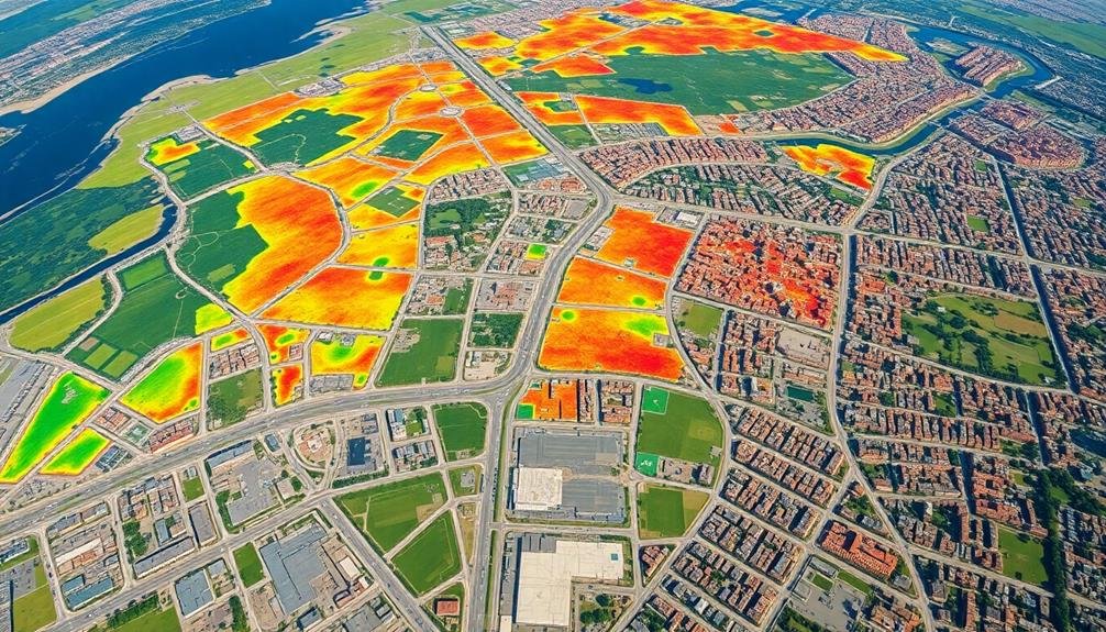
Urban Heat Island Detection
Another vital application of digital surveys in urban planning is urban heat island detection. You'll find that these surveys use remote sensing technologies to map temperature variations across urban areas. By analyzing thermal imagery, you can identify hotspots where buildings and pavement absorb and retain heat, causing higher temperatures than surrounding rural areas.
These digital surveys help you understand the impact of urban development on local climate. You'll be able to:
- Pinpoint areas with the highest heat retention
- Assess the effectiveness of green spaces in cooling neighborhoods
- Identify vulnerable populations at risk during heatwaves
- Evaluate the impact of different building materials on heat absorption
Armed with this information, you can make informed decisions about urban planning strategies.
You'll be able to implement targeted interventions, such as increasing tree cover, creating green roofs, or using reflective materials in construction. These measures can help mitigate the urban heat island effect, improving air quality and reducing energy consumption for cooling.
Frequently Asked Questions
How Accurate Are Digital Surveys Compared to Traditional Data Collection Methods?
You'll find digital surveys can be highly accurate, often matching or surpassing traditional methods. They're faster, reach broader audiences, and reduce human error. However, they may miss certain demographics, so it's best to use both approaches.
What Are the Privacy Concerns Associated With Conducting Digital Urban Surveys?
You should be aware of privacy concerns with digital urban surveys. They can collect sensitive data about your location, habits, and personal information. It's essential to guarantee proper data protection and anonymization measures are in place.
How Often Should Digital Surveys Be Updated for Optimal City Planning?
You should update digital surveys annually for ideal city planning. However, consider more frequent updates in rapidly changing areas. Don't forget to balance the frequency with cost and data processing capabilities. It's essential to maintain relevance.
Can Digital Surveys Predict Future Urban Growth Patterns?
You can use digital surveys to predict future urban growth patterns. They'll analyze current trends, population data, and development plans. By combining this information with AI and machine learning, you'll get valuable insights into potential expansion areas.
What Software or Tools Are Commonly Used for Analyzing Digital Survey Data?
You'll often use tools like SPSS, R, or Python for analyzing digital survey data. Excel and Tableau are great for visualization. Online platforms such as SurveyMonkey and Qualtrics offer built-in analysis features for their survey data.
In Summary
You've seen how digital surveys offer a wealth of insights into city growth. They're your window into urban sprawl, population shifts, and infrastructure development. You can track green spaces, analyze traffic patterns, and monitor zoning changes. Don't forget the power of detecting urban heat islands. With these tools, you're equipped to understand and plan for your city's future. Embrace digital surveys to make informed decisions and shape sustainable urban growth.
As educators and advocates for responsible drone use, we’re committed to sharing our knowledge and expertise with aspiring aerial photographers.


Leave a Reply