Aerial technologies are revolutionizing wildlife migration research. You'll find drones, satellites, and advanced tracking devices offering unprecedented views of animal movements across vast landscapes. These "eyes in the sky" capture high-resolution imagery and data, revealing intricate migration patterns and behaviors. Researchers can now track species over long distances, identifying essential habitats and monitoring population changes. Climate change impacts on migration are becoming clearer, with many species altering their routes and timing. While challenges exist, including ethical considerations and data analysis complexities, these airborne tools are transforming our understanding of wildlife dynamics. Exploring further will disclose the fascinating discoveries shaping modern conservation efforts.
Drone Technology in Wildlife Research
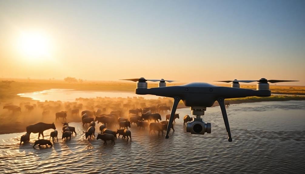
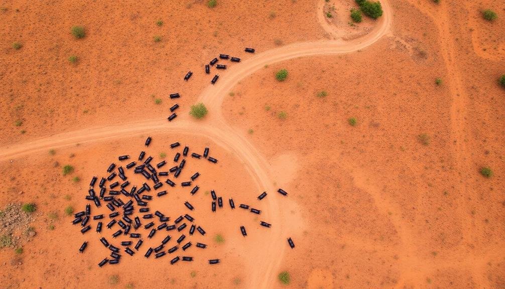
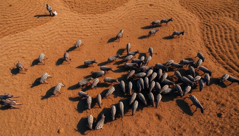
Drones have revolutionized wildlife research, offering unprecedented insights into animal migration patterns. You'll find these unmanned aerial vehicles equipped with high-resolution cameras and thermal imaging sensors, allowing researchers to track and monitor wildlife from above.
They're particularly useful for studying animals in hard-to-reach areas or those that are easily disturbed by human presence.
With drones, you can cover vast expanses of terrain quickly and efficiently, capturing detailed imagery of animal movements and behaviors. They've proven invaluable for counting populations, identifying new migration routes, and even detecting poaching activities.
You'll see researchers using drones to follow herds of elephants across African savannas, monitor sea turtle nesting sites along coastal areas, and track wolf packs in dense forests.
The data collected by drones is helping scientists better understand the complex dynamics of wildlife migration. You can now create detailed maps of animal movements, identify critical habitats, and assess the impact of environmental changes on migration patterns.
This technology is transforming our ability to protect endangered species and manage wildlife conservation efforts more effectively.
Aerial Tracking of Migratory Species
Aerial tracking of migratory species has advanced considerably beyond drone technology. You'll find that researchers now employ a variety of airborne tools to monitor wildlife movements across vast distances.
Satellites play a vital role, offering a bird's-eye view of entire migration routes. These orbiting eyes capture high-resolution imagery and collect data on environmental conditions that influence animal behavior.
Manned aircraft still have their place in aerial tracking. They're equipped with sophisticated cameras and sensors, allowing scientists to observe and document migrating herds, flocks, or individual animals in real-time. You'll see these planes following everything from monarch butterflies to wildebeest.
GPS collars and tags have revolutionized the field. When combined with aerial methods, they provide unprecedented insights into migration patterns. You can track an animal's exact location, speed, and altitude, creating detailed maps of their journeys.
Thermal imaging cameras mounted on aircraft help you spot animals at night or in dense vegetation. This technology's particularly useful for tracking nocturnal species or those in hard-to-reach areas.
Mapping Seasonal Animal Movements
You'll find satellite tracking technologies revolutionizing our understanding of seasonal migration patterns.
These advanced systems allow researchers to follow individual animals across vast distances, providing unprecedented insights into their movements.
Satellite Tracking Technologies
Numerous satellite tracking technologies have revolutionized our ability to map seasonal animal movements. You'll find that these innovations allow researchers to monitor wildlife across vast distances and challenging terrains. GPS collars, for instance, provide real-time location data for large mammals, while tiny tags track migratory birds' intercontinental journeys.
Here's a breakdown of popular satellite tracking technologies:
| Technology | Application |
|---|---|
| GPS Collars | Large mammals |
| Argos Tags | Marine animals |
| GSM Trackers | Birds, reptiles |
| ICARUS System | Small animals |
| Acoustic Telemetry | Fish, aquatic species |
You'll see that each technology offers unique advantages. GPS collars provide high-precision data but require larger batteries. Argos tags work well for marine animals, transmitting data when they surface. GSM trackers utilize cellular networks, making them cost-effective for tracking animals in populated areas. The ICARUS system, operated from the International Space Station, can track smaller animals globally. Acoustic telemetry is ideal for monitoring fish movements in rivers and oceans.
These technologies have dramatically improved our understanding of animal migration patterns, helping conservationists develop more effective protection strategies and manage wildlife populations more efficiently.
Seasonal Migration Patterns
Armed with these advanced tracking technologies, researchers have uncovered fascinating seasonal migration patterns across various species. You'll find that these patterns reveal the complex rhythms of animal movement driven by changing environmental conditions.
Birds, for instance, often travel thousands of miles between breeding and wintering grounds. You can observe how Arctic terns make an annual round-trip journey of over 40,000 miles from the Arctic to Antarctica.
Mammals like caribou migrate in large herds, covering distances up to 3,000 miles in search of food and calving grounds.
You'll notice that marine animals exhibit equally impressive migration patterns. Humpback whales travel from polar feeding areas to tropical breeding grounds, while sea turtles navigate vast ocean expanses to return to their natal beaches for nesting.
These seasonal movements aren't random. They're timed precisely with factors such as food availability, temperature changes, and daylight hours.
Challenges in Drone-Based Migration Studies

Drones have revolutionized wildlife migration studies, but they're not without their challenges. You'll find that using these unmanned aerial vehicles for tracking animal movements comes with a unique set of obstacles. Weather conditions can severely impact drone operations, limiting flight times and data collection opportunities.
You're also constrained by battery life, which restricts the duration of each flight and the distance covered.
When you're conducting drone-based migration studies, you'll need to take into account these additional challenges:
- Regulatory restrictions on drone usage in certain areas
- Potential disturbance to wildlife, affecting their natural behavior
- Limited payload capacity for sensors and equipment
- Data processing and storage requirements for large amounts of imagery
- Difficulty in tracking small or camouflaged animals
You'll need to develop strategies to overcome these hurdles. This might involve using multiple drones, implementing advanced image recognition software, or combining drone data with other tracking methods.
As you navigate these challenges, you'll find that drone technology continues to evolve, offering new solutions and capabilities for wildlife migration research.
Data Analysis From Aerial Imagery
With the advent of high-resolution aerial imagery, you're now faced with the task of processing and analyzing vast amounts of data. You'll need to employ sophisticated software and algorithms to extract meaningful information about wildlife migration patterns.
You'll start by preprocessing the images, adjusting for atmospheric conditions and georeferencing each frame. Then, you'll use machine learning techniques to identify and track individual animals across multiple frames. This process requires powerful computing resources and specialized expertise.
Once you've extracted the raw data, you'll need to interpret it in the context of migration patterns. Here's a breakdown of the key steps:
| Step | Description | Challenges | Tools |
|---|---|---|---|
| Image Preprocessing | Enhance image quality | Atmospheric distortion | Image processing software |
| Animal Detection | Identify individual animals | Similar species, camouflage | AI-based detection algorithms |
| Movement Tracking | Track animals across frames | Occlusion, frame rate | Optical flow algorithms |
| Pattern Analysis | Identify migration routes | Data noise, seasonal variations | Statistical analysis software |
Ethical Considerations in Drone Surveys
As you utilize advanced technology to track wildlife, it's important to contemplate the ethical implications of your methods. Drone surveys, while efficient and non-invasive, raise several concerns that you must address.
Consider these key ethical points:
- Animal stress: Drones can cause distress to wildlife, altering their behavior.
- Habitat disruption: Frequent flights may disturb nesting sites or feeding grounds.
- Privacy issues: Unintended capture of human activities in surveyed areas.
- Data security: Protecting sensitive information about endangered species.
- Resource allocation: Balancing technology costs with conservation benefits.
You'll need to weigh these factors against the valuable data you collect. Implement strict protocols to minimize disturbance, such as maintaining safe distances and limiting flight durations.
Ascertain you've obtained necessary permits and approvals from wildlife authorities.
Engage with local communities and stakeholders to address concerns and build trust. Be transparent about your research methods and goals.
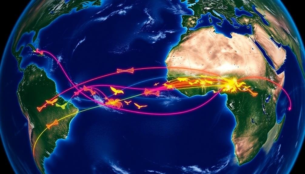
Species-Specific Migration Patterns Uncovered
You'll find that satellite tracking techniques have revolutionized our understanding of wildlife migration.
By analyzing vast amounts of movement data, scientists can now pinpoint precise routes and timing of animal journeys across continents and oceans.
These methods have uncovered surprising behavioral insights, such as how some species adapt their migration patterns in response to climate change or human disturbances.
Satellite Tracking Techniques
Satellite tracking has transformed our understanding of wildlife migration patterns. You'll find that researchers now use advanced GPS technology to monitor animals' movements with unprecedented accuracy. These devices, often fitted as collars or tags, transmit real-time location data to satellites orbiting Earth.
You're able to track various species, from tiny songbirds to massive whales, thanks to this technology. Here's what satellite tracking offers:
- Precise location data
- Long-term monitoring capabilities
- Insights into habitat use and preferences
- Information on migration routes and stopover sites
- Detection of changes in migration patterns due to climate change
You'll see that this method provides a wealth of information that was previously impossible to obtain. It's helping scientists map intricate migration routes, identify vital habitats, and understand the challenges animals face during their journeys.
You can now witness how different species navigate across continents and oceans, adapting to changing environments. This knowledge is essential for conservation efforts, allowing you to develop targeted strategies to protect migrating wildlife and their habitats.
Satellite tracking continues to disclose the mysteries of animal movement, offering a bird's-eye view of nature's grand migrations.
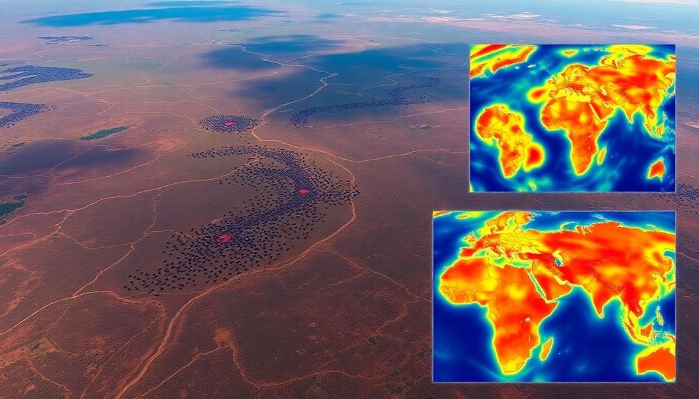
Data Analysis Methods
Mountains of data collected from satellite tracking devices require sophisticated analysis methods to uncover species-specific migration patterns. You'll find that researchers use various techniques to make sense of this information. They often start with data cleaning, removing anomalies and errors that could skew results.
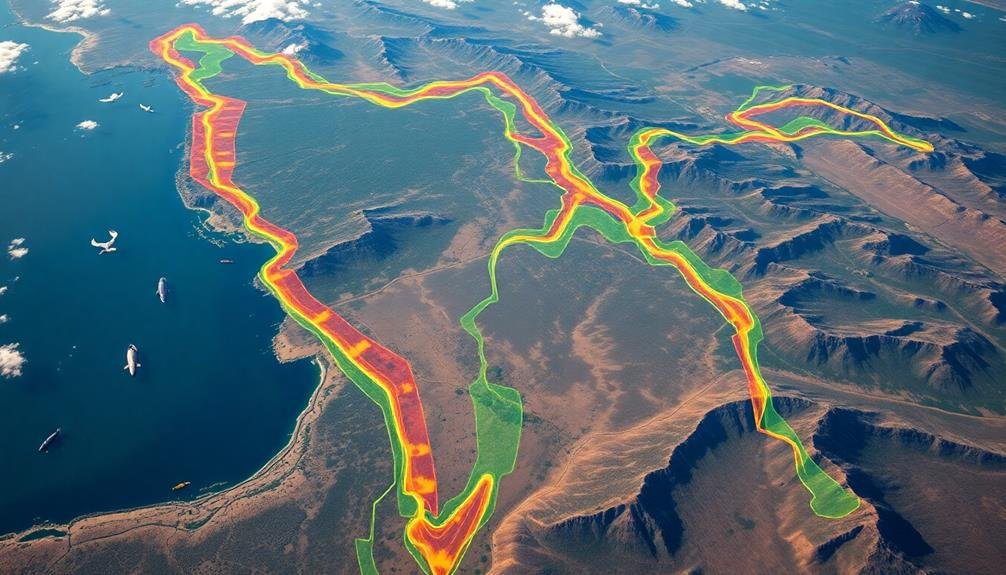
Next, they'll apply statistical models to identify trends and patterns in animal movements. You'll see that geographic information systems (GIS) play an essential role in visualizing and analyzing spatial data. These tools allow scientists to map migration routes, stopover sites, and habitat use.
Machine learning algorithms are increasingly used to detect complex patterns that mightn't be apparent through traditional methods. Time-series analysis helps you understand how migration patterns change over seasons and years.
Researchers also employ network analysis to examine connectivity between different habitats and populations. By comparing data across multiple species, you can uncover broader ecological patterns and interspecies interactions.
To guarantee accuracy, scientists often use cross-validation techniques and sensitivity analyses. They'll also incorporate environmental data, such as weather patterns and land-use changes, to contextualize animal movements and predict future migration trends.
Surprising Behavioral Insights
While researchers expected to uncover general migration patterns, the data revealed surprising species-specific behaviors that challenged previous assumptions.
You'll find that different species exhibit unique traits during their migrations, often defying conventional wisdom.
The satellite tracking has uncovered fascinating insights:
- Some birds take unexpected detours, adding thousands of miles to their journeys
- Certain mammal species use "staging areas" for extended periods before continuing migration
- Fish populations show precise timing in their movements, synced with ocean currents
- Insects demonstrate complex multi-generational migration patterns
- Some reptiles alter their routes based on yearly climate variations
You'll notice that these findings have significant implications for conservation efforts.
By understanding these specific behaviors, you can better protect vital habitats and migration corridors.
The data also reveals how climate change is impacting migration patterns, with some species altering their routes or timing in response to changing environmental conditions.
As you explore deeper into the results, you'll see that these insights aren't just academically interesting – they're essential for developing effective wildlife management strategies and predicting how species might adapt to future environmental changes.
Drone vs. Traditional Tracking Methods
The advent of drone technology has revolutionized wildlife tracking methods. You'll find that drones offer significant advantages over traditional tracking techniques. They provide a bird's-eye view of animal movements, covering vast areas quickly and efficiently. Unlike radio collars or GPS tags, drones don't require physically capturing animals, reducing stress and potential harm.
You can use drones to observe multiple species simultaneously, gathering data on entire ecosystems. They're particularly useful for tracking migratory patterns of birds, marine mammals, and large terrestrial animals.
However, traditional methods still have their place. Radio collars and GPS tags offer continuous, long-term data on individual animals, which drones can't match.
When you're deciding between drones and traditional methods, consider your research goals. Drones excel at population-level observations and habitat mapping, while traditional techniques provide detailed insights into individual behavior.
You'll often find the best results by combining both approaches. Drones can guide you to areas of interest, which you can then study more closely using traditional tracking methods. This hybrid approach maximizes the strengths of each technique, giving you a more thorough understanding of wildlife migration patterns.
Climate Change Impact on Migrations

Climate change is rapidly altering wildlife migration patterns across the globe.
You'll notice species struggling to adapt to new seasonal cues and changing habitats along their traditional routes.
These shifts pose significant challenges for animals, potentially disrupting their feeding, breeding, and survival strategies.
Shifting Migration Patterns
Over recent decades, global warming has considerably altered wildlife migration patterns. You'll notice these changes across various species and habitats. Birds are flying longer distances to reach suitable breeding grounds, while some mammals are shifting their ranges northward or to higher elevations. These shifts can have profound impacts on ecosystems and biodiversity.
As you observe these changing patterns, you'll see:
- Earlier spring migrations
- Delayed autumn returns
- Extended breeding seasons
- New stopover sites emerging
- Traditional routes being abandoned
You'll find that some species are adapting well to these changes, while others struggle to keep up. For example, you might observe Arctic terns flying even further north to find food, or monarch butterflies altering their routes to Mexico.
In some cases, you'll witness entire populations relocating to new areas altogether.
These shifting patterns aren't just academic curiosities; they're reshaping entire ecosystems. You'll see predator-prey relationships disrupted, plant pollination cycles altered, and new competitions for resources emerging.
As you study these changes, you're witnessing evolution in action, driven by human-induced climate change.
Species Adaptation Challenges
Adaptation hurdles pose significant challenges for migrating species in the face of climate change. You'll find that as temperatures rise and weather patterns shift, many animals struggle to adjust their long-established migration routes and timing.
These changes can lead to mismatches between species' arrival times and the availability of critical resources like food and nesting sites.
You'll notice that some species are better equipped to adapt than others. Birds, for instance, may alter their migration schedules more easily than large mammals. However, even for adaptable species, the pace of climate change often outstrips their ability to evolve new behaviors or physiological traits.
The consequences of failed adaptation can be severe. You'll see declining populations, increased competition for resources, and potential extinctions. Climate change also affects the habitats along migration routes, forcing animals to navigate unfamiliar landscapes or face new predators.
To help mitigate these challenges, you can support conservation efforts that focus on preserving and connecting diverse habitats. This approach gives migrating species the best chance to adapt and survive in a rapidly changing world.
Future of Airborne Wildlife Monitoring
Increasingly, airborne wildlife monitoring is poised to revolutionize our understanding of animal migrations. You'll see rapid advancements in technology that'll enable researchers to track more species across vast distances with unprecedented accuracy. Drones, satellites, and high-altitude balloons will become essential tools in wildlife conservation efforts.
These airborne monitoring systems will offer:
- Real-time data collection
- Reduced disturbance to animals
- Coverage of remote and inaccessible areas
- Cost-effective long-term monitoring
- Integration with AI for automated tracking
You can expect to see a shift towards non-invasive tracking methods, eliminating the need for physical tagging in many cases. This'll minimize stress on animals and provide more natural behavioral data.
As climate change continues to alter migration patterns, you'll witness the vital role of airborne monitoring in adapting conservation strategies.
You'll also see increased collaboration between researchers, governments, and tech companies to develop and implement these advanced monitoring systems. This partnership will lead to more thorough and standardized data collection, enabling better-informed conservation decisions.
The future of airborne wildlife monitoring is bright, and you'll be amazed at the insights it'll reveal about our planet's migratory species.
Frequently Asked Questions
How Do Drones Affect the Behavior of Animals During Migration?
You'll find that drones can disrupt animal migration. They may cause stress, alter flight paths, or scare animals away from vital rest stops. It's important to use drones responsibly to minimize their impact on wildlife behavior.
What Are the Legal Restrictions on Using Drones for Wildlife Research?
You'll need permits for drone use in wildlife research. You're required to follow local and federal regulations, maintain safe distances from animals, and avoid protected areas. You can't harass wildlife or interfere with their natural behaviors.
Can Drone Technology Help Predict and Prevent Human-Wildlife Conflicts?
You'll find drones incredibly useful for predicting and preventing human-wildlife conflicts. They can monitor animal movements, identify potential conflict zones, and alert authorities. This real-time data helps you take proactive measures to protect both wildlife and communities.
How Accurate Are Migration Maps Created Using Drone-Collected Data?
You'll find migration maps created with drone data are highly accurate. They're often more precise than traditional methods, capturing real-time movements and detailed patterns. However, accuracy can vary depending on factors like drone technology and data analysis techniques.
Are There Any Ongoing International Collaborations for Global Migration Mapping?
You'll find several ongoing international collaborations for global migration mapping. They're using satellite data, GPS tracking, and citizen science to create detailed maps. Projects like Movebank and ICARUS are at the forefront of these collaborative efforts.
In Summary
You've seen how drones are revolutionizing wildlife migration research. They're giving us unprecedented views of animal movements and helping map complex seasonal patterns. While challenges remain, you can't ignore the potential of this technology. It's outperforming traditional methods and revealing climate change impacts. As you look to the future, expect even more advanced airborne monitoring to disclose the secrets of wildlife migration, transforming our understanding of animal behavior and ecosystem dynamics.
As educators and advocates for responsible drone use, we’re committed to sharing our knowledge and expertise with aspiring aerial photographers.


Leave a Reply