
Modern drought evaluation relies heavily on "eyes in the sky" – advanced aerial and satellite technologies. You'll find drones equipped with sensors and cameras detecting early signs of water stress in crops. Satellites provide wide-scale vegetation health monitoring using specialized indices. These technologies also track water resources, analyzing reservoir levels and soil moisture. For agriculture, they're vital in evaluating crop health and predicting yields. To make sense of all this data, robust analysis and visualization techniques are employed. From drones to satellites, these aerial technologies are revolutionizing how we monitor and respond to drought conditions. Explore further to uncover the full potential of these high-tech drought detection methods.
Drones in Drought Detection
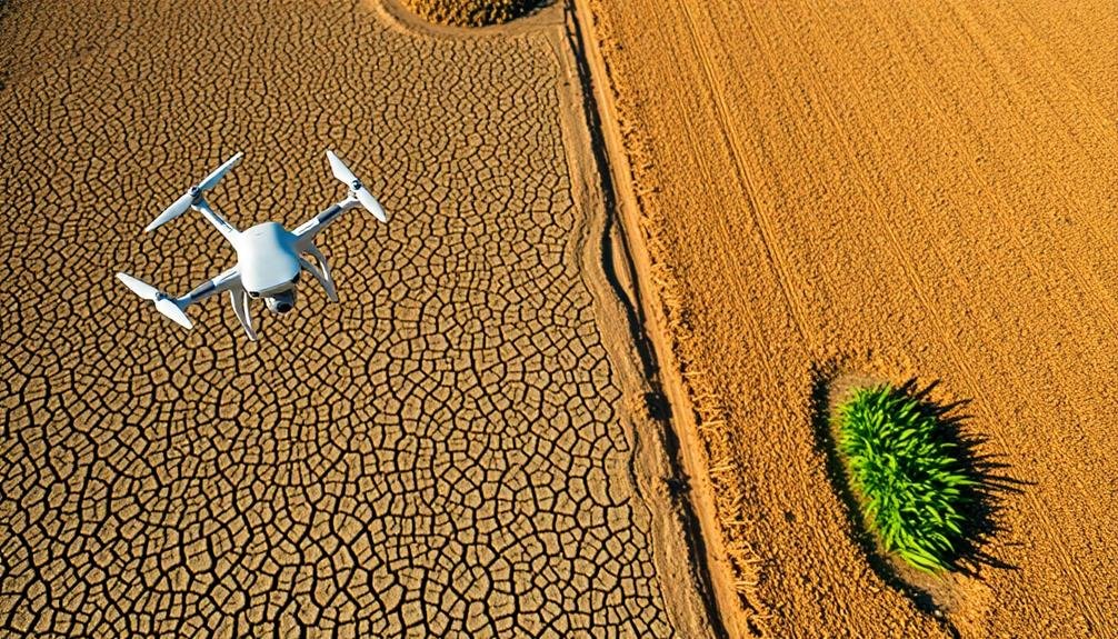
As drought conditions worsen globally, drones have emerged as a powerful tool for early detection and monitoring. You'll find these unmanned aerial vehicles equipped with advanced sensors and cameras, capable of capturing high-resolution images and data across vast agricultural areas.
Drones can quickly survey large expanses of land, identifying signs of water stress in crops and vegetation before they're visible to the naked eye.
You'll appreciate how drones use multispectral and thermal imaging to measure plant health and soil moisture levels. These technologies allow you to detect subtle changes in crop color, temperature, and water content, providing early warnings of drought stress.
With this information, you can make timely decisions about irrigation, crop management, and resource allocation.
Drones also offer cost-effective and efficient alternatives to traditional ground-based surveys. You'll save time and resources while gaining access to hard-to-reach areas.
Vegetation Health Monitoring
While drones provide valuable aerial data, vegetation health monitoring encompasses a broader range of techniques and technologies. You'll find that satellite imagery plays an essential role in this process, offering wide-scale coverage of plant conditions. These satellites use specialized sensors to measure vegetation indices, such as the Normalized Difference Vegetation Index (NDVI), which quantifies plant health based on chlorophyll content.
You can also employ ground-based sensors to complement aerial data. These devices measure soil moisture, temperature, and other environmental factors that influence plant growth. By integrating this information with satellite and drone imagery, you'll get an extensive view of vegetation health across large areas.
Advanced image processing algorithms help you analyze the collected data, detecting early signs of drought stress in plants. You'll notice changes in leaf color, canopy structure, and growth patterns that indicate water deficiency. This early detection allows for timely interventions, such as targeted irrigation or crop management adjustments.
You should also consider using hyperspectral imaging, which captures data across hundreds of spectral bands. This technology enables you to identify subtle changes in plant physiology, providing insights into drought impacts before visible symptoms appear.
Water Resource Management
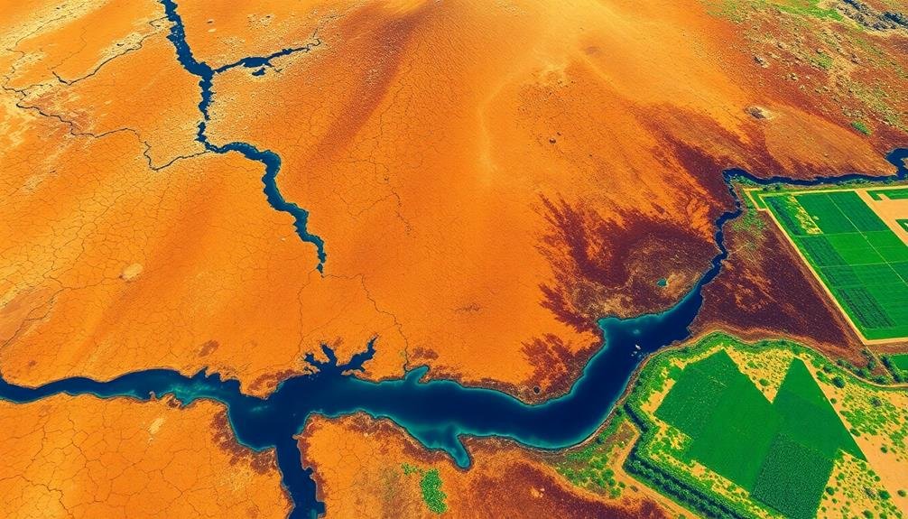
Water resource management is a vital component of drought effects assessment. When you're dealing with drought conditions, it's important to monitor and manage water resources efficiently.
You'll need to keep a close eye on reservoir levels, groundwater depletion, and river flows to make informed decisions about water allocation.
Satellite imagery and remote sensing technologies can help you track changes in water bodies over time. You'll be able to detect shrinking lakes, drying riverbeds, and diminishing snowpack. This information is significant for predicting water availability and planning conservation efforts.
You can also use these tools to assess soil moisture levels, which directly impact agricultural productivity and ecosystem health. By combining this data with weather forecasts and historical trends, you'll be better equipped to implement water-saving measures and prioritize resource distribution.
Don't forget to monitor water quality as well. Drought can concentrate pollutants and increase salinity, affecting both human and environmental health.
With thorough water resource management, you'll be able to mitigate drought impacts and develop more resilient water systems for the future.
Agricultural Impact Assessment
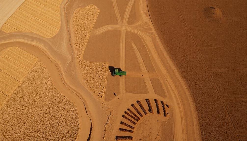
During drought periods, evaluating agricultural impacts becomes essential for understanding the broader economic and food security implications.
You'll need to assess crop health, yield predictions, and soil moisture levels to gauge the severity of drought effects on agriculture. Satellite imagery and remote sensing technologies are invaluable tools in this process, allowing you to monitor large areas efficiently.
You can use vegetation indices like NDVI (Normalized Difference Vegetation Index) to detect changes in crop vigor and health. These indices help you identify stressed vegetation before visible signs appear.
You'll also want to analyze soil moisture data from satellites or ground sensors to understand water availability for crops.
Crop yield models, combined with weather data and satellite observations, will help you forecast potential harvest reductions. You should compare these predictions with historical data to quantify the drought's impact.
Don't forget to assess irrigation water availability, as it directly affects crop production in drought-prone regions.
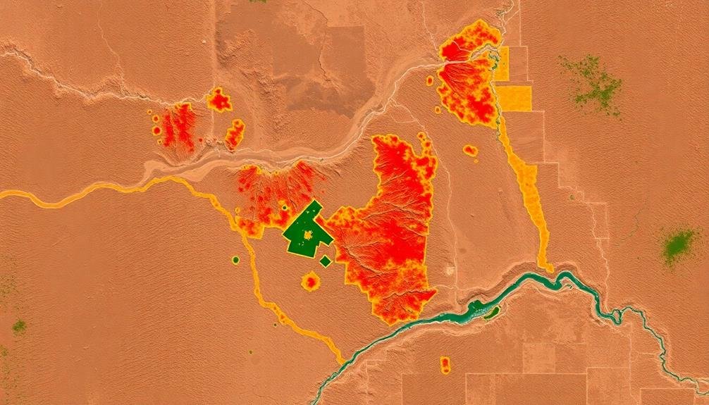
Data Analysis and Visualization

The vast amounts of data collected during drought assessments require robust analysis and visualization techniques to extract meaningful insights. You'll need to employ various statistical methods to process the information gathered from satellite imagery, ground sensors, and field surveys.
Start by cleaning and organizing your data, removing outliers and addressing any inconsistencies.
Next, you'll want to apply appropriate analytical tools, such as time series analysis, regression models, or machine learning algorithms, to identify patterns and trends in drought-related indicators. These may include changes in vegetation indices, soil moisture levels, or crop yields over time.
For visualization, you'll find that Geographic Information Systems (GIS) are invaluable. They allow you to create maps that display drought severity, affected areas, and temporal changes. You can also use interactive dashboards to present your findings, incorporating charts, graphs, and tables that highlight key metrics.
Don't forget to validate your results against historical data and expert knowledge. By combining rigorous analysis with clear, compelling visualizations, you'll provide decision-makers with the information they need to develop effective drought management strategies.
Frequently Asked Questions
How Do Satellites Contribute to Drought Detection and Monitoring?
You can rely on satellites to detect and monitor droughts effectively. They'll capture images and data on vegetation health, soil moisture, and temperature changes. This information helps you track drought conditions and their progression over time.
What Are the Limitations of Using Remote Sensing for Drought Assessment?
You'll find that remote sensing has limitations in drought assessment. It can't always detect soil moisture beneath vegetation, may struggle with cloud cover, and can't fully capture local conditions. You'll need ground-based data for a complete picture.
How Does Climate Change Affect the Accuracy of Drought Detection Technologies?
Climate change alters traditional patterns, making it harder for you to accurately detect droughts. You'll find that historical baselines become less reliable, and you'll need to constantly update your models to account for shifting climate norms.
Can Drought Detection Technologies Predict Future Water Shortages?
You'll find that drought detection technologies can predict future water shortages. They analyze current conditions, historical data, and climate trends to forecast potential scarcity. However, they're not infallible, so you should consider them alongside other factors.
What Role Does Artificial Intelligence Play in Improving Drought Assessment Methods?
You'll find AI's playing an essential role in drought assessment. It's improving prediction accuracy, analyzing vast datasets, and automating pattern recognition. You're seeing AI enhance early warning systems and optimize water resource management strategies more efficiently than ever before.
In Summary
You've seen how drones revolutionize drought assessment. They're your eyes in the sky, providing essential data on vegetation health, water resources, and agricultural impacts. You're now equipped to monitor vast areas efficiently, spotting early warning signs of drought stress. With advanced data analysis and visualization tools at your fingertips, you'll make informed decisions to mitigate drought effects. Embrace this technology, and you'll be better prepared to face future climate challenges head-on.
As educators and advocates for responsible drone use, we’re committed to sharing our knowledge and expertise with aspiring aerial photographers.


Leave a Reply