Drone views offer a breathtaking new perspective on famous landmarks you thought you knew. From above, you'll see the Eiffel Tower's perfect symmetry, the Great Wall snaking through mountains, and Machu Picchu's hidden secrets. The Taj Mahal's garden paradise and the Colosseum's ancient grandeur are revealed in stunning detail. You'll discover Petra's rose-red city emerging from the desert, Angkor Wat's sprawling temple complex, and Christ the Redeemer's heavenly vista over Rio. Santorini's white-washed villages perched on volcanic cliffs complete this aerial tour. These jaw-dropping views will change how you see these iconic sites forever.
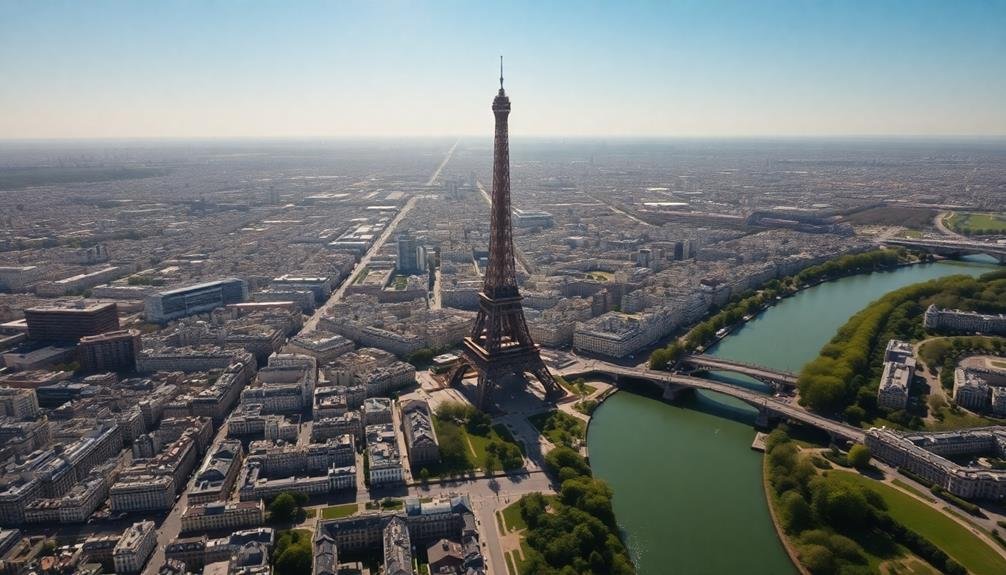
Eiffel Tower's Geometric Splendor
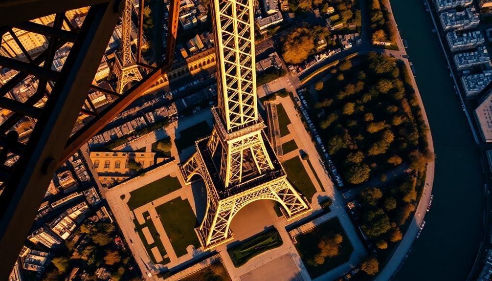
A marvel of engineering, the Eiffel Tower reveals its true geometric beauty when viewed from above. As you gaze down on this iconic Parisian landmark, you'll be struck by its perfect symmetry and intricate lattice structure. The tower's four legs form a graceful X-shape, converging at the central spire that pierces the sky.
From this bird's-eye perspective, you'll notice the tower's three distinct levels, each platform smaller than the one below. The first level appears as a wide square, while the second narrows considerably. The third and final observation deck forms a tight circle just below the pinnacle.
What's most enchanting is the iron latticework that makes up the tower's skeleton. It creates a mesmerizing pattern of triangles and diamonds, showcasing Gustave Eiffel's brilliant design. The negative space between the iron beams is equally striking, allowing you to see glimpses of Paris below.
As you take in this aerial view, you'll gain a new appreciation for the tower's scale and complexity. It's a tribute to human ingenuity and a stunning example of 19th-century architectural prowess that continues to inspire awe from every angle.
Great Wall Snaking Through Mountains
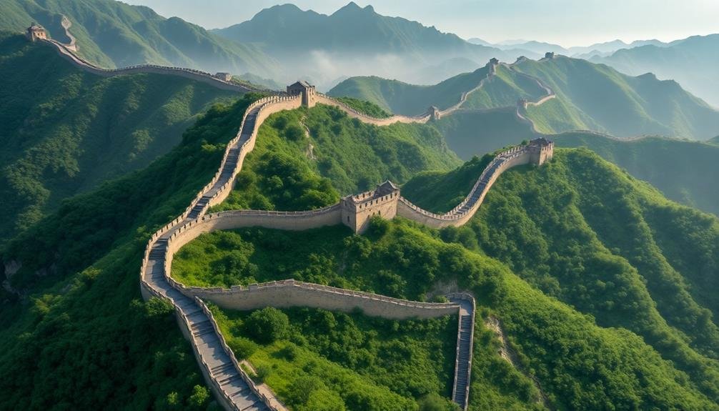
From above, you'll witness the Great Wall of China's undulating serpentine structure as it weaves through rugged mountain landscapes.
This aerial perspective reveals the wall's true scale and its remarkable ability to conform to diverse terrains.
You'll be struck by the architectural marvel that stretches for thousands of miles, showcasing ancient engineering prowess visible even from space.
Undulating Serpentine Structure
China's most iconic landmark takes on a mesmerizing form when viewed from above. As you gaze down at the Great Wall, you'll see an undulating serpentine structure that weaves its way through the rugged landscape. The wall's ancient stone segments twist and turn, following the contours of mountain ridges and valleys with remarkable precision.
From this aerial perspective, you'll notice how the wall seems to come alive, resembling a giant dragon's spine stretching across the terrain. Its meandering path creates a stark contrast against the lush green forests and barren rocky outcrops it traverses.
You'll be struck by the wall's ability to adapt to the challenging topography, showcasing the ingenuity of its ancient builders. As your view spans miles of this architectural marvel, you'll observe watchtowers dotting the wall's length at regular intervals.
These fortifications stand as sentinels, breaking up the sinuous line of the main structure. The aerial vantage point reveals the true scale and complexity of this UNESCO World Heritage site, offering a unique appreciation for one of humanity's greatest engineering feats.
Aerial Architectural Marvel
Soaring high above the Chinese landscape, you'll witness an architectural marvel like no other. The Great Wall of China snakes through the mountains, a tribute to human ingenuity and perseverance. From your aerial vantage point, you'll see how this ancient structure hugs the contours of the land, winding its way across rugged terrain for thousands of miles.
As you fly along the wall's path, you'll notice its varying states of preservation. Some sections stand proud and restored, while others have crumbled over time, reclaimed by nature. The contrast between the wall's rigid lines and the organic shapes of the surrounding landscape creates a mesmerizing visual spectacle.
| Feature | Description | Aerial View Highlight |
|---|---|---|
| Length | 13,171 miles | Endless serpentine structure |
| Construction | Stone, brick, rammed earth | Varied textures and colors |
| Terrain | Mountains, deserts, grasslands | Dramatic landscape contrasts |
From above, you'll appreciate the true scale of this monumental feat of engineering. The Great Wall's watchtowers dot the landscape like sentinels, offering a glimpse into its defensive purpose. As you observe this wonder from the sky, you'll gain a new perspective on its historical significance and enduring impact on the world.
Machu Picchu's Hidden Inca Secrets
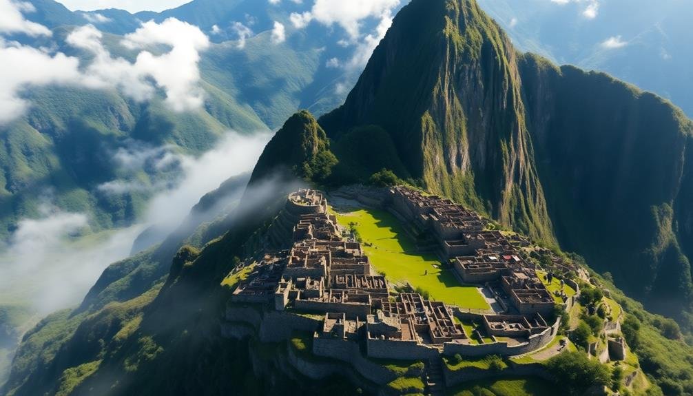
Ancient wonders reveal themselves from above, and Machu Picchu is no exception. As you gaze down on this Incan citadel from a drone's perspective, you'll spot hidden details that aren't visible from the ground. The intricate network of terraces becomes more apparent, showcasing the Incas' advanced agricultural techniques and their ability to cultivate crops on steep mountain slopes.
From this vantage point, you'll notice the precise alignment of buildings with celestial events, hinting at the Incas' sophisticated astronomical knowledge. The city's layout reveals itself as a condor-shaped design, a symbol of spiritual significance in Inca culture.
You'll also spot the remnants of the Inca Trail, winding its way through the mountains to connect Machu Picchu with other important sites. The aerial view highlights the site's strategic location, nestled between sacred peaks and protected by steep cliffs.
You'll see how the Urubamba River encircles the citadel, forming a natural barrier. This bird's-eye perspective also reveals previously undiscovered structures and pathways, shedding new light on the extent and complexity of this ancient marvel.
Taj Mahal's Symmetrical Garden Paradise
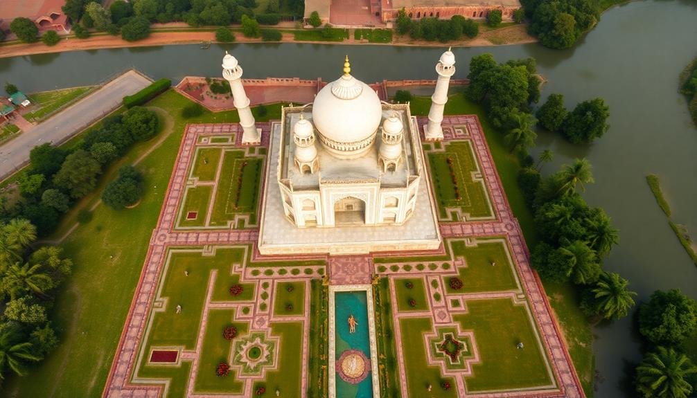
From high above, the Taj Mahal reveals its true splendor as a masterpiece of symmetry and design. You'll be struck by the perfect alignment of the mausoleum, its four minarets, and the surrounding gardens.
The aerial view showcases the Char Bagh layout, a quadrilateral Persian garden style divided into four equal parts by waterways. As you gaze down, you'll notice the intricate geometric patterns that extend from the main structure into the lush gardens.
The central water channel reflects the Taj's iconic dome, creating a mesmerizing mirror effect. You can spot the red sandstone mosque and its twin building, maintaining perfect balance on either side of the mausoleum.
From this vantage point, you'll appreciate how the entire complex is oriented towards Mecca, with the tomb slightly off-center. The aerial perspective also highlights the contrast between the white marble of the Taj and the vibrant green of the surrounding gardens.
You'll see how the pathways and flowerbeds create a harmonious blend of nature and architecture, emphasizing the paradise-like quality of this UNESCO World Heritage site.
Colosseum's Ancient Roman Grandeur
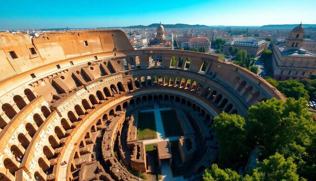
From above, you'll witness the Colosseum's true architectural grandeur in a way that's impossible from ground level.
The aerial view showcases the impressive scale and intricate design of this ancient Roman amphitheater, revealing its elliptical shape and complex network of underground chambers.
You'll gain a unique perspective on the historical significance of this iconic structure, seeing how it dominated the Roman landscape and served as a centerpiece for entertainment and social gatherings.
Aerial Perspective Reveals History
Soaring high above Rome's iconic Colosseum, you'll witness a breathtaking aerial view that reveals the ancient amphitheater's true grandeur.
From this vantage point, you can clearly see the oval shape and massive scale of the structure, which once hosted gladiatorial contests and public spectacles for up to 80,000 spectators.
As you gaze down, you'll notice the intricate network of underground chambers and passages beneath the arena floor.
These subterranean areas, known as the hypogeum, were once used to house animals, stage equipment, and gladiators before their dramatic entrances into the arena.
The aerial perspective also highlights the Colosseum's architectural ingenuity.
You'll observe the remnants of the complex system of arches and vaults that supported the structure, as well as the clever design that allowed for efficient crowd management and rapid evacuation.
From above, you can appreciate how the Colosseum's design influenced countless modern stadiums and arenas.
Its elliptical shape, tiered seating, and multiple entrances set the standard for large-scale entertainment venues that continues to this day.
Architectural Majesty From Above
As you gaze down upon the Colosseum, you'll be struck by its architectural majesty. The iconic elliptical shape becomes even more apparent from above, revealing the perfect symmetry of its design.
You'll notice the intricate network of arches and corridors that form the skeleton of this ancient amphitheater, a demonstration of Roman engineering prowess.
From this aerial perspective, you can appreciate the sheer scale of the Colosseum. Its massive footprint dwarfs the surrounding structures, emphasizing its historical importance.
You'll spot the remnants of the hypogeum, the complex underground system of tunnels and chambers that once housed gladiators and wild animals.
The bird's-eye view allows you to see how the Colosseum fits into the broader landscape of Rome. You'll observe how it aligns with nearby ancient ruins, creating a visual timeline of the city's rich history.
The contrast between the weathered stone of the Colosseum and the modern urban fabric surrounding it is particularly striking from above, highlighting the enduring legacy of this architectural marvel in the heart of Rome.
Statue of Liberty's Torch View
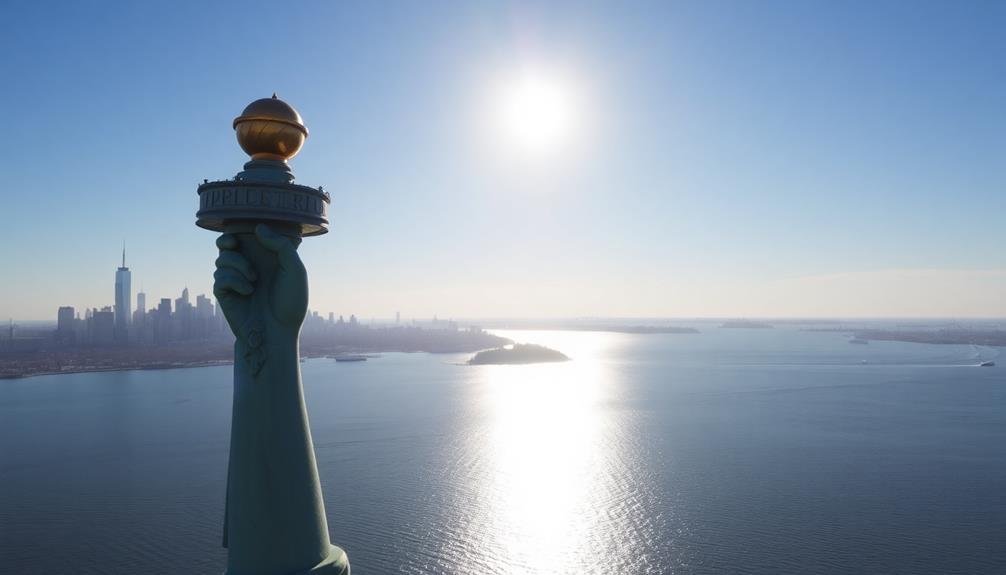
The Statue of Liberty's torch offers a rare and breathtaking aerial perspective of New York Harbor. From this vantage point, you'll see the city's iconic skyline and bustling waterways in a whole new light. The torch, which stands at 305 feet above ground level, provides a 360-degree view that's simply unmatched.
As you gaze out from Lady Liberty's torch, you'll notice:
| Direction | View |
|---|---|
| North | Manhattan's skyscrapers |
| East | Brooklyn Bridge and East River |
| South | Staten Island and Atlantic Ocean |
| West | New Jersey and Hudson River |
The torch's panoramic view showcases the stark contrast between the urban landscape and the surrounding waters. You'll spot ferries crisscrossing the harbor, cargo ships entering port, and pleasure boats dotting the waterways. On a clear day, you can even see as far as the Verrazano-Narrows Bridge to the south and the George Washington Bridge to the north.
This unique perspective not only offers stunning visuals but also provides a deeper appreciation for the statue's strategic placement and its role as a welcoming beacon for generations of immigrants.
Petra's Rose-Red City Unveiled
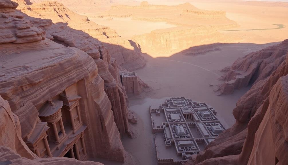
From above, you'll witness Petra's hidden city emerge from the desert landscape, its rose-red structures stark against the surrounding terrain.
You'll marvel at the intricate architectural patterns that become visible, revealing the city's complex layout and design.
As you gaze down, you'll gain a new appreciation for the ancient Nabataeans' engineering prowess and urban planning skills, which are fully exposed from this aerial vantage point.
Hidden City Revealed Above
Countless visitors have marveled at Petra's ancient rock-cut architecture from ground level, but few have seen its full splendor from above. When you view Petra from the sky, you'll witness the true scale and complexity of this hidden city carved into the red rock canyons of southern Jordan.
From this aerial perspective, you'll notice the intricate network of water conduits and dams that once sustained the Nabataean capital. You'll see how the city's layout follows the natural contours of the landscape, with structures seamlessly integrated into the mountainsides.
The famous Treasury, Petra's most iconic building, appears as a small jewel nestled within the vast expanse of rock formations.
You'll also spot lesser-known structures that aren't visible from ground level, such as the expansive Great Temple complex and the remnants of gardens and agricultural terraces. The aerial view reveals the city's strategic positioning, surrounded by steep cliffs that provided natural defense.
As you take in this bird's-eye view, you'll gain a deeper appreciation for the ingenuity and architectural prowess of the ancient Nabataeans who created this remarkable hidden city.
Intricate Architectural Patterns Exposed
Viewed from above, Petra's intricate architectural patterns come to life in stunning detail. You'll witness the ancient Nabataean city's layout, carved into the rose-red cliffs of southern Jordan. From this vantage point, you can see how the city's designers masterfully integrated their structures with the natural landscape.
The aerial perspective reveals the complex network of water conduits and cisterns that made life possible in this arid region. You'll notice the precision of the rock-cut facades, their symmetry more apparent from above. The famous Treasury, Al-Khazneh, stands out with its elaborate Hellenistic design, its columns and pediments forming a striking contrast against the rugged terrain.
As you scan the landscape, you'll spot the vast necropolis, with hundreds of tombs dotting the cliffs. The Roman-style theater, carved into the hillside, becomes more impressive when viewed in its entirety.
The colonnaded street, once bustling with traders, stretches out before you, its straight lines a demonstration of ancient urban planning. This bird's-eye view of Petra exposes the ingenuity and architectural prowess of its creators, offering a new appreciation for this UNESCO World Heritage site.
Angkor Wat's Jungle-Shrouded Temples
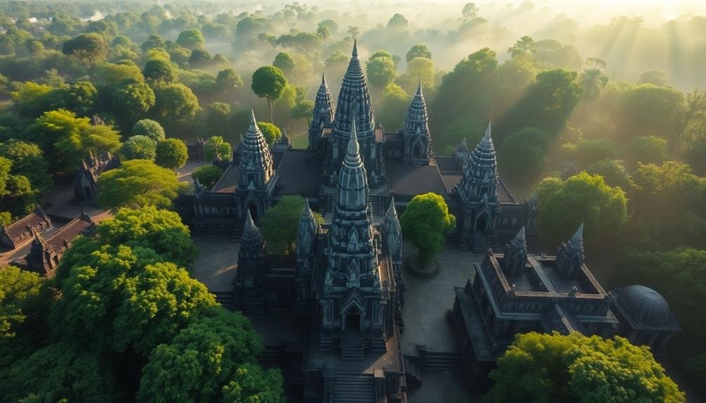
As you gaze down upon the sprawling complex of Angkor Wat, you'll witness a breathtaking fusion of ancient architecture and lush jungle. The aerial view reveals the true scale of this 12th-century marvel, with its iconic five towers rising above the surrounding greenery.
You'll notice the perfect symmetry of the temple's layout, designed to represent Mount Meru, the mythical home of Hindu gods.
From above, you can clearly see:
- The intricate network of moats and reservoirs surrounding the temple
- The vast courtyards and galleries connecting various structures
- The encroaching jungle, slowly reclaiming parts of the complex
As your drone hovers higher, you'll spot the lesser-known temples scattered throughout the area. The Ta Prohm temple stands out, its stone walls intertwined with massive tree roots.
The aerial perspective showcases the ongoing battle between nature and human creation, with centuries-old stone structures peeking through the dense canopy.
You'll also observe the precise alignment of Angkor Wat's main axis, pointing directly east. This orientation, visible only from above, highlights the advanced astronomical knowledge of the ancient Khmer civilization.
Christ the Redeemer's Heavenly Perspective
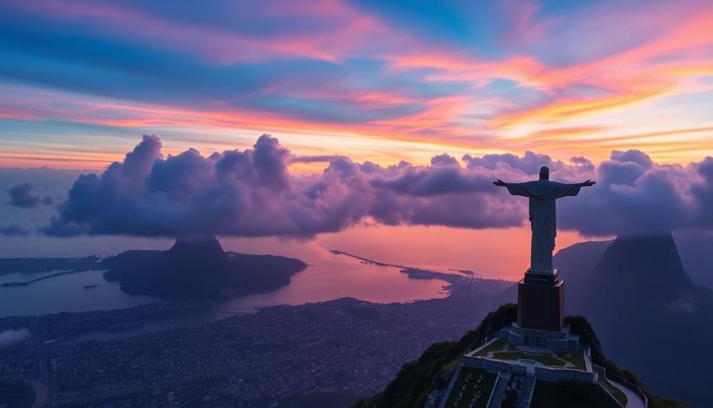
From the ancient temples of Cambodia, we shift our gaze to the iconic Cristo Redentor in Rio de Janeiro, Brazil. As you soar above this colossal Art Deco statue, you'll witness a breathtaking aerial perspective that few get to experience.
The 98-foot-tall Christ the Redeemer stands atop Corcovado Mountain, its outstretched arms spanning 92 feet. From above, you'll notice how the statue's geometric lines contrast sharply with the lush green slopes of Tijuca National Park below.
The aerial view reveals the statue's intricate mosaic tilework, which isn't easily visible from the ground. You'll also spot the winding road that leads pilgrims and tourists up the mountain.
As your drone circles higher, you'll see how Christ the Redeemer dominates the cityscape. The statue appears to watch over Rio's famous beaches, Sugarloaf Mountain, and the sprawling metropolis beyond.
This heavenly vantage point offers a unique appreciation of the statue's scale and its strategic placement. It's a reflection of human engineering and artistry, seamlessly blending with the natural beauty of Rio de Janeiro's dramatic landscape.
Santorini's White-Washed Cliffside Villages
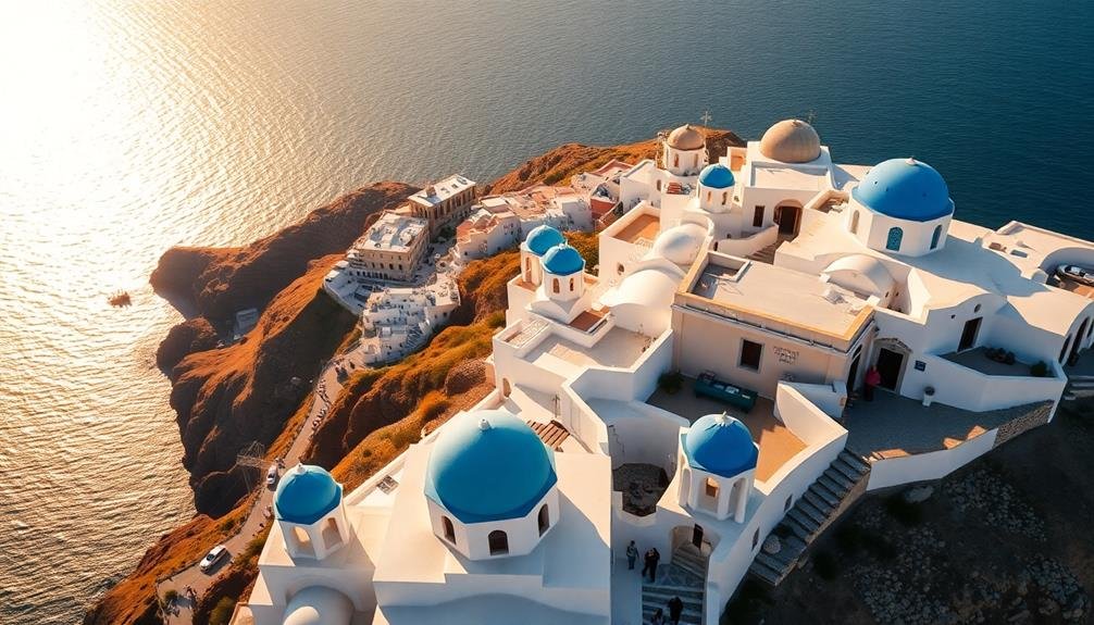
Our aerial journey takes us to the stunning Greek island of Santorini. From above, you'll witness the iconic white-washed villages perched precariously on the volcanic caldera's edge. The aerial view reveals a mesmerizing contrast between the azure Aegean Sea and the island's rugged terrain.
As your drone hovers over the cliffside towns of Oia and Fira, you'll notice:
- The intricate maze of narrow streets and staircases winding through the villages
- Blue-domed churches dotting the landscape, their vivid hues popping against the white buildings
- Infinity pools seemingly merging with the sea, creating a seamless blend of man-made luxury and natural beauty
The bird's-eye perspective showcases Santorini's unique crescent shape, formed by a catastrophic volcanic eruption thousands of years ago.
You'll spot the islands of Nea Kameni and Palea Kameni in the center of the caldera, remnants of more recent volcanic activity.
As the sun sets, the villages come alive with a warm glow, their lights twinkling against the darkening sky.
This aerial view of Santorini offers a breathtaking new appreciation for the island's geological wonders and architectural marvels.
Frequently Asked Questions
Are Drones Allowed Near These Landmarks for Personal Photography?
You'll find drone regulations vary by landmark. Many restrict or prohibit personal drone use for safety and privacy reasons. Always check local laws and obtain necessary permits before flying near famous sites to avoid fines or legal issues.
What's the Best Time of Day to Capture Aerial Views?
You'll get the best aerial views during the "golden hour" – just after sunrise or before sunset. It's when you'll capture warm, soft light and long shadows. Don't forget to check weather conditions for ideal visibility.
How High Can Drones Legally Fly to Capture These Landmarks?
You'll need to follow local regulations when flying drones near landmarks. In the US, you're generally limited to 400 feet above ground level. Always check specific rules for your location before launching your drone.
Which Drone Models Are Recommended for Photographing Famous Landmarks?
You'll want to contemplate DJI's Mavic 3 or Air 2S for stunning landmark shots. They offer excellent image quality and flight performance. For budget options, look at the Mini 3 Pro or Autel EVO Lite+. Always check local regulations before flying.
Are There Any Lesser-Known Landmarks That Offer Stunning Aerial Views?
You'll find plenty of hidden gems for aerial photography. Check out Zhangjiajie Glass Bridge in China, Socotra Island in Yemen, or the Chocolate Hills in the Philippines. Don't forget local spots in your area too!
In Summary
You've soared above some of the world's most iconic landmarks, seeing them in ways few ever will. From ancient wonders to modern marvels, these aerial views offer a fresh perspective on humanity's greatest achievements. They're a reflection of our ingenuity, artistry, and perseverance. Next time you're traveling, consider booking a drone tour or seeking out elevated viewpoints. You'll gain a newfound appreciation for these incredible sites and the stories they tell from above.
As educators and advocates for responsible drone use, we’re committed to sharing our knowledge and expertise with aspiring aerial photographers.


Leave a Reply