
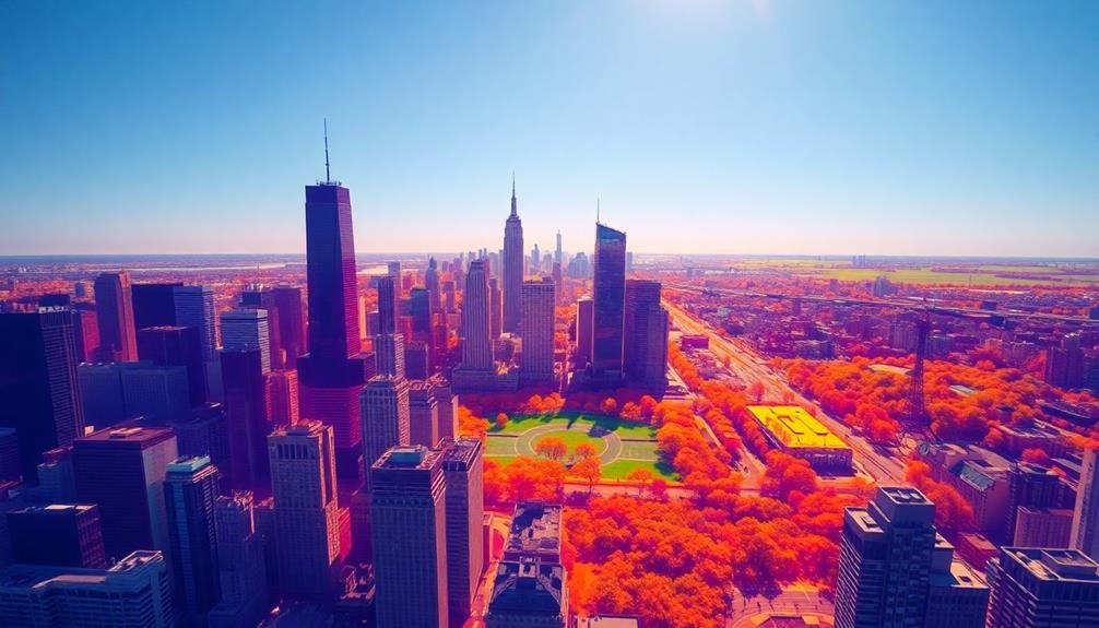
Urban heat islands are being mapped with unprecedented precision using sky-high microclimate studies. You'll find drones equipped with thermal cameras capturing detailed temperature data across cities, revealing hotspots and cool zones. These aerial surveys, combined with ground-level sensors, provide an extensive view of urban heat distribution. Thermal imaging technology allows researchers to visualize temperature variations invisible to the naked eye, identifying areas where heat-absorbing surfaces and building density contribute to elevated temperatures. This data informs urban planners and policymakers, guiding strategies to mitigate heat island effects through green infrastructure and innovative cooling solutions. Exploring these cutting-edge methods reveals the future of climate-resilient city design.
Urban Heat Island Phenomenon
In light of rapid urbanization, the urban heat island phenomenon has become a pressing concern for cities worldwide. You'll notice that urban areas are notably warmer than their rural surroundings, often by several degrees. This temperature difference is caused by various factors inherent to city environments.
As you walk through a city, you're surrounded by heat-absorbing surfaces like asphalt, concrete, and dark rooftops. These materials trap and retain heat, releasing it slowly throughout the day and night.
You'll also find that tall buildings create urban canyons, trapping hot air and reducing natural ventilation. Human activities contribute to this effect as well. You're constantly exposed to heat from vehicles, air conditioning units, and industrial processes.
The lack of vegetation in cities further exacerbates the problem, as there's less natural cooling through evapotranspiration.
The urban heat island effect has noteworthy consequences. You'll experience increased energy consumption for cooling, poorer air quality, and heightened health risks, especially during heatwaves.
It's essential to understand and address this phenomenon to create more sustainable and livable urban environments.
Drone Technology in Climate Research

As climate research evolves, drone technology has emerged as a powerful tool for studying urban heat islands. You'll find that drones equipped with thermal cameras and sensors can capture detailed temperature data across large urban areas quickly and efficiently.
They're able to fly at various altitudes, providing a thorough view of heat distribution patterns that ground-based measurements can't match.
You can use drones to create high-resolution thermal maps, revealing hotspots and cool zones within cities. These maps help you identify areas most affected by the urban heat island effect and guide targeted mitigation strategies.
Drones also allow you to monitor changes over time, tracking the effectiveness of interventions like green roofs or reflective surfaces.
You'll appreciate how drones can access hard-to-reach areas, such as rooftops and industrial zones, giving you a complete picture of urban microclimates.
They're particularly useful for studying temperature variations at different times of day and seasons. By combining drone data with other climate information, you'll gain deeper insights into urban heat dynamics, helping you develop more effective strategies to combat rising temperatures in cities.
Thermal Imaging Fundamentals

Thermal imaging is essential for understanding urban heat islands, relying on infrared radiation detection to capture temperature variations across city landscapes.
You'll find that the precision of temperature measurements depends on the quality of the imaging equipment and environmental conditions.
When conducting thermal imaging studies, you must consider spatial resolution to guarantee you're capturing detailed temperature data at the appropriate scale for your urban heat island analysis.
Infrared Radiation Detection
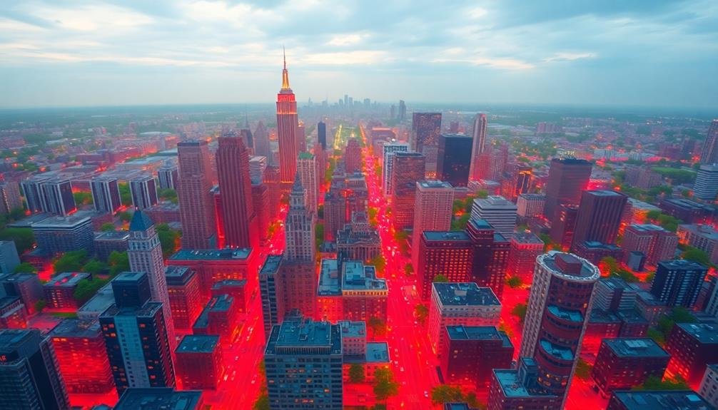
Infrared radiation detection forms the backbone of thermal imaging technology used in urban heat island studies. It allows you to visualize heat signatures that aren't visible to the naked eye. The process relies on sensors that capture the infrared energy emitted by objects and surfaces.
When you're conducting urban heat island research, you'll use specialized cameras equipped with these sensors. They detect wavelengths in the infrared spectrum, typically between 9 and 14 micrometers. This range is ideal for measuring surface temperatures in urban environments.
The sensors convert the detected infrared radiation into electrical signals. These signals are then processed to create a thermal image, where different colors represent varying temperature levels. You'll often see warmer areas displayed in reds and yellows, while cooler regions appear in blues and greens.
It's essential to understand that infrared radiation detection doesn't measure air temperature directly. Instead, it captures the surface temperatures of objects and materials. This distinction is important when interpreting thermal images for urban heat island analysis, as surface temperatures can differ markedly from ambient air temperatures.
Temperature Measurement Precision
With thermal imaging, temperature measurement precision is essential for accurate urban heat island studies. You'll need to reflect on several factors to guarantee your measurements are as precise as possible.
First, calibrate your thermal camera regularly using a blackbody source to maintain accuracy. Pay attention to the camera's thermal sensitivity, often expressed as Noise Equivalent Temperature Difference (NETD), which should be as low as possible for better precision.
When capturing thermal images, you'll want to take into account emissivity variations across different urban surfaces. Use emissivity tables or conduct on-site measurements to adjust your camera settings accordingly.
Be aware of atmospheric conditions, as humidity and air temperature can affect thermal readings. Contemplate using atmospheric correction software to compensate for these factors.
You should also be mindful of the spatial resolution of your thermal camera. Higher resolution allows for more detailed temperature mapping, especially when studying complex urban environments.
Don't forget to record metadata such as time, date, and weather conditions alongside your thermal images. This information will help you interpret temperature variations accurately and compare data across different time periods or locations.
Spatial Resolution Considerations
When conducting urban heat island studies, spatial resolution plays an essential role in thermal imaging. You'll need to evaluate the level of detail required for your analysis. Higher spatial resolution allows you to capture finer temperature variations across urban landscapes, but it comes at the cost of increased data processing and storage requirements.
You should choose your spatial resolution based on the scale of your study area and the specific features you're interested in. For city-wide assessments, a resolution of 30-100 meters might suffice, while neighborhood-level studies may require 1-5 meter resolution.
Remember that higher resolution doesn't always mean better results; it depends on your research objectives.
You'll also need to account for the trade-off between spatial and temporal resolution. If you're using satellite imagery, higher spatial resolution often means less frequent data collection. For ground-based or aerial surveys, you'll have more flexibility but may face logistical challenges.
Evaluate using multi-scale approaches, combining high-resolution data for specific areas of interest with lower-resolution data for broader context. This strategy can help you balance detail and coverage in your urban heat island mapping efforts.
Data Collection Methodologies

For urban heat island studies, researchers employ various data collection methodologies to accurately measure and analyze temperature variations across cities. You'll find that these methods range from ground-based sensors to satellite imagery and mobile measurements.
Ground-based weather stations are a common approach, providing continuous temperature data at fixed locations. You can supplement these with mobile transects, where you'll drive or walk through the city with temperature sensors, capturing spatial variations.
Thermal remote sensing is another powerful tool you'll use, utilizing satellite or aircraft-mounted sensors to detect surface temperatures across large areas. You might also deploy networks of low-cost sensors throughout the city, giving you a more detailed picture of microclimates.
Crowdsourced data from weather apps and personal weather stations can add to your dataset. For a thorough understanding, you'll often combine these methods, integrating ground-level measurements with aerial data.
When collecting data, you'll need to take into account factors like time of day, season, and weather conditions to guarantee consistent and comparable results. By using these diverse methodologies, you'll be able to create accurate and detailed urban heat island maps.
Mapping Temperature Variations

Mapping temperature variations is the next logical step after collecting data from various sources. You'll need to visualize the collected data to identify patterns and hotspots within urban areas.
Modern mapping techniques utilize Geographic Information Systems (GIS) to create detailed heat maps, allowing you to overlay temperature data with other urban features like building density, green spaces, and road networks.
When mapping urban heat islands, you'll typically use color gradients to represent temperature differences. Warmer areas are often depicted in reds and oranges, while cooler zones appear in blues and greens. This visual representation helps you quickly identify problem areas and potential cooling solutions.
To create effective temperature variation maps, consider these key points:
- Use high-resolution satellite imagery as a base layer
- Incorporate data from multiple sources, including ground sensors and aerial surveys
- Verify proper georeferencing and calibration of all data points
Analyzing Urban Surface Materials

Surface materials play an essential role in urban heat island formation. You'll find that different materials absorb and retain heat at varying rates, greatly impacting the local microclimate. Concrete and asphalt, common in urban areas, are notorious for their high heat capacity and low albedo. They absorb sunlight during the day and release it slowly at night, contributing to elevated temperatures.
To analyze urban surface materials, you'll need to employ various techniques. Remote sensing technologies, such as thermal imaging cameras mounted on drones or satellites, can help you map surface temperatures across large areas.
You'll also want to conduct ground-level surveys to identify specific materials and their properties. When examining surfaces, pay attention to factors like color, texture, and composition. Lighter-colored materials generally reflect more sunlight, while darker ones absorb more heat.
Rough textures can trap heat more effectively than smooth surfaces. You'll also need to take into account the thermal conductivity and emissivity of different materials. By understanding these properties, you can better predict how various urban surfaces contribute to heat island effects and develop strategies to mitigate their impact.
Vegetation Impact on Microclimates

You'll find that urban greenery plays an essential role in cooling city environments.
Trees and vegetation act as natural air conditioners, reducing ambient temperatures through shade and evapotranspiration.
The tree canopy, in particular, helps regulate local temperatures by intercepting solar radiation and creating cooler microclimates beneath its cover.
Urban Greenery Cooling Effects
Within urban environments, greenery plays an essential role in mitigating the heat island effect. You'll find that trees, parks, and green spaces can considerably reduce temperatures in cities. They provide shade, absorb heat, and release moisture through evapotranspiration, creating cooler microclimates.
When you're exploring urban areas, you'll notice the cooling effects of greenery:
- Large parks can be up to 4°C cooler than surrounding built-up areas
- Tree-lined streets feel more comfortable and have lower surface temperatures
- Green roofs and walls insulate buildings and reduce energy consumption
By incorporating more vegetation into urban planning, you're not only improving the aesthetic appeal of cities but also combating rising temperatures. Urban greenery helps reduce air pollution, decreases stormwater runoff, and creates habitats for wildlife.
It's a cost-effective solution to urban heat islands that also enhances your quality of life.
As you walk through a city, pay attention to how temperature and comfort levels change when you enter green spaces. You'll experience firsthand the powerful cooling effects of urban vegetation, highlighting its importance in creating sustainable, livable cities.
Tree Canopy Temperature Regulation
As you explore deeper into urban heat island research, tree canopies emerge as essential regulators of microclimates. They're nature's air conditioners, providing shade and cooling through evapotranspiration. You'll find that a mature tree can transpire up to 100 gallons of water daily, considerably lowering ambient temperatures.
In your studies, you'll notice that tree canopies don't just cool the air beneath them. They also reduce surface temperatures of roads and buildings by up to 20-45°F. This cooling effect extends beyond the immediate area, creating cooler air pockets that can influence nearby urban spaces.
You'll discover that the type of tree matters too. Deciduous trees offer seasonal benefits, providing shade in summer and allowing sunlight in winter. Evergreens, on the other hand, offer year-round cooling and act as windbreaks.
When mapping urban heat islands, you'll want to pay close attention to canopy cover density. Areas with 40% or more tree cover can be up to 4°F cooler than less vegetated neighborhoods. This temperature difference can have considerable implications for urban planning and public health strategies.
Building Density and Heat Retention

Building density often plays an essential role in the formation and intensity of urban heat islands. You'll find that closely packed buildings in urban areas create a microclimate that traps heat and reduces air circulation. This phenomenon occurs due to the materials used in construction, such as concrete and asphalt, which absorb and retain heat throughout the day.
As you explore urban areas, you'll notice that building density affects heat retention in several ways:
- Reduced sky view factor, limiting the amount of heat that can escape to the atmosphere at night
- Increased surface area for heat absorption and radiation
- Creation of "street canyons" that trap warm air and pollutants
You'll observe that high-rise buildings and narrow streets exacerbate these effects, leading to higher temperatures in densely built areas compared to surrounding regions.
The heat absorbed during the day is released slowly at night, preventing the urban environment from cooling effectively.
To mitigate these effects, you can consider implementing green roofs, using reflective materials, and incorporating more open spaces in urban planning.
Traffic Patterns and Heat Generation

While urban design plays a significant role in heat island formation, traffic patterns also contribute substantially to heat generation in cities. You'll find that high-traffic areas often experience elevated temperatures due to the heat emitted by vehicles.
During rush hours, congested roads become hotspots of thermal energy, with idling engines and friction from tires on asphalt intensifying the heat.
You can observe how major thoroughfares and intersections act as linear heat sources, creating corridors of warmth that extend into surrounding neighborhoods. The impact is particularly noticeable in areas with limited green space to offset the heat.
Traffic-induced heat isn't just a daytime phenomenon; it can persist well into the night as roads and vehicles release stored heat.
To mitigate this effect, you might consider implementing traffic calming measures, promoting public transportation, or creating dedicated bicycle lanes.
These strategies can reduce vehicle density and, consequently, heat generation. Additionally, you can explore the use of cool pavements that reflect more sunlight and absorb less heat, helping to counteract the warming effect of traffic patterns in urban environments.
Urban Planning Implications

Urban planning plays an essential role in mitigating the heat island effect.
You'll find that redesigning cities with heat reduction in mind can greatly improve urban temperatures and livability.
Implementing green infrastructure strategies, such as increasing urban tree canopy and creating more parks, can help you combat rising temperatures and create cooler, more sustainable urban environments.
Redesigning for Cooler Cities
Architects and urban planners are leading the charge in redesigning cities to combat the urban heat island effect. You'll find them implementing innovative strategies to cool urban environments and improve quality of life for residents.
These professionals are focusing on increasing green spaces, using reflective materials, and redesigning building structures to promote better air circulation.
When you explore modern city designs, you'll notice an emphasis on:
- Vertical gardens and green roofs to absorb heat and reduce energy consumption
- Cool pavements that reflect sunlight and decrease surface temperatures
- Strategic placement of trees and parks to provide shade and natural cooling
You'll see cities adopting these cooling techniques in various ways. Some are retrofitting existing structures with green roofs, while others are incorporating these elements into new developments from the ground up.
You'll also find urban planners working on improving water management systems, which can help cool cities through evaporation.
Green Infrastructure Strategies
In light of the urban heat island challenge, green infrastructure strategies have emerged as an important component of sustainable urban planning. You'll find these strategies focusing on increasing vegetation and permeable surfaces throughout urban areas. By implementing green roofs, urban forests, and bioswales, you're not only reducing heat absorption but also improving air quality and managing stormwater runoff.
To better understand the impact of green infrastructure, consider the following comparison:
| Strategy | Heat Reduction | Additional Benefits |
|---|---|---|
| Green Roofs | 2-3°C | Improved insulation, biodiversity |
| Urban Forests | 1-5°C | Carbon sequestration, air purification |
| Bioswales | 1-2°C | Flood mitigation, water filtration |
| Permeable Pavements | 1-3°C | Groundwater recharge, reduced runoff |
You'll notice that each strategy offers unique benefits beyond temperature reduction. When you're planning urban development, it's vital to integrate these elements strategically. By combining multiple approaches, you'll create a thorough cooling effect throughout the city. Remember, successful implementation requires collaboration between urban planners, architects, and environmental scientists to maximize the effectiveness of green infrastructure in combating urban heat islands.
Mitigating Heat Island Effects
Faced with the growing challenge of urban heat islands, cities worldwide are implementing innovative strategies to mitigate their effects.
You'll find that these approaches often focus on increasing green spaces, using cool materials, and improving urban design. By adopting these methods, you're not only reducing temperatures but also enhancing air quality and energy efficiency.
One effective strategy you can implement is the use of cool roofs and pavements. These materials reflect more sunlight and absorb less heat, helping to lower surface and air temperatures.
You'll also see cities increasing their tree canopy cover, which provides shade and cooling through evapotranspiration.
To further combat heat islands, you might consider:
- Installing green roofs to insulate buildings and reduce heat absorption
- Creating urban parks and green corridors to improve air circulation
- Implementing water features like fountains and ponds to cool surrounding areas
Frequently Asked Questions
How Do Urban Heat Islands Affect Human Health and Well-Being?
You'll experience higher temperatures in urban heat islands, leading to increased heat-related illnesses and discomfort. They worsen air quality, exacerbate respiratory issues, and can negatively impact your mental health and sleep patterns. Vulnerable populations are especially at risk.
What Are the Economic Impacts of Urban Heat Islands on Cities?
You'll notice urban heat islands increase energy costs for cooling buildings and infrastructure. They also reduce worker productivity, hurt outdoor businesses, and strain healthcare systems. These economic impacts can considerably affect a city's overall financial health.
Can Individual Actions Help Reduce the Urban Heat Island Effect?
Yes, you can help reduce the urban heat island effect. Plant trees, use light-colored roofing materials, create green spaces, and install cool pavements. You'll also benefit by reducing energy consumption and using public transportation.
How Do Heat Islands Influence Local Weather Patterns and Precipitation?
You'll notice heat islands considerably impact local weather. They create warmer air that rises, forming low-pressure areas. This can increase cloud formation and precipitation in and around cities, altering traditional weather patterns you're used to.
Are There Any Benefits to Urban Heat Islands in Colder Climates?
You'll find some benefits to urban heat islands in colder climates. They can reduce heating costs, extend growing seasons, and decrease snow accumulation. You'll also experience milder winters and fewer cold-related health issues in these warmer urban areas.
In Summary
You've now seen how drones and thermal imaging are revolutionizing urban heat island research. By mapping temperature variations, you can understand the impact of building density and traffic patterns on heat retention. It's clear that this data has significant implications for urban planning. As you move forward, consider how you'll use these insights to mitigate heat island effects in your city. Remember, the future of cooler, more sustainable urban environments is in your hands.
As educators and advocates for responsible drone use, we’re committed to sharing our knowledge and expertise with aspiring aerial photographers.


Leave a Reply