
You'll revolutionize urban planning by harnessing the power of aerial perspectives and cutting-edge technology. From high-resolution aerial mapping to drone-captured cityscapes, you'll gain unprecedented insights into urban sprawl, green spaces, and traffic patterns. 3D modeling will let you visualize and iterate designs quickly, while real-time simulations will help you optimize traffic flow and infrastructure. You'll strategically integrate green spaces, creating interconnected parks and urban forests. This bird's-eye view approach enables data-driven decisions on zoning, transportation, and public services, fostering sustainable and livable cities. Elevate your understanding of urban design to new heights and watch your city transform.
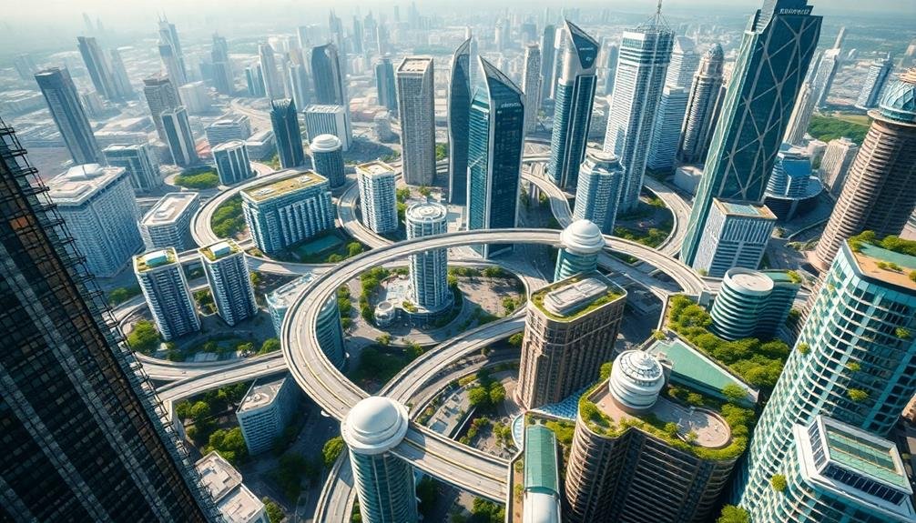
Aerial Mapping for Urban Analysis

Aerial mapping has revolutionized urban analysis, offering a bird's-eye view of cities that was once impossible to achieve. You'll find that this technology provides invaluable insights into urban patterns, land use, and infrastructure. With high-resolution imagery and 3D modeling, you can now visualize entire cityscapes in stunning detail.
You're able to identify urban sprawl, assess green spaces, and analyze traffic patterns with unprecedented accuracy. This bird's-eye perspective allows you to spot potential development areas and evaluate the impact of proposed projects on the surrounding environment.
You'll also find it easier to track changes over time, comparing historical imagery to current views. Aerial mapping isn't just about pretty pictures. It's a powerful tool for urban planners, architects, and policymakers.
You can use it to make data-driven decisions about zoning, transportation, and public services. It helps you understand how people move through the city and interact with their environment.
You'll even be able to assess the urban heat island effect and plan for climate resilience. With aerial mapping, you're not just seeing the city; you're understanding its complex systems and planning for its future.
Drone-Captured Cityscapes
The rise of drone technology has taken urban imagery to new heights, quite literally. You'll find that drones offer unique perspectives of cityscapes, capturing angles and views previously inaccessible to urban planners and designers. These aerial snapshots provide a thorough understanding of urban layouts, helping you identify patterns, bottlenecks, and potential areas for improvement.
With drone-captured imagery, you can analyze building heights, green spaces, and traffic flow more efficiently. You'll notice how sunlight interacts with structures throughout the day, pinpointing areas that may benefit from redesign to improve natural lighting. Drones also allow you to monitor construction progress and assess the impact of new developments on existing infrastructure.
You'll appreciate how drone footage reveals the intricate network of streets, alleyways, and public spaces that make up a city's fabric. This bird's-eye view helps you identify underutilized areas and potential locations for urban renewal projects.
3D Modeling of Urban Environments

Countless urban planners and architects now rely on 3D modeling to revolutionize their approach to city design. You'll find these digital representations providing an immersive, interactive view of urban landscapes that traditional 2D maps can't match.
With 3D models, you can visualize proposed developments, analyze sight lines, and assess the impact of new structures on existing neighborhoods.
You'll appreciate how these models allow for quick iterations and adjustments. They're invaluable for testing different scenarios, from traffic flow to shadow studies. You can explore how a new skyscraper might affect wind patterns or how a park could influence local microclimates.
These models also integrate data on population density, energy consumption, and infrastructure capacity.
When you're presenting plans to stakeholders, 3D models offer a powerful communication tool. They help you convey complex ideas more effectively, allowing non-experts to grasp the full scope of urban projects.
You'll find that this technology enhances collaboration between various disciplines involved in urban planning. It's not just about aesthetics; it's about creating smarter, more sustainable cities that respond to the needs of their inhabitants.
Traffic Flow and Infrastructure Assessment

Building on the power of 3D modeling, urban planners now employ sophisticated tools to analyze traffic flow and assess infrastructure needs. You'll find that these advanced technologies allow for real-time simulations of traffic patterns, helping identify bottlenecks and congestion points before they become problematic.
With these tools, you can predict how changes in road layouts, traffic light timing, or the addition of bike lanes might impact overall city movement. They'll also help you assess the capacity of existing infrastructure, from roads and bridges to public transportation systems, allowing for proactive maintenance and upgrades.
You'll appreciate how these assessments factor in future growth projections, ensuring that infrastructure planning isn't just reactive but anticipatory. By integrating data on population trends, economic development, and environmental factors, you can make informed decisions about where to invest in new infrastructure or how to optimize existing systems.
Moreover, you'll find these tools invaluable for testing various urban design scenarios, helping you create more efficient, sustainable, and livable cities. They'll enable you to balance the needs of different transportation modes, from pedestrians to autonomous vehicles, ensuring a harmonious urban flow.
Green Space Integration From Above

Birds-eye views of cities reveal a tapestry of concrete and green, but you'll find that modern urban planners are increasingly focused on maximizing those verdant patches.
From above, you'll notice how green spaces are strategically integrated into urban landscapes, creating a network of parks, rooftop gardens, and tree-lined streets.
These aerial perspectives allow you to see the bigger picture of how green infrastructure can combat urban heat islands, improve air quality, and enhance biodiversity.
You'll observe that successful green space integration from above often includes:
- Interconnected park systems that form green corridors
- Rooftop gardens on commercial and residential buildings
- Urban forests strategically planted to maximize canopy cover
- Wetlands and bioswales for natural water management
- Green belts surrounding city perimeters to limit urban sprawl
Frequently Asked Questions
How Does Sky-High Urban Planning Impact Property Values in Surrounding Areas?
When sky-high urban planning is implemented, you'll likely see property values in surrounding areas increase. You can expect improved views, enhanced infrastructure, and increased demand for nearby real estate, driving up prices in the neighborhood.
What Are the Privacy Concerns Associated With Aerial Urban Design Techniques?
You'll face increased privacy risks with aerial urban design. Drones and satellites can capture detailed images of your property. Your daily activities might be observed from above, and your personal data could be collected without your knowledge.
How Do Planners Incorporate Historical Preservation Into Sky-High Urban Development Projects?
You'll find planners integrating historical preservation into sky-high projects by carefully blending old and new. They'll maintain landmark facades, incorporate heritage elements into modern designs, and create visual corridors that highlight historic structures amid towering skyscrapers.
What Role Does Public Opinion Play in Approving Vertical Urban Expansion Plans?
You'll find public opinion plays a vital role in approving vertical urban expansion. It's often the deciding factor, as community feedback can make or break a project. You'll see developers actively seeking public support through engagement initiatives.
How Does Sky-High Urban Planning Address Issues of Social Equity and Gentrification?
You'll find sky-high urban planning tackles equity and gentrification by integrating affordable housing, creating mixed-income communities, and improving public spaces. It's essential to involve diverse stakeholders and implement policies that protect existing residents from displacement.
In Summary
You've now glimpsed the future of urban planning from a bird's-eye view. By embracing aerial technologies, you're revolutionizing how cities are designed and managed. You're seeing patterns, flows, and opportunities that weren't visible before. As you integrate these sky-high perspectives into your planning process, you'll create more efficient, sustainable, and livable urban spaces. The city of tomorrow is taking shape, and you're viewing it from an entirely new angle.
As educators and advocates for responsible drone use, we’re committed to sharing our knowledge and expertise with aspiring aerial photographers.


Leave a Reply