
Aerial weed detection has transformed precision agriculture, giving you unprecedented control over crop management. Using drones equipped with high-resolution cameras and advanced sensors, you can now map large areas quickly and efficiently. Machine learning algorithms process the collected imagery, identifying weeds with remarkable accuracy. This technology enables targeted herbicide application, reducing costs and environmental impact. You'll save time compared to manual scouting while improving overall farm productivity. Despite challenges like weather constraints and initial costs, the benefits are substantial. As sensor technology and AI continue to advance, aerial weed detection will become an even more powerful tool in your precision agriculture arsenal.
Evolution of Aerial Weed Mapping

Over the past few decades, aerial weed mapping has undergone a remarkable transformation.
You've witnessed the shift from traditional ground-based surveys to sophisticated airborne techniques. In the early days, farmers and agronomists relied on time-consuming field walks to identify and map weed infestations. This method was labor-intensive and often missed smaller patches of weeds.
As technology advanced, you saw the introduction of manned aircraft surveys. Pilots and observers would fly over fields, manually marking weed locations on maps. While this improved coverage, it still lacked precision and was limited by human observation capabilities.
The real game-changer came with the advent of remote sensing technologies. You now have access to multispectral and hyperspectral imaging, which can detect subtle differences in plant reflectance. These tools allow you to identify weed species and assess their density with unprecedented accuracy.
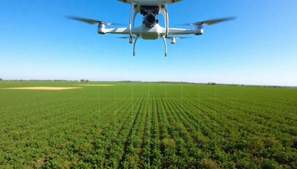
Today, you're seeing the rise of unmanned aerial vehicles (UAVs) or drones in weed mapping. They offer high-resolution imagery, flexibility in data collection, and cost-effectiveness.
Combined with machine learning algorithms, you can now create detailed weed maps faster and more accurately than ever before.
Drone Technology in Precision Agriculture

Drones have revolutionized precision agriculture, offering farmers unprecedented insights into their fields. These unmanned aerial vehicles equipped with high-resolution cameras and advanced sensors can quickly survey large areas, capturing detailed images and data about crop health, soil conditions, and weed infestations.
You'll find that drones are particularly effective for weed detection. They can identify weed patches with remarkable accuracy, allowing you to target herbicide applications precisely. This reduces chemical usage, saves money, and minimizes environmental impact.
Thermal imaging capabilities enable drones to detect moisture stress and irrigation issues, helping you optimize water management.
Drones can also create 3D maps of your fields, providing valuable information about topography and drainage patterns. You'll appreciate the real-time data they deliver, allowing for quick decision-making and timely interventions.
With drone technology, you can monitor crop growth throughout the season, identifying problem areas early and adjusting your management strategies accordingly.
As drone technology continues to advance, you'll see improvements in battery life, payload capacity, and data processing capabilities. This will further enhance their utility in precision agriculture, making them an indispensable tool for modern farmers.
Image Processing for Weed Identification
Once drones capture aerial imagery of your fields, the next step is to process and analyze these images for weed identification. Advanced image processing techniques allow you to transform raw aerial data into actionable insights about weed infestations. These methods typically involve machine learning algorithms trained to recognize various weed species based on their unique spectral signatures and physical characteristics.
To effectively process aerial images for weed identification, you'll need to focus on three key aspects:
- Image pre-processing: This involves enhancing image quality, correcting for distortions, and standardizing color and brightness across images.
- Feature extraction: You'll need to identify and isolate relevant features that distinguish weeds from crops, such as leaf shape, texture, and color patterns.
- Classification algorithms: Implement machine learning models like convolutional neural networks (CNNs) or support vector machines (SVMs) to categorize detected plants as weeds or crops.
Benefits of Aerial Weed Detection

Aerial weed detection's game-changing benefits are revolutionizing modern agriculture. You'll find that this technology offers unprecedented precision in identifying and mapping weed infestations across large areas. By using drones or other aerial platforms equipped with high-resolution cameras and specialized sensors, you can quickly survey entire fields with minimal effort.
One of the most significant advantages is the time and cost savings you'll experience. Instead of manually scouting fields on foot or with ground vehicles, you can cover vast expanses in a fraction of the time. This efficiency allows for more frequent monitoring and earlier detection of weed problems.
You'll also benefit from improved accuracy in weed identification. Aerial imaging can detect subtle differences in plant characteristics that might be missed by the human eye, enabling more targeted and effective weed management strategies. This precision leads to reduced herbicide use, lowering your costs and minimizing environmental impact.
Additionally, you'll gain valuable data for long-term planning. By creating detailed weed maps over time, you can track patterns and trends, informing future crop rotation and management decisions. This data-driven approach enhances your overall farm productivity and sustainability.
Challenges and Future Developments

While aerial weed detection offers numerous advantages, it's not without its challenges. You'll find that weather conditions, such as cloud cover or strong winds, can interfere with data collection. Additionally, the initial cost of implementing aerial detection systems can be high, potentially deterring smaller farms from adopting this technology.
Despite these hurdles, the future of aerial weed detection looks promising. You can expect to see advancements in:
- Sensor technology: Improved sensors will provide higher resolution imagery and more accurate weed identification.
- Machine learning algorithms: Enhanced AI will better distinguish between crops and weeds, even in complex scenarios.
- Integration with other farm systems: Aerial data will seamlessly connect with other precision agriculture tools for thorough farm management.
As the technology evolves, you'll likely see more affordable options entering the market, making aerial weed detection accessible to a broader range of farmers.
You can also anticipate improvements in real-time data processing, allowing for quicker decision-making and more efficient weed management strategies.
With ongoing research and development, aerial weed detection will continue to revolutionize precision agriculture, helping you maximize crop yields while minimizing environmental impact.
Frequently Asked Questions
How Much Does Aerial Weed Detection Equipment Cost for an Average Farm?
You'll find aerial weed detection equipment costs vary widely. For an average farm, you're looking at $5,000 to $20,000 for a basic drone setup. More advanced systems with specialized sensors can run $50,000 or more.
Can Aerial Weed Detection Systems Identify Herbicide-Resistant Weeds?
You'll find that aerial weed detection systems can identify herbicide-resistant weeds. They use advanced imaging and AI to spot unique characteristics of resistant plants. This helps you target your herbicide use and manage resistant populations more effectively.
Are There Regulations Limiting Drone Use for Agricultural Weed Detection?
Yes, there are regulations for drone use in agriculture. You'll need to follow FAA rules, including registering your drone, flying below 400 feet, and keeping it in sight. Some states have additional restrictions you must consider.
How Often Should Aerial Weed Detection Surveys Be Conducted for Optimal Results?
You'll want to conduct aerial weed detection surveys every 2-4 weeks during the growing season. This frequency allows you to catch weed growth early, optimize herbicide applications, and adjust your management strategies as needed for best results.
Can Aerial Weed Detection Technology Be Integrated With Existing Farm Management Software?
Yes, you can integrate aerial weed detection with your farm management software. It'll enhance your precision agriculture efforts, allowing you to seamlessly incorporate weed data into your existing systems for better decision-making and targeted treatments.
In Summary
You've seen how aerial weed detection is revolutionizing precision agriculture. As drone technology and image processing advance, you'll have more powerful tools at your disposal. You'll save time, reduce herbicide use, and boost crop yields. While challenges remain, you can expect continued improvements in accuracy and efficiency. Embrace this technology, and you'll be at the forefront of sustainable farming practices. The future of weed management is taking flight—don't be left behind.
As educators and advocates for responsible drone use, we’re committed to sharing our knowledge and expertise with aspiring aerial photographers.


Leave a Reply