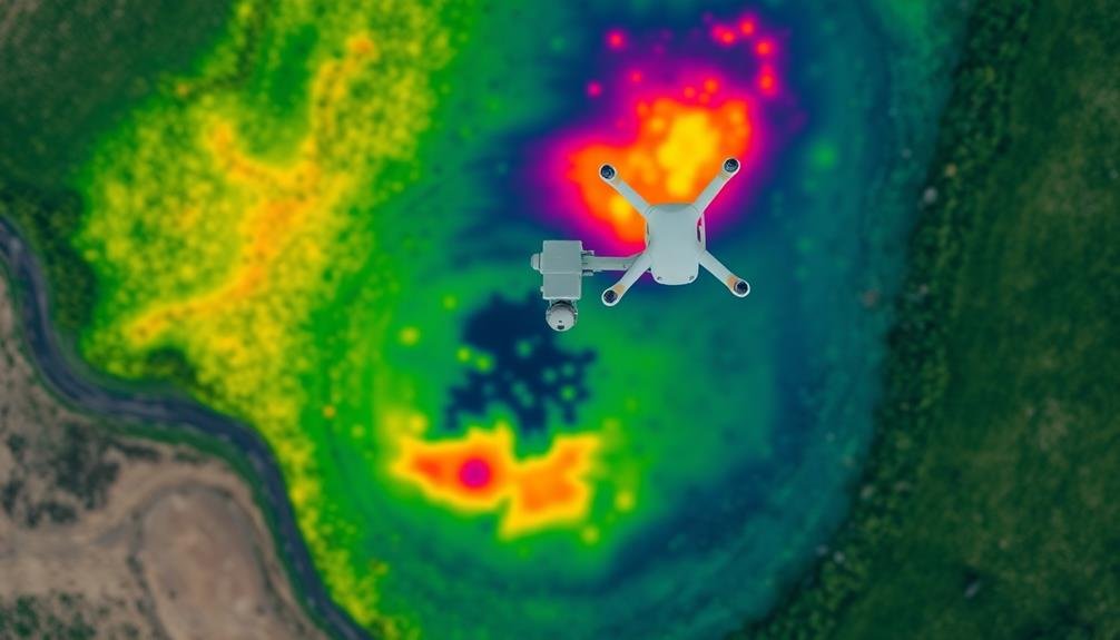
You're witnessing a revolution in landfill management as cutting-edge drone technology takes to the skies to map methane emissions with unprecedented precision. These high-tech surveys use advanced sensors, infrared cameras, and real-time data processing to detect even minute methane concentrations. Drones offer a cost-effective, efficient solution for monitoring large areas, creating detailed 3D maps, and identifying methane hotspots. This technology enhances environmental impact assessments, guarantees regulatory compliance, and paves the way for smarter waste management practices. As you explore this innovative approach, you'll discover how it's transforming the future of landfill operations and environmental protection.
The Methane Challenge

Methane, a potent greenhouse gas, poses a significant challenge in the fight against climate change. It's 28 times more effective at trapping heat than carbon dioxide over a 100-year period, making it a vital target for emissions reduction. Landfills are a major source of methane, accounting for about 15% of global methane emissions.
You're probably wondering why landfills produce so much methane. It's due to the decomposition of organic waste in anaerobic conditions. As trash piles up and gets buried, bacteria break down the organic matter, releasing methane as a byproduct. This process can continue for decades after a landfill closes.
Identifying and quantifying methane emissions from landfills is essential for effective mitigation strategies. However, it's not an easy task. Methane leaks can be sporadic and difficult to detect using traditional ground-based methods.
That's where high-tech surveys come in. By using advanced sensors mounted on aircraft or satellites, you can now map methane emissions across large areas quickly and accurately. This technology is revolutionizing how we track and manage landfill methane emissions.
Drone Technology Advancements

Three key advancements in drone technology have revolutionized landfill methane mapping. First, you'll find enhanced sensor capabilities that allow drones to detect even minute methane concentrations. These sophisticated sensors can differentiate between methane and other gases, providing accurate readings of landfill emissions.
Second, you'll notice improved flight endurance and stability. Modern drones can stay airborne for longer periods, covering larger areas in a single flight. They're also equipped with advanced stabilization systems, ensuring steady data collection even in windy conditions.
Lastly, you'll benefit from real-time data processing and transmission. Drones now come with onboard computers that can analyze data on the fly, sending instant alerts if methane levels exceed predetermined thresholds. This immediate feedback allows for quick response to potential leaks or hotspots.
These advancements have made drone surveys more efficient, cost-effective, and accurate than ever before. You can now map entire landfills in a fraction of the time it used to take, with higher precision and less human error.
As a result, you're better equipped to monitor and manage methane emissions, contributing to more effective environmental protection strategies.
Aerial Mapping Techniques
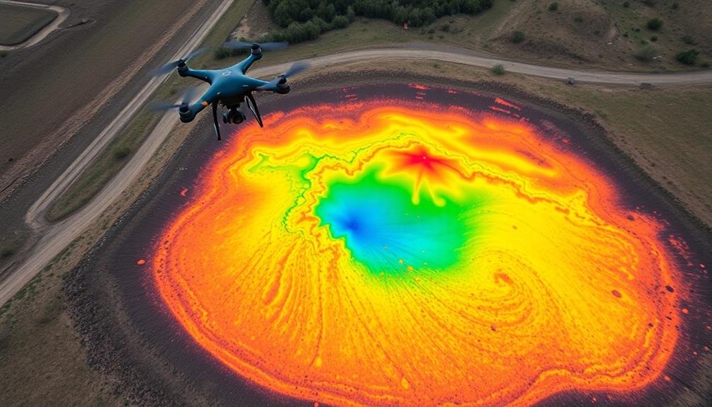
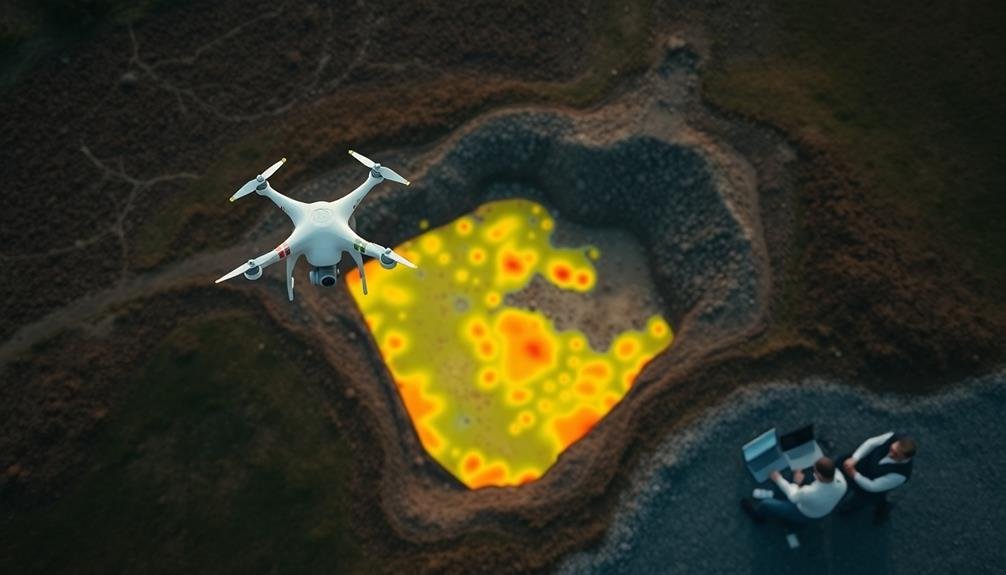
When you're conducting aerial mapping of landfill methane, you'll employ several key techniques to guarantee extensive and accurate data collection. These methods involve using specialized sensors and cameras mounted on drones or aircraft to detect and measure methane emissions. You'll typically fly in a grid pattern over the landfill site, ensuring complete coverage of the area.
One vital technique is infrared thermography, which detects temperature differences that can indicate methane leaks. You'll also use laser-based systems like LiDAR to create detailed 3D maps of the landfill's surface. Multispectral imaging helps you identify vegetation stress patterns that might signal underground gas migration.
To maximize the effectiveness of your aerial mapping, you'll want to:
- Plan flights during ideal weather conditions
- Calibrate sensors before each flight
- Use GPS for precise positioning and data georeferencing
- Conduct multiple passes at different altitudes
- Combine data from various sensors for thorough analysis
Sensor Integration for Precision

To achieve high-precision landfill methane mapping, you'll need to integrate multiple sensors seamlessly. Combining methane detectors, GPS units, and imaging systems creates a powerful suite of tools for accurate data collection.
You'll want to use infrared cameras to detect temperature variations, which can indicate methane hotspots. Pair these with high-sensitivity methane analyzers to measure gas concentrations in parts per million.
Don't forget to incorporate real-time kinematic GPS for pinpoint location accuracy. This guarantees you can map methane emissions with centimeter-level precision.
You'll also need to integrate these sensors with a central data processing unit that can synchronize and correlate readings from all devices.
Consider adding wind sensors to your setup. They'll help you account for atmospheric conditions that affect methane dispersion.
For thorough coverage, you might include both fixed-wing and multi-rotor drones in your fleet. Each type offers unique advantages for different mapping scenarios.
Data Collection and Analysis
After you've integrated your sensors, it's time to immerse yourself in data collection and analysis. You'll need to fly your drone in a predetermined pattern over the landfill, ensuring complete coverage. As you collect data, it's essential to maintain consistent altitude and speed for accurate readings. Your sensors will capture methane concentrations, GPS coordinates, and atmospheric conditions simultaneously.
Once you've completed your flight, you'll process the raw data using specialized software. This software will help you create detailed methane emission maps, identifying hotspots and quantifying overall emissions. You'll need to analyze these maps carefully, looking for patterns and anomalies that might indicate areas of concern.
To make the most of your data collection and analysis efforts:
- Calibrate your sensors before each flight
- Use a standardized flight pattern for consistency
- Store raw data securely and create backups
- Apply appropriate data filtering techniques
- Compare results with historical data when available
Real-Time Emission Detection
Real-time emission detection takes your landfill methane mapping to the next level. By utilizing advanced sensors and data processing techniques, you can identify methane leaks as they occur, enabling swift responses and more effective mitigation strategies.
These systems typically employ a combination of remote sensing technologies, including infrared cameras, laser-based detectors, and spectroscopic analyzers. You'll find that real-time detection offers significant advantages over periodic surveys, as it provides continuous monitoring and alerts you to sudden changes in emission patterns.
To better understand the components of a real-time emission detection system, consider the following table:
| Component | Function | Benefits |
|---|---|---|
| Sensors | Detect methane concentrations | High sensitivity, continuous monitoring |
| Data processing unit | Analyze sensor data | Real-time interpretation, pattern recognition |
| Alert system | Notify operators of anomalies | Rapid response, reduced environmental impact |
Environmental Impact Assessment

Environmental impact assessment plays an essential role in understanding the broader implications of landfill methane emissions. When you're evaluating the effects of these emissions, you'll need to take into account various factors that extend beyond the immediate vicinity of the landfill.
You're looking at how methane contributes to global warming, affects local air quality, and potentially impacts nearby ecosystems.
By conducting thorough assessments, you're able to quantify the environmental costs associated with landfill methane and identify areas for mitigation. This information is vital for policymakers, environmental agencies, and landfill operators to make informed decisions about waste management practices and emission reduction strategies.
To effectively assess the environmental impact of landfill methane, you'll want to focus on:
- Greenhouse gas contribution and climate change implications
- Effects on local air quality and public health
- Potential contamination of groundwater and soil
- Impact on surrounding flora and fauna
- Long-term ecological changes in the area
Regulatory Compliance and Reporting

You'll need to familiarize yourself with emission monitoring requirements set by environmental agencies for landfill methane.
It's essential to adhere to specific data reporting protocols, which often include regular submissions of methane levels and mitigation efforts.
If you don't comply with these regulations, you may face significant penalties, including fines and potential legal action.
Emission Monitoring Requirements
Why do landfill operators need to monitor methane emissions? It's not just about environmental responsibility; it's a legal requirement.
You'll find that regulatory bodies mandate regular monitoring to guarantee compliance with emission standards and protect public health.
Emission monitoring requirements vary depending on your location, but you'll typically need to:
- Conduct surface emission monitoring quarterly
- Perform continuous monitoring of landfill gas collection systems
- Submit annual greenhouse gas reports to environmental agencies
- Maintain detailed records of all monitoring activities
- Implement corrective actions if emissions exceed specified thresholds
You're responsible for using approved monitoring methods and equipment.
These often include portable flame ionization detectors for surface scans and fixed gas analyzers for continuous monitoring. You'll need to calibrate your instruments regularly to guarantee accuracy.
If you're operating a larger landfill, you may be required to use more advanced techniques like optical gas imaging or aerial surveys.
These methods can provide a thorough view of your site's emissions and help you identify problem areas quickly.
Data Reporting Protocols
When it comes to data reporting protocols, landfill operators must adhere to strict guidelines to secure regulatory compliance. You'll need to submit detailed reports to the appropriate regulatory agencies, typically on a quarterly or annual basis. These reports should include extensive data on methane emissions, collection system efficiency, and any exceedances of permitted levels.
You're required to use standardized reporting forms and electronic submission systems specified by your regulatory body. Confirm you're accurately recording all relevant data points, including gas flow rates, methane concentrations, and surface emission readings.
Don't forget to document any equipment malfunctions or maintenance activities that may have affected your measurements. You must maintain thorough records of all raw data, calibration logs, and quality assurance procedures.
Be prepared for potential audits by keeping these records easily accessible for at least five years. It's essential to report any significant deviations from normal operations or unexpected emission spikes promptly.
Penalties for Non-Compliance
The hammer of regulatory agencies falls hard on landfill operators who fail to comply with methane emission regulations. You'll face steep fines, operational restrictions, and potential legal action if you don't adhere to the rules.
These penalties aren't just slaps on the wrist; they're designed to guarantee compliance and protect the environment.
If you're found non-compliant, you could encounter:
- Monetary fines ranging from thousands to millions of dollars
- Mandatory facility upgrades at your own expense
- Temporary or permanent closure of your landfill
- Criminal charges for severe or repeated violations
- Damage to your company's reputation and public image
Don't underestimate the power of regulatory bodies. They've the authority to conduct surprise inspections, issue cease-and-desist orders, and even revoke your operating permits.
It's vital to stay on top of your methane monitoring and reporting obligations.
Cost-Effective Monitoring Solutions

You'll find that drone-based methane detection offers a cost-effective solution for landfill monitoring.
These unmanned aerial vehicles can cover large areas quickly, equipped with sensors to pinpoint methane leaks with high precision.
Additionally, satellite imagery analysis provides a broader perspective, allowing you to track methane emissions over time and identify trends across multiple landfill sites.
Drone-Based Methane Detection
Drone-based methane detection offers a cost-effective solution for landfill operators seeking to monitor emissions. You'll find that these unmanned aerial vehicles equipped with specialized sensors can quickly survey large areas, providing real-time data on methane concentrations. This technology allows you to identify hotspots and leaks with precision, enabling targeted mitigation efforts.
By using drones, you can reduce the need for ground-based surveys, saving time and resources. They're particularly useful for accessing hard-to-reach or dangerous areas of landfills. The data collected can be integrated with mapping software, giving you a thorough view of methane emissions across your site.
Here are key benefits of drone-based methane detection:
- Increased safety for personnel
- Higher frequency of surveys possible
- Improved accuracy in pinpointing emission sources
- Cost savings compared to traditional monitoring methods
- Ability to track emissions over time for trend analysis
As regulations tighten and public awareness grows, investing in drone technology for methane detection can help you stay compliant and demonstrate your commitment to environmental stewardship.
You'll find that this approach not only improves your monitoring capabilities but also enhances your overall landfill management strategy.
Satellite Imagery Analysis
While drones offer localized methane detection, satellite imagery analysis provides a broader perspective for monitoring landfill emissions.
You'll find that satellites equipped with advanced sensors can cover vast areas quickly, making them ideal for large-scale methane mapping. These satellites use spectral imaging to identify methane plumes, allowing you to pinpoint emission hotspots across multiple landfills simultaneously.
You can access historical satellite data to track emission trends over time, helping you identify patterns and assess the effectiveness of mitigation efforts. By combining this information with weather data, you'll gain insights into how atmospheric conditions affect methane dispersion from landfills.
Satellite imagery analysis is particularly cost-effective for ongoing monitoring. You won't need to deploy ground teams or drones regularly, as satellites continuously collect data. This approach also allows you to monitor remote or hard-to-access landfills easily.
However, you should be aware of limitations. Satellite imagery may have lower resolution compared to drone surveys, and cloud cover can interfere with data collection.
To maximize the benefits, you'll often need to integrate satellite analysis with other monitoring methods for thorough landfill methane mapping.
Future of Landfill Management

The future of landfill management is poised for a technological revolution. You'll see a shift towards smart, data-driven systems that optimize waste management and reduce environmental impact. Advanced sensors and AI algorithms will work together to monitor landfill conditions in real-time, allowing for proactive maintenance and methane capture.
You can expect these innovations to transform landfill operations:
- Automated sorting systems using machine learning
- Robotic waste compactors for improved space utilization
- Blockchain-based waste tracking for enhanced accountability
- Biogas-to-energy conversion plants integrated into landfill sites
- Drone-assisted site inspections and emissions monitoring
These technologies will help you manage landfills more efficiently and sustainably. You'll be able to extend the lifespan of existing sites, reduce greenhouse gas emissions, and even turn waste into valuable resources.
As regulations become stricter, you'll find these high-tech solutions essential for compliance and cost-effective operations.
The integration of IoT devices and big data analytics will give you unprecedented insights into waste patterns and landfill performance. You'll make informed decisions about waste diversion, recycling programs, and landfill expansion based on accurate, up-to-date information.
Frequently Asked Questions
How Do Weather Conditions Affect Methane Mapping Accuracy?
Weather conditions greatly impact methane mapping accuracy. You'll find that wind can disperse methane plumes, rain can absorb the gas, and temperature inversions can trap it. Cloud cover may also interfere with some remote sensing techniques.
What Training Is Required for Drone Operators in Landfill Methane Detection?
You'll need training in drone piloting, methane sensor operation, and safety protocols. You should learn data collection techniques, regulatory compliance, and interpreting methane readings. It's crucial to understand landfill operations and gas migration patterns too.
Can This Technology Be Used for Other Types of Gas Emissions?
Yes, you can use this technology for detecting various gas emissions. It's adaptable to different types of gases, including industrial pollutants and greenhouse gases. You'll find it's useful for monitoring air quality and identifying emission sources in diverse settings.
How Often Should Landfill Methane Mapping Surveys Be Conducted?
You should conduct landfill methane mapping surveys at least annually. However, if you've made significant changes or noticed unusual emissions, you'll want to increase the frequency. Quarterly surveys can provide more detailed monitoring and help you address issues promptly.
Are There Any Potential Health Risks for Workers During Drone Mapping Operations?
You'll face minimal health risks during drone mapping operations. However, you should be aware of potential hazards like tripping, falling objects, or exposure to methane. Always follow safety protocols and wear appropriate protective equipment.
In Summary
You've seen how cutting-edge drone technology is revolutionizing landfill methane monitoring. By embracing these aerial mapping techniques, you're not only improving environmental safety but also streamlining regulatory compliance. As you integrate advanced sensors and data analysis, you'll gain unprecedented insights into methane emissions. Moving forward, you'll find these cost-effective solutions essential for responsible landfill management. Stay ahead of the curve and continue exploring innovative ways to tackle the methane challenge.
As educators and advocates for responsible drone use, we’re committed to sharing our knowledge and expertise with aspiring aerial photographers.


Leave a Reply