Three key UAV techniques for tracking volcanic eruptions are thermal imaging surveys, gas sampling missions, and photogrammetry for topographic changes. Thermal cameras detect heat signatures from lava flows and fumaroles, creating detailed temperature maps. Gas sampling UAVs collect and analyze volcanic gases to assess magma composition and eruption potential. Photogrammetry involves capturing images to create 3D models and digital elevation maps, tracking topographic changes over time. These techniques provide safer, more efficient, and highly detailed data collection compared to traditional methods. By employing these advanced UAV technologies, you'll gain an all-encompassing understanding of volcanic activity and its potential impacts.
Thermal Imaging Surveys
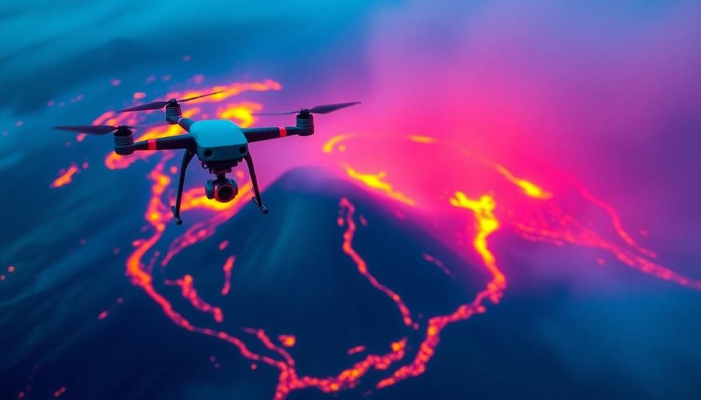
Thermal imaging cameras mounted on UAVs have revolutionized volcanic monitoring. You'll find these devices can detect heat signatures from lava flows, fumaroles, and other volcanic features, providing vital data on eruption patterns and potential hazards.
By flying UAVs equipped with thermal sensors over active volcanoes, you're able to create detailed temperature maps of the area, identifying hotspots and tracking changes over time. You can use these surveys to assess the extent of lava flows, predict their movement, and locate hidden vents or fissures.
The high-resolution imagery you'll obtain allows for precise measurements of surface temperatures, helping you distinguish between different types of volcanic activity. You'll also be able to detect precursory signs of eruptions, such as increased heat flux from the crater or flanks of the volcano.
When conducting thermal imaging surveys, you'll need to take into account factors like flight altitude, camera sensitivity, and atmospheric conditions. You can enhance the effectiveness of your surveys by combining thermal data with visual imagery and other sensor readings, creating a thorough picture of volcanic activity.
Gas Sampling Missions

Gas sampling missions are a vital aspect of UAV-based volcanic monitoring. They allow you to collect and analyze gases emitted from volcanoes, providing important data on magma composition and eruption potential. You'll equip your UAV with specialized sensors and sampling devices to measure concentrations of sulfur dioxide, carbon dioxide, and other volcanic gases.
When planning a gas sampling mission, you'll need to evaluate flight paths that maximize data collection while ensuring the UAV's safety. You'll often fly the drone through visible gas plumes, using real-time telemetry to adjust its course as needed. It's critical to program altitude changes to capture gases at various heights, as concentrations can vary considerably.
You'll find that UAVs offer notable advantages over traditional ground-based or manned aircraft sampling methods. They can access dangerous areas, fly closer to emission sources, and provide higher temporal and spatial resolution data.
However, you'll need to account for challenges like corrosive gases damaging sensors and the need for frequent calibration. By integrating gas sampling missions into your volcanic monitoring strategy, you'll gain valuable insights into eruption dynamics and improve your ability to forecast volcanic activity.
Photogrammetry for Topographic Changes

While gas sampling provides critical chemical data, monitoring physical changes in volcanic landscapes is equally important. That's where photogrammetry comes in. You'll find that UAVs equipped with high-resolution cameras can capture detailed images of volcanic terrain, allowing you to create accurate 3D models and digital elevation maps.
By comparing these models over time, you can track topographic changes caused by volcanic activity. You'll be able to:
- Measure lava flow volumes and rates
- Detect ground deformation and bulging
- Identify new fissures or crater formations
UAV-based photogrammetry offers several advantages over traditional surveying methods. It's faster, safer, and more cost-effective, especially in hazardous volcanic environments. You can cover large areas quickly and repeatedly, ensuring consistent monitoring.
To get the best results, you'll need to plan your flight paths carefully. Overlapping images from multiple angles are essential for accurate 3D reconstruction. You'll also want to use ground control points for precise georeferencing.
Frequently Asked Questions
How Do UAVS Handle Extreme Weather Conditions During Volcanic Eruption Tracking?
You'll find UAVs equipped with thermal sensors, reinforced frames, and advanced stabilization systems. They're designed to withstand high temperatures, ash, and turbulence. Operators often use real-time weather data to plan safe flight paths and altitudes.
What Are the Legal Restrictions for Using UAVS Near Active Volcanoes?
You'll face various legal restrictions when using UAVs near active volcanoes. They often include altitude limits, no-fly zones, and permit requirements. You'll need to check local regulations, as rules can vary between countries and regions.
How Long Can UAVS Operate Continuously During Volcanic Monitoring Missions?
You'll find UAVs can operate for 30 minutes to several hours during volcanic monitoring. It depends on the drone's size, battery life, and payload. Larger, fixed-wing UAVs typically fly longer than smaller quadcopters. Always check local regulations.
What Safety Measures Protect UAVS From Damage Caused by Volcanic Debris?
You'll want to equip your UAVs with protective coatings, reinforced components, and heat-resistant materials. Using collision avoidance systems, real-time monitoring, and pre-programmed flight paths can help keep them safe from volcanic debris. Don't forget backup systems too!
How Do Researchers Transmit Real-Time Data From UAVS During Volcanic Eruptions?
You'll find researchers use satellite communication systems to transmit real-time data from UAVs. They'll often employ specialized radio links, 4G/5G networks, or even Wi-Fi connections when possible. Data's relayed to ground stations for immediate analysis.
In Summary
You've now explored three powerful UAV techniques for monitoring volcanic activity. By utilizing thermal imaging, gas sampling, and photogrammetry, you're better equipped to track eruptions safely and effectively. These methods provide essential data on temperature changes, gas emissions, and topographic shifts. As drone technology advances, you'll find even more innovative ways to study volcanoes. Remember, staying up-to-date with these techniques will help you contribute to important volcanic research and hazard mitigation efforts.
As educators and advocates for responsible drone use, we’re committed to sharing our knowledge and expertise with aspiring aerial photographers.


Leave a Reply